National Register of Historic Places listings in Jackson County, West Virginia
National Register of Historic Places listings in Jackson County, West Virginia
Jump to navigation
Jump to search

Location of Jackson County in West Virginia
This is a list of the National Register of Historic Places listings in Jackson County, West Virginia.
This is intended to be a complete list of the properties and districts on the National Register of Historic Places in Jackson County, West Virginia, United States. The locations of National Register properties and districts for which the latitude and longitude coordinates are included below, may be seen in a Google map.[1]
There are 10 properties and districts listed on the National Register in the county. Another property was once listed but has been removed.
This National Park Service list is complete through NPS recent listings posted November 16, 2018.[2]
Barbour - |
Current listings[edit]
| [3] | Name on the Register | Image | Date listed[4] | Location | City or town | Description |
|---|---|---|---|---|---|---|
1 | Armstrong House |  | February 12, 1980 (#80004023) | 315 North St. 38°49′12″N 81°42′51″W / 38.820000°N 81.714167°W / 38.820000; -81.714167 (Armstrong House) | Ripley | |
2 | Clerc-Carson House |  | October 29, 1992 (#92001482) | 121 North St. 38°49′10″N 81°42′31″W / 38.819444°N 81.708611°W / 38.819444; -81.708611 (Clerc-Carson House) | Ripley | |
3 | Faber Double-Crib Barn | September 7, 2005 (#05001007) | 1106 County Route 21 38°37′14″N 81°39′57″W / 38.620556°N 81.665833°W / 38.620556; -81.665833 (Faber Double-Crib Barn) | Kenna | ||
4 | Lemley-Wood-Sayer House |  | October 30, 1985 (#85003409) | 301 Walnut St. 38°56′55″N 81°45′36″W / 38.948611°N 81.760000°W / 38.948611; -81.760000 (Lemley-Wood-Sayer House) | Ravenswood | |
5 | Otterbein Church | April 1, 1998 (#98000286) | County Route 87/11, near junction with County Route 5 38°49′54″N 81°47′36″W / 38.831667°N 81.793333°W / 38.831667; -81.793333 (Otterbein Church) | Evans | ||
6 | Rankin Octagonal Barn | 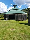 | July 9, 1985 (#85001551) | County Route 3 38°56′45″N 81°41′44″W / 38.945833°N 81.695556°W / 38.945833; -81.695556 (Rankin Octagonal Barn) | Silverton | |
7 | Ravenswood "Old Town" Historic District | 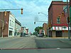 | March 23, 2007 (#07000243) | Bounded by Sandy Creek, the Ohio River, Sycamore St., and adjoining properties and the city limits to the east 38°56′53″N 81°45′39″W / 38.948137°N 81.760965°W / 38.948137; -81.760965 (Ravenswood "Old Town" Historic District) | Ravenswood | |
8 | Ripley Historic District |  | August 25, 2004 (#04000919) | Portions of Charleston and Highlawn Drs., Church, Court, Main, Maple, North, 7th, and South Sts. 38°49′10″N 81°42′36″W / 38.819444°N 81.71°W / 38.819444; -81.71 (Ripley Historic District) | Ripley | |
9 | Sarvis Fork Covered Bridge |  | June 4, 1981 (#81000602) | County Route 21/15 38°55′17″N 81°38′41″W / 38.921389°N 81.644722°W / 38.921389; -81.644722 (Sarvis Fork Covered Bridge) | Sandyville | |
10 | Staats Mill Covered Bridge |  | May 29, 1979 (#79002582) | Off County Route 25 at Cedar Lakes 38°47′40″N 81°41′14″W / 38.794444°N 81.687222°W / 38.794444; -81.687222 (Staats Mill Covered Bridge) | Ripley |
Former listing[edit]
| [3] | Name on the Register | Image | Date listed | Date removed | Location | City or town | Summary |
|---|---|---|---|---|---|---|---|
1 | Old Ravenswood School | August 29, 1979 (#79002581) | April 16, 1984 | Henry St. 38°56′54″N 81°45′24″W / 38.9483°N 81.7568°W / 38.9483; -81.7568 (Old Ravenswood School) | Ravenswood | [5] |
See also[edit]
| Wikimedia Commons has media related to National Register of Historic Places in Jackson County, West Virginia. |
- List of National Historic Landmarks in West Virginia
- National Register of Historic Places listings in West Virginia
References[edit]
^ The latitude and longitude information provided in this table was derived originally from the National Register Information System, which has been found to be fairly accurate for about 99% of listings. For about 1% of NRIS original coordinates, experience has shown that one or both coordinates are typos or otherwise extremely far off; some corrections may have been made. A more subtle problem causes many locations to be off by up to 150 yards, depending on location in the country: most NRIS coordinates were derived from tracing out latitude and longitudes from USGS topographical quadrant maps created under the North American Datum of 1927, which differs from the current, highly accurate WGS84 GPS system used by most on-line maps. Chicago is about right, but NRIS longitudes in Washington are higher by about 4.5 seconds, and are lower by about 2.0 seconds in Maine. Latitudes differ by about 1.0 second in Florida. Some locations in this table may have been corrected to current GPS standards.
^ "National Register of Historic Places: Weekly List Actions". National Park Service, United States Department of the Interior. Retrieved on November 16, 2018.
^ ab Numbers represent an ordering by significant words. Various colorings, defined here, differentiate National Historic Landmarks and historic districts from other NRHP buildings, structures, sites or objects.
^ The eight-digit number below each date is the number assigned to each location in the National Register Information System database, which can be viewed by clicking the number.
^ West Virginia Division of Culture and History: Jackson County NRHP listings
U.S. National Register of Historic Places in West Virginia | ||
|---|---|---|
| Topics |
|  |
| Lists by county |
| |
| Other lists |
| |
| ||
Municipalities and communities of Jackson County, West Virginia, United States | ||
|---|---|---|
County seat: Ripley | ||
| Cities |
|  |
| Unincorporated communities |
| |
| Ghost towns |
| |
| Footnotes | ‡This populated place also has portions in an adjacent county or counties | |
Categories:
- National Register of Historic Places in Jackson County, West Virginia
- Lists of National Register of Historic Places in West Virginia by county
(window.RLQ=window.RLQ||).push(function(){mw.config.set({"wgPageParseReport":{"limitreport":{"cputime":"0.336","walltime":"0.474","ppvisitednodes":{"value":5258,"limit":1000000},"ppgeneratednodes":{"value":0,"limit":1500000},"postexpandincludesize":{"value":129274,"limit":2097152},"templateargumentsize":{"value":10322,"limit":2097152},"expansiondepth":{"value":10,"limit":40},"expensivefunctioncount":{"value":0,"limit":500},"unstrip-depth":{"value":0,"limit":20},"unstrip-size":{"value":3557,"limit":5000000},"entityaccesscount":{"value":1,"limit":400},"timingprofile":["100.00% 324.437 1 -total"," 44.13% 143.180 11 Template:NRHP_row"," 22.62% 73.395 1 Template:Commons_category"," 11.48% 37.238 12 Template:Dts"," 11.05% 35.836 12 Template:Designation/color"," 10.92% 35.419 23 Template:NRHP_color"," 9.42% 30.548 2 Template:Navbox"," 8.72% 28.275 1 Template:National_Register_of_Historic_Places_in_West_Virginia"," 8.61% 27.936 11 Template:Coord"," 7.80% 25.322 23 Template:First_word"]},"scribunto":{"limitreport-timeusage":{"value":"0.083","limit":"10.000"},"limitreport-memusage":{"value":2059705,"limit":52428800}},"cachereport":{"origin":"mw1246","timestamp":"20181122004813","ttl":1900800,"transientcontent":false}}});mw.config.set({"wgBackendResponseTime":96,"wgHostname":"mw1262"});});


