National Register of Historic Places listings in Pendleton County, West Virginia
National Register of Historic Places listings in Pendleton County, West Virginia
Jump to navigation
Jump to search

Location of Pendleton County in West Virginia
This is a list of the National Register of Historic Places listings in Pendleton County, West Virginia.
This is intended to be a complete list of the properties and districts on the National Register of Historic Places in Pendleton County, West Virginia, United States. The locations of National Register properties and districts for which the latitude and longitude coordinates are included below, may be seen in a Google map.[1]
There are 13 properties and districts listed on the National Register in the county.
This National Park Service list is complete through NPS recent listings posted November 16, 2018.[2]
Barbour - |
Current listings[edit]
| [3] | Name on the Register[4] | Image | Date listed[5] | Location | City or town | Description |
|---|---|---|---|---|---|---|
1 | Boggs Mill | August 25, 2004 (#04000915) | U.S. Route 33 and WV 28, north of junction with County Route 9 38°49′09″N 79°23′09″W / 38.819167°N 79.385833°W / 38.819167; -79.385833 (Boggs Mill) | Seneca Rocks | ||
2 | Bowers House | July 10, 1985 (#85001593) | Brandywine-Sugar Grove Rd. 38°30′43″N 79°18′37″W / 38.511944°N 79.310278°W / 38.511944; -79.310278 (Bowers House) | Sugar Grove | ||
3 | Circleville School |  | November 9, 1995 (#95001323) | WV 28 38°40′21″N 79°29′31″W / 38.672500°N 79.491944°W / 38.672500; -79.491944 (Circleville School) | Circleville | |
4 | Cunningham-Hevener House | July 10, 1985 (#85001595) | U.S. Route 220 38°46′40″N 79°17′05″W / 38.777778°N 79.284722°W / 38.777778; -79.284722 (Cunningham-Hevener House) | Upper Tract | ||
5 | Franklin Historic District |  | January 15, 1986 (#86000773) | Roughly bounded by U.S. Route 33, Main St., the Potomac River, and High St. 38°38′37″N 79°19′57″W / 38.643611°N 79.3325°W / 38.643611; -79.3325 (Franklin Historic District) | Franklin | |
6 | McCoy House |  | December 10, 1982 (#82004328) | Main St. 38°38′29″N 79°19′52″W / 38.641389°N 79.331111°W / 38.641389; -79.331111 (McCoy House) | Franklin | |
7 | McCoy Mill |  | January 14, 1986 (#86000780) | Johnstown Rd. 38°36′34″N 79°21′04″W / 38.609444°N 79.351111°W / 38.609444; -79.351111 (McCoy Mill) | Franklin | |
8 | Old Judy Church |  | May 13, 1976 (#76001944) | 10 miles south of Petersburg on U.S. Route 220 38°52′00″N 79°13′07″W / 38.866667°N 79.218611°W / 38.866667; -79.218611 (Old Judy Church) | Petersburg | |
9 | Old Probst Church |  | January 14, 1986 (#86000779) | County Route 21/9 38°35′53″N 79°15′25″W / 38.598056°N 79.256944°W / 38.598056; -79.256944 (Old Probst Church) | Brandywine | |
10 | Pendleton County Poor Farm | 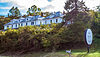 | January 14, 1986 (#86000775) | U.S. Route 220 38°44′59″N 79°17′15″W / 38.749722°N 79.2875°W / 38.749722; -79.2875 (Pendleton County Poor Farm) | Upper Tract | |
11 | Ananias Pitsenbarger Farm |  | August 18, 2011 (#11000557) | WV 23 approximately 1/4 mile south of junction with County Route 23/1 38°34′40″N 79°19′07″W / 38.57783°N 79.318581°W / 38.57783; -79.318581 (Ananias Pitsenbarger Farm) | Franklin | |
12 | Priest Mill |  | April 4, 2000 (#00000250) | Off U.S. Route 220, near the Low-Water Bridge 38°38′22″N 79°19′50″W / 38.639444°N 79.330556°W / 38.639444; -79.330556 (Priest Mill) | Franklin | |
13 | Sites Homestead |  | May 20, 1993 (#93000382) | Seneca Rocks Visitor Center 38°50′09″N 79°22′26″W / 38.835833°N 79.373889°W / 38.835833; -79.373889 (Sites Homestead) | Seneca Rocks |
See also[edit]
| Wikimedia Commons has media related to National Register of Historic Places in Pendleton County, West Virginia. |
- List of National Historic Landmarks in West Virginia
- National Register of Historic Places listings in West Virginia
References[edit]
^ The latitude and longitude information provided in this table was derived originally from the National Register Information System, which has been found to be fairly accurate for about 99% of listings. For about 1% of NRIS original coordinates, experience has shown that one or both coordinates are typos or otherwise extremely far off; some corrections may have been made. A more subtle problem causes many locations to be off by up to 150 yards, depending on location in the country: most NRIS coordinates were derived from tracing out latitude and longitudes from USGS topographical quadrant maps created under the North American Datum of 1927, which differs from the current, highly accurate WGS84 GPS system used by most on-line maps. Chicago is about right, but NRIS longitudes in Washington are higher by about 4.5 seconds, and are lower by about 2.0 seconds in Maine. Latitudes differ by about 1.0 second in Florida. Some locations in this table may have been corrected to current GPS standards.
^ "National Register of Historic Places: Weekly List Actions". National Park Service, United States Department of the Interior. Retrieved on November 16, 2018.
^ Numbers represent an ordering by significant words. Various colorings, defined here, differentiate National Historic Landmarks and historic districts from other NRHP buildings, structures, sites or objects.
^ National Park Service (2008-04-24). "National Register Information System". National Register of Historic Places. National Park Service..mw-parser-output cite.citation{font-style:inherit}.mw-parser-output q{quotes:"""""""'""'"}.mw-parser-output code.cs1-code{color:inherit;background:inherit;border:inherit;padding:inherit}.mw-parser-output .cs1-lock-free a{background:url("//upload.wikimedia.org/wikipedia/commons/thumb/6/65/Lock-green.svg/9px-Lock-green.svg.png")no-repeat;background-position:right .1em center}.mw-parser-output .cs1-lock-limited a,.mw-parser-output .cs1-lock-registration a{background:url("//upload.wikimedia.org/wikipedia/commons/thumb/d/d6/Lock-gray-alt-2.svg/9px-Lock-gray-alt-2.svg.png")no-repeat;background-position:right .1em center}.mw-parser-output .cs1-lock-subscription a{background:url("//upload.wikimedia.org/wikipedia/commons/thumb/a/aa/Lock-red-alt-2.svg/9px-Lock-red-alt-2.svg.png")no-repeat;background-position:right .1em center}.mw-parser-output .cs1-subscription,.mw-parser-output .cs1-registration{color:#555}.mw-parser-output .cs1-subscription span,.mw-parser-output .cs1-registration span{border-bottom:1px dotted;cursor:help}.mw-parser-output .cs1-hidden-error{display:none;font-size:100%}.mw-parser-output .cs1-visible-error{font-size:100%}.mw-parser-output .cs1-subscription,.mw-parser-output .cs1-registration,.mw-parser-output .cs1-format{font-size:95%}.mw-parser-output .cs1-kern-left,.mw-parser-output .cs1-kern-wl-left{padding-left:0.2em}.mw-parser-output .cs1-kern-right,.mw-parser-output .cs1-kern-wl-right{padding-right:0.2em}
^ The eight-digit number below each date is the number assigned to each location in the National Register Information System database, which can be viewed by clicking the number.
U.S. National Register of Historic Places in West Virginia | ||
|---|---|---|
| Topics |
|  |
| Lists by county |
| |
| Other lists |
| |
| ||
Municipalities and communities of Pendleton County, West Virginia, United States | ||
|---|---|---|
County seat: Franklin | ||
| Town |
|  |
| CDP |
| |
| Unincorporated communities |
| |
| Ghost towns |
| |
Categories:
- National Register of Historic Places in Pendleton County, West Virginia
- Lists of National Register of Historic Places in West Virginia by county
(window.RLQ=window.RLQ||).push(function(){mw.config.set({"wgPageParseReport":{"limitreport":{"cputime":"0.408","walltime":"0.559","ppvisitednodes":{"value":6078,"limit":1000000},"ppgeneratednodes":{"value":0,"limit":1500000},"postexpandincludesize":{"value":131055,"limit":2097152},"templateargumentsize":{"value":8702,"limit":2097152},"expansiondepth":{"value":11,"limit":40},"expensivefunctioncount":{"value":0,"limit":500},"unstrip-depth":{"value":1,"limit":20},"unstrip-size":{"value":5515,"limit":5000000},"entityaccesscount":{"value":1,"limit":400},"timingprofile":["100.00% 421.920 1 -total"," 34.23% 144.431 13 Template:NRHP_row"," 28.53% 120.390 1 Template:NRHP_header"," 22.98% 96.951 1 Template:NRISref"," 21.99% 92.771 1 Template:Cite_web"," 17.40% 73.396 1 Template:Commons_category"," 8.80% 37.118 19 Template:NRHP_color"," 8.39% 35.409 14 Template:Designation/color"," 7.49% 31.592 29 Template:First_word"," 7.46% 31.456 13 Template:Coord"]},"scribunto":{"limitreport-timeusage":{"value":"0.148","limit":"10.000"},"limitreport-memusage":{"value":3602188,"limit":52428800}},"cachereport":{"origin":"mw1330","timestamp":"20181122004744","ttl":1900800,"transientcontent":false}}});});{"@context":"https://schema.org","@type":"Article","name":"National Register of Historic Places listings in Pendleton County, West Virginia","url":"https://en.wikipedia.org/wiki/National_Register_of_Historic_Places_listings_in_Pendleton_County,_West_Virginia","sameAs":"http://www.wikidata.org/entity/Q6977159","mainEntity":"http://www.wikidata.org/entity/Q6977159","author":{"@type":"Organization","name":"Contributors to Wikimedia projects"},"publisher":{"@type":"Organization","name":"Wikimedia Foundation, Inc.","logo":{"@type":"ImageObject","url":"https://www.wikimedia.org/static/images/wmf-hor-googpub.png"}},"datePublished":"2009-08-04T15:59:11Z","dateModified":"2018-05-25T03:41:42Z","image":"https://upload.wikimedia.org/wikipedia/commons/c/ce/Map_of_West_Virginia_highlighting_Pendleton_County.svg","headline":"Wikimedia list article"}(window.RLQ=window.RLQ||).push(function(){mw.config.set({"wgBackendResponseTime":85,"wgHostname":"mw1275"});});


