National Register of Historic Places listings in Marshall County, West Virginia
National Register of Historic Places listings in Marshall County, West Virginia
Jump to navigation
Jump to search

Location of Marshall County in West Virginia
This is a list of the National Register of Historic Places listings in Marshall County, West Virginia.
This is intended to be a complete list of the properties and districts on the National Register of Historic Places in Marshall County, West Virginia, United States. The locations of National Register properties and districts for which the latitude and longitude coordinates are included below, may be seen in a Google map.[1]
There are 11 properties and districts listed on the National Register in the county.
This National Park Service list is complete through NPS recent listings posted November 16, 2018.[2]
Barbour - |
Current listings[edit]
| [3] | Name on the Register | Image | Date listed[4] | Location | City or town | Description |
|---|---|---|---|---|---|---|
1 | B & O Railroad Viaduct |  | June 22, 1976 (#76001370) | Spans the Ohio River at the southern end of Benwood 40°00′40″N 80°44′13″W / 40.011°N 80.73685°W / 40.011; -80.73685 (B & O Railroad Viaduct) | Benwood | Extends into Belmont County, Ohio |
2 | Cameron City Pool-PWA Project 1196 |  | July 14, 1993 (#93000612) | Park St. 39°49′46″N 80°34′01″W / 39.829444°N 80.566944°W / 39.829444; -80.566944 (Cameron City Pool-PWA Project 1196) | Cameron | |
3 | Cameron Downtown |  | December 4, 1998 (#98001473) | Roughly bounded by Church St., Waynesburg Ave., Main St., and Park St. 39°49′35″N 80°33′57″W / 39.826389°N 80.565833°W / 39.826389; -80.565833 (Cameron Downtown) | Cameron | |
4 | Bennett Cockayne House |  | December 12, 2002 (#02001521) | 1111 Wheeling Ave. 39°56′33″N 80°45′17″W / 39.942500°N 80.754722°W / 39.942500; -80.754722 (Bennett Cockayne House) | Glen Dale | |
5 | Ferrell-Holt House | 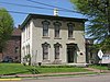 | February 3, 1987 (#86003678) | 609 Jefferson Ave. 39°55′08″N 80°44′52″W / 39.918889°N 80.747778°W / 39.918889; -80.747778 (Ferrell-Holt House) | Moundsville | |
6 | Grave Creek Mound |  | October 15, 1966 (#66000751) | Off WV 2 39°55′01″N 80°44′42″W / 39.916944°N 80.745°W / 39.916944; -80.745 (Grave Creek Mound) | Moundsville | |
7 | McMechen Lockmaster Houses on the Ohio River |  | November 12, 1992 (#92001485) | 623-625 Grant St. 39°59′22″N 80°44′03″W / 39.989444°N 80.734167°W / 39.989444; -80.734167 (McMechen Lockmaster Houses on the Ohio River) | McMechen | |
8 | Moundsville Commercial Historic District |  | March 17, 1995 (#95000252) | Roughly Jefferson Ave. from 2nd to 7th Sts., 7th from Jefferson to Lafayette Ave., and Lafayette south of 7th 39°55′15″N 80°44′49″W / 39.920833°N 80.746944°W / 39.920833; -80.746944 (Moundsville Commercial Historic District) | Moundsville | |
9 | Bushrod Washington Price House |  | November 22, 1995 (#95001326) | 1803 Virginia St. 39°55′22″N 80°43′57″W / 39.922639°N 80.732500°W / 39.922639; -80.732500 (Bushrod Washington Price House) | Moundsville | |
10 | Spencer Cemetery |  | December 12, 2012 (#12001051) | 668 Burley Hill Rd. 39°52′01″N 80°32′15″W / 39.866944°N 80.537500°W / 39.866944; -80.537500 (Spencer Cemetery) | Cameron | |
11 | West Virginia State Penitentiary |  | September 19, 1996 (#96000987) | 818 Jefferson Ave. 39°54′55″N 80°44′34″W / 39.915278°N 80.742778°W / 39.915278; -80.742778 (West Virginia State Penitentiary) | Moundsville |
See also[edit]
| Wikimedia Commons has media related to National Register of Historic Places in Marshall County, West Virginia. |
- List of National Historic Landmarks in West Virginia
- National Register of Historic Places listings in West Virginia
References[edit]
^ The latitude and longitude information provided in this table was derived originally from the National Register Information System, which has been found to be fairly accurate for about 99% of listings. For about 1% of NRIS original coordinates, experience has shown that one or both coordinates are typos or otherwise extremely far off; some corrections may have been made. A more subtle problem causes many locations to be off by up to 150 yards, depending on location in the country: most NRIS coordinates were derived from tracing out latitude and longitudes from USGS topographical quadrant maps created under the North American Datum of 1927, which differs from the current, highly accurate WGS84 GPS system used by most on-line maps. Chicago is about right, but NRIS longitudes in Washington are higher by about 4.5 seconds, and are lower by about 2.0 seconds in Maine. Latitudes differ by about 1.0 second in Florida. Some locations in this table may have been corrected to current GPS standards.
^ "National Register of Historic Places: Weekly List Actions". National Park Service, United States Department of the Interior. Retrieved on November 16, 2018.
^ Numbers represent an ordering by significant words. Various colorings, defined here, differentiate National Historic Landmarks and historic districts from other NRHP buildings, structures, sites or objects.
^ The eight-digit number below each date is the number assigned to each location in the National Register Information System database, which can be viewed by clicking the number.
U.S. National Register of Historic Places in West Virginia | ||
|---|---|---|
| Topics |
|  |
| Lists by county |
| |
| Other lists |
| |
| ||
Municipalities and communities of Marshall County, West Virginia, United States | ||
|---|---|---|
County seat: Moundsville | ||
| Cities |
|  |
| Unincorporated communities |
| |
| Ghost towns |
| |
| Footnotes | ‡This populated place also has portions in an adjacent county or counties | |
Categories:
- National Register of Historic Places in Marshall County, West Virginia
- Lists of National Register of Historic Places in West Virginia by county
(window.RLQ=window.RLQ||).push(function(){mw.config.set({"wgPageParseReport":{"limitreport":{"cputime":"0.352","walltime":"0.492","ppvisitednodes":{"value":5300,"limit":1000000},"ppgeneratednodes":{"value":0,"limit":1500000},"postexpandincludesize":{"value":120900,"limit":2097152},"templateargumentsize":{"value":8986,"limit":2097152},"expansiondepth":{"value":10,"limit":40},"expensivefunctioncount":{"value":0,"limit":500},"unstrip-depth":{"value":0,"limit":20},"unstrip-size":{"value":2913,"limit":5000000},"entityaccesscount":{"value":1,"limit":400},"timingprofile":["100.00% 322.456 1 -total"," 47.21% 152.227 11 Template:NRHP_row"," 21.04% 67.860 1 Template:Commons_category"," 11.66% 37.612 11 Template:Coord"," 10.85% 34.988 11 Template:Dts"," 10.34% 33.352 2 Template:Navbox"," 9.55% 30.781 1 Template:National_Register_of_Historic_Places_in_West_Virginia"," 9.33% 30.073 12 Template:Designation/color"," 8.15% 26.275 14 Template:NRHP_color"," 8.09% 26.101 22 Template:First_word"]},"scribunto":{"limitreport-timeusage":{"value":"0.092","limit":"10.000"},"limitreport-memusage":{"value":2192252,"limit":52428800}},"cachereport":{"origin":"mw1266","timestamp":"20181122004803","ttl":1900800,"transientcontent":false}}});mw.config.set({"wgBackendResponseTime":593,"wgHostname":"mw1266"});});


