National Register of Historic Places listings in Fayette County, West Virginia
National Register of Historic Places listings in Fayette County, West Virginia
Jump to navigation
Jump to search
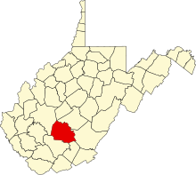
Location of Fayette County in West Virginia
This is a list of the National Register of Historic Places listings in Fayette County, West Virginia.
This is intended to be a complete list of the properties and districts on the National Register of Historic Places in Fayette County, West Virginia, United States. The locations of National Register properties and districts for which the latitude and longitude coordinates are included below, may be seen in an online map.[1]
There are 25 properties and districts listed on the National Register in the county.
This National Park Service list is complete through NPS recent listings posted November 16, 2018.[2]
Barbour - |
Current listings[edit]
| [3] | Name on the Register | Image | Date listed[4] | Location | City or town | Description |
|---|---|---|---|---|---|---|
1 | Altamont Hotel |  | August 29, 1979 (#79002574) | 110 Fayette Ave. 38°03′09″N 81°06′07″W / 38.052500°N 81.101944°W / 38.052500; -81.101944 (Altamont Hotel) | Fayetteville | |
2 | Bank of Glen Jean |  | February 10, 1983 (#83003236) | Main St. 37°55′42″N 81°09′19″W / 37.928333°N 81.155278°W / 37.928333; -81.155278 (Bank of Glen Jean) | Glen Jean | |
3 | Camp Washington-Carver Complex |  | June 20, 1980 (#80004017) | County Route 11/3 38°00′36″N 80°58′14″W / 38.01°N 80.970556°W / 38.01; -80.970556 (Camp Washington-Carver Complex) | Clifftop | |
4 | Contentment |  | December 30, 1974 (#74001996) | Along U.S. Route 60 38°08′06″N 81°06′11″W / 38.135°N 81.103056°W / 38.135; -81.103056 (Contentment) | Ansted | |
5 | Fayette County Courthouse |  | September 6, 1978 (#78002793) | Court St. between Wiseman and Maple Aves. 38°03′13″N 81°06′13″W / 38.053611°N 81.103611°W / 38.053611; -81.103611 (Fayette County Courthouse) | Fayetteville | |
6 | Fayetteville Historic District |  | December 20, 1990 (#90001845) | Roughly bounded by WV 16 and Maple and Fayette Aves. 38°03′05″N 81°06′25″W / 38.051389°N 81.106944°W / 38.051389; -81.106944 (Fayetteville Historic District) | Fayetteville | |
7 | Gauley Bridge Railroad Station |  | May 15, 1980 (#80004018) | Off WV 16/WV 39 38°09′53″N 81°11′46″W / 38.164722°N 81.196111°W / 38.164722; -81.196111 (Gauley Bridge Railroad Station) | Gauley Bridge | |
8 | Glen Ferris Inn | April 25, 1991 (#91000449) | U.S. Route 60 overlooking Kanawha Falls 38°09′01″N 81°12′53″W / 38.150278°N 81.214722°W / 38.150278; -81.214722 (Glen Ferris Inn) | Glen Ferris | ||
9 | Halfway House | December 18, 1978 (#78002792) | Off old U.S. Route 60 38°08′04″N 81°05′43″W / 38.134444°N 81.095278°W / 38.134444; -81.095278 (Halfway House) | Ansted | ||
10 | E. B. Hawkins House | 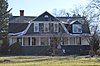 | January 18, 1990 (#89002319) | 120 Fayette Ave. 38°03′12″N 81°06′02″W / 38.053472°N 81.100556°W / 38.053472; -81.100556 (E. B. Hawkins House) | Fayetteville | |
11 | Dr. John Hughart House | March 26, 2001 (#01000262) | Off WV 41 37°58′15″N 80°56′07″W / 37.970825°N 80.935331°W / 37.970825; -80.935331 (Dr. John Hughart House) | Landisburg | ||
12 | Kay Moor |  | November 8, 1990 (#90001641) | Along the New River south of U.S. Route 19 38°02′52″N 81°03′53″W / 38.047778°N 81.064722°W / 38.047778; -81.064722 (Kay Moor) | Fayetteville | |
13 | Main Building |  | June 25, 1980 (#80004019) | West Virginia University Institute of Technology campus 38°10′45″N 81°19′31″W / 38.179167°N 81.325278°W / 38.179167; -81.325278 (Main Building) | Montgomery | |
14 | Mount Hope Historic District | 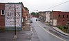 | August 3, 2007 (#07000785) | Portions of Main, Tennessee, Montana, and Virginia Sts., Fayette and Mountain Aves., Stadium Dr., N. Pax Ave., and N. Maryland 37°53′33″N 81°10′04″W / 37.8925°N 81.167778°W / 37.8925; -81.167778 (Mount Hope Historic District) | Mount Hope | |
15 | New Deal Resources in Hawk's Nest State Park Historic District |  | February 4, 2011 (#10001225) | 49 Hawks Nest State Park Rd. 38°07′23″N 81°07′13″W / 38.123056°N 81.120278°W / 38.123056; -81.120278 (New Deal Resources in Hawk's Nest State Park Historic District) | Ansted | |
16 | New River Company General Office Building |  | April 21, 2004 (#04000357) | 411 Main St. 37°53′47″N 81°09′56″W / 37.896389°N 81.165556°W / 37.896389; -81.165556 (New River Company General Office Building) | Mt. Hope | |
17 | New River Gorge Bridge | August 14, 2013 (#13000603) | US 19 over New River 38°04′06″N 81°05′00″W / 38.068333°N 81.083333°W / 38.068333; -81.083333 (New River Gorge Bridge) | Fayetteville | ||
18 | Nuttallburg Coal Mining Complex and Town Historic District |  | August 22, 2007 (#07000846) | County Route 85/2 38°03′00″N 81°02′25″W / 38.0501114°N 81.0403776°W / 38.0501114; -81.0403776 (Nuttallburg Coal Mining Complex and Town Historic District) | Nuttallburg | |
19 | Oak Hill Railroad Depot |  | March 17, 1995 (#95000255) | Junction of Virginia Ave. and Central Ave. 37°58′38″N 81°08′58″W / 37.977222°N 81.149444°W / 37.977222; -81.149444 (Oak Hill Railroad Depot) | Oak Hill | |
20 | Page-Vawter House |  | August 21, 1985 (#85001813) | Route Box 20 38°08′13″N 81°06′06″W / 38.136944°N 81.101667°W / 38.136944; -81.101667 (Page-Vawter House) | Ansted | |
21 | Prince Brothers General Store-Berry Store |  | April 17, 1986 (#86000810) | WV 41 37°51′22″N 81°03′49″W / 37.856111°N 81.063611°W / 37.856111; -81.063611 (Prince Brothers General Store-Berry Store) | Prince | |
22 | Soldiers and Sailors Memorial Building | May 31, 2016 (#16000312) | 200 W. Maple Ave. 38°03′07″N 81°06′19″W / 38.051944°N 81.105278°W / 38.051944; -81.105278 (Soldiers and Sailors Memorial Building) | Fayetteville | ||
23 | Thurmond Historic District | 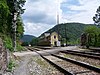 | January 27, 1984 (#84003520) | County Route 25/2 at New River 37°57′29″N 81°04′40″W / 37.958056°N 81.077778°W / 37.958056; -81.077778 (Thurmond Historic District) | Thurmond | |
24 | Tyree Stone Tavern | June 20, 1975 (#75001884) | East of Clifftop off U.S. Route 19 on County Route 10 38°00′42″N 80°54′18″W / 38.011667°N 80.905°W / 38.011667; -80.905 (Tyree Stone Tavern) | Clifftop | ||
25 | Whipple Company Store | 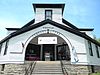 | April 26, 1991 (#91000448) | Junction of WV 612 and County Route 21/20 37°57′31″N 81°09′57″W / 37.958611°N 81.165833°W / 37.958611; -81.165833 (Whipple Company Store) | Scarbro |
See also[edit]
| Wikimedia Commons has media related to National Register of Historic Places in Fayette County, West Virginia. |
- List of National Historic Landmarks in West Virginia
- National Register of Historic Places listings in West Virginia
References[edit]
^ The latitude and longitude information provided in this table was derived originally from the National Register Information System, which has been found to be fairly accurate for about 99% of listings. For about 1% of NRIS original coordinates, experience has shown that one or both coordinates are typos or otherwise extremely far off; some corrections may have been made. A more subtle problem causes many locations to be off by up to 150 yards, depending on location in the country: most NRIS coordinates were derived from tracing out latitude and longitudes from USGS topographical quadrant maps created under the North American Datum of 1927, which differs from the current, highly accurate WGS84 GPS system used by most on-line maps. Chicago is about right, but NRIS longitudes in Washington are higher by about 4.5 seconds, and are lower by about 2.0 seconds in Maine. Latitudes differ by about 1.0 second in Florida. Some locations in this table may have been corrected to current GPS standards.
^ "National Register of Historic Places: Weekly List Actions". National Park Service, United States Department of the Interior. Retrieved on November 16, 2018.
^ Numbers represent an ordering by significant words. Various colorings, defined here, differentiate National Historic Landmarks and historic districts from other NRHP buildings, structures, sites or objects.
^ The eight-digit number below each date is the number assigned to each location in the National Register Information System database, which can be viewed by clicking the number.
U.S. National Register of Historic Places in West Virginia | ||
|---|---|---|
| Topics |
|  |
| Lists by county |
| |
| Other lists |
| |
| ||
Municipalities and communities of Fayette County, West Virginia, United States | ||
|---|---|---|
County seat: Fayetteville | ||
| Cities |
|  |
| Towns |
| |
| CDPs |
| |
| Other unincorporated communities |
| |
| Ghost towns |
| |
| Footnotes | ‡This populated place also has portions in an adjacent county or counties | |
Categories:
- National Register of Historic Places in Fayette County, West Virginia
- Lists of National Register of Historic Places in West Virginia by county
(window.RLQ=window.RLQ||).push(function(){mw.config.set({"wgPageParseReport":{"limitreport":{"cputime":"0.560","walltime":"0.717","ppvisitednodes":{"value":10603,"limit":1000000},"ppgeneratednodes":{"value":0,"limit":1500000},"postexpandincludesize":{"value":222435,"limit":2097152},"templateargumentsize":{"value":21294,"limit":2097152},"expansiondepth":{"value":10,"limit":40},"expensivefunctioncount":{"value":0,"limit":500},"unstrip-depth":{"value":0,"limit":20},"unstrip-size":{"value":3025,"limit":5000000},"entityaccesscount":{"value":1,"limit":400},"timingprofile":["100.00% 459.847 1 -total"," 62.18% 285.915 25 Template:NRHP_row"," 15.05% 69.189 1 Template:Commons_category"," 13.85% 63.712 55 Template:First_word"," 13.78% 63.351 25 Template:Dts"," 12.83% 58.994 25 Template:Coord"," 12.32% 56.671 26 Template:Designation/color"," 10.44% 47.993 24 Template:NRHP_color"," 8.56% 39.361 25 Template:NRHP_Focus"," 6.92% 31.807 2 Template:Navbox"]},"scribunto":{"limitreport-timeusage":{"value":"0.159","limit":"10.000"},"limitreport-memusage":{"value":2439683,"limit":52428800}},"cachereport":{"origin":"mw1265","timestamp":"20181122004825","ttl":1900800,"transientcontent":false}}});});{"@context":"https://schema.org","@type":"Article","name":"National Register of Historic Places listings in Fayette County, West Virginia","url":"https://en.wikipedia.org/wiki/National_Register_of_Historic_Places_listings_in_Fayette_County,_West_Virginia","sameAs":"http://www.wikidata.org/entity/Q12062717","mainEntity":"http://www.wikidata.org/entity/Q12062717","author":{"@type":"Organization","name":"Contributors to Wikimedia projects"},"publisher":{"@type":"Organization","name":"Wikimedia Foundation, Inc.","logo":{"@type":"ImageObject","url":"https://www.wikimedia.org/static/images/wmf-hor-googpub.png"}},"datePublished":"2009-01-08T19:32:15Z","dateModified":"2018-10-14T16:17:51Z","image":"https://upload.wikimedia.org/wikipedia/commons/7/72/Map_of_West_Virginia_highlighting_Fayette_County.svg","headline":"Wikimedia list article"}(window.RLQ=window.RLQ||).push(function(){mw.config.set({"wgBackendResponseTime":852,"wgHostname":"mw1265"});});


