National Register of Historic Places listings in Raleigh County, West Virginia
National Register of Historic Places listings in Raleigh County, West Virginia
Jump to navigation
Jump to search

Location of Raleigh County in West Virginia
This is a list of the National Register of Historic Places listings in Raleigh County, West Virginia.
This is intended to be a complete list of the properties and districts on the National Register of Historic Places in Raleigh County, West Virginia, United States. The locations of National Register properties and districts for which the latitude and longitude coordinates are included below, may be seen in an online map.[1]
There are 9 properties and districts listed on the National Register in the county.
This National Park Service list is complete through NPS recent listings posted November 16, 2018.[2]
Barbour - |
Current listings[edit]
| [3] | Name on the Register | Image | Date listed[4] | Location | City or town | Description |
|---|---|---|---|---|---|---|
1 | Beckley Courthouse Square Historic District |  | August 31, 1994 (#94000722) | Roughly bounded by Prince, Kanawha, Church, Lebanon, Howe, McCreery and Earwood Sts. and Alaska and First Aves. 37°46′36″N 81°11′16″W / 37.776667°N 81.187778°W / 37.776667; -81.187778 (Beckley Courthouse Square Historic District) | Beckley | |
2 | Beckley Feed and Hardware Company |  | August 24, 2001 (#00001309) | 405 Prince St. 37°46′36″N 81°11′38″W / 37.776667°N 81.193889°W / 37.776667; -81.193889 (Beckley Feed and Hardware Company) | Beckley | Demolished in 2013.[5] |
3 | Beckley Mill Site | May 1, 2017 (#100000947) | Worley Rd. at Piney Cr. 37°46′24″N 81°09′03″W / 37.773457°N 81.150818°W / 37.773457; -81.150818 (Beckley Mill Site) | Beckley | ||
4 | Little Beaver Dam | 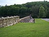 | April 1, 1998 (#98000287) | Little Beaver State Park off WV 307 37°45′18″N 81°04′48″W / 37.755°N 81.08°W / 37.755; -81.08 (Little Beaver Dam) | Crow | |
5 | Phillips-Sprague Mine |  | March 25, 1988 (#88000266) | New River Park[6] 37°47′03″N 81°11′37″W / 37.784167°N 81.193611°W / 37.784167; -81.193611 (Phillips-Sprague Mine) | Beckley | |
6 | St. Colman's Roman Catholic Church and Cemetery |  | August 23, 1984 (#84003658) | County Route 26 37°45′57″N 80°55′16″W / 37.7659513°N 80.9212017°W / 37.7659513; -80.9212017 (St. Colman's Roman Catholic Church and Cemetery) | Dillon | |
7 | Sophia Historic District |  | March 22, 2006 (#06000163) | Main St., between Polk St. and Riffe St. 37°42′34″N 81°15′07″W / 37.709444°N 81.251944°W / 37.709444; -81.251944 (Sophia Historic District) | Sophia | |
8 | Trump-Lilly Farmstead |  | November 8, 1990 (#90001640) | County Route 26/3, 2.5 miles from County Route 26 37°41′54″N 80°54′01″W / 37.698333°N 80.900278°W / 37.698333; -80.900278 (Trump-Lilly Farmstead) | Hinton | Extends into Summers County |
9 | Wildwood | 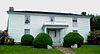 | August 25, 1970 (#70000665) | 117 Laurel Ter. 37°46′18″N 81°10′26″W / 37.771667°N 81.173889°W / 37.771667; -81.173889 (Wildwood) | Beckley |
See also[edit]
| Wikimedia Commons has media related to National Register of Historic Places in Raleigh County, West Virginia. |
- List of National Historic Landmarks in West Virginia
- National Register of Historic Places listings in West Virginia
References[edit]
^ The latitude and longitude information provided in this table was derived originally from the National Register Information System, which has been found to be fairly accurate for about 99% of listings. For about 1% of NRIS original coordinates, experience has shown that one or both coordinates are typos or otherwise extremely far off; some corrections may have been made. A more subtle problem causes many locations to be off by up to 150 yards, depending on location in the country: most NRIS coordinates were derived from tracing out latitude and longitudes from USGS topographical quadrant maps created under the North American Datum of 1927, which differs from the current, highly accurate WGS84 GPS system used by most on-line maps. Chicago is about right, but NRIS longitudes in Washington are higher by about 4.5 seconds, and are lower by about 2.0 seconds in Maine. Latitudes differ by about 1.0 second in Florida. Some locations in this table may have been corrected to current GPS standards.
^ "National Register of Historic Places: Weekly List Actions". National Park Service, United States Department of the Interior. Retrieved on November 16, 2018.
^ Numbers represent an ordering by significant words. Various colorings, defined here, differentiate National Historic Landmarks and historic districts from other NRHP buildings, structures, sites or objects.
^ The eight-digit number below each date is the number assigned to each location in the National Register Information System database, which can be viewed by clicking the number.
^ http://www.register-herald.com/todaysfrontpage/x1566987885/Beckley-Feed-and-Hardware-being-demolished
^ Lois C. McLean and Rodney S. Collins (February 1988). "National Register of Historic Places Inventory Nomination Form: Phillips-Sprague Mine" (PDF). State of West Virginia, West Virginia Division of Culture and History, Historic Preservation. p. 1. Retrieved 2011-07-09..mw-parser-output cite.citation{font-style:inherit}.mw-parser-output q{quotes:"""""""'""'"}.mw-parser-output code.cs1-code{color:inherit;background:inherit;border:inherit;padding:inherit}.mw-parser-output .cs1-lock-free a{background:url("//upload.wikimedia.org/wikipedia/commons/thumb/6/65/Lock-green.svg/9px-Lock-green.svg.png")no-repeat;background-position:right .1em center}.mw-parser-output .cs1-lock-limited a,.mw-parser-output .cs1-lock-registration a{background:url("//upload.wikimedia.org/wikipedia/commons/thumb/d/d6/Lock-gray-alt-2.svg/9px-Lock-gray-alt-2.svg.png")no-repeat;background-position:right .1em center}.mw-parser-output .cs1-lock-subscription a{background:url("//upload.wikimedia.org/wikipedia/commons/thumb/a/aa/Lock-red-alt-2.svg/9px-Lock-red-alt-2.svg.png")no-repeat;background-position:right .1em center}.mw-parser-output .cs1-subscription,.mw-parser-output .cs1-registration{color:#555}.mw-parser-output .cs1-subscription span,.mw-parser-output .cs1-registration span{border-bottom:1px dotted;cursor:help}.mw-parser-output .cs1-hidden-error{display:none;font-size:100%}.mw-parser-output .cs1-visible-error{font-size:100%}.mw-parser-output .cs1-subscription,.mw-parser-output .cs1-registration,.mw-parser-output .cs1-format{font-size:95%}.mw-parser-output .cs1-kern-left,.mw-parser-output .cs1-kern-wl-left{padding-left:0.2em}.mw-parser-output .cs1-kern-right,.mw-parser-output .cs1-kern-wl-right{padding-right:0.2em}
U.S. National Register of Historic Places in West Virginia | ||
|---|---|---|
| Topics |
|  |
| Lists by county |
| |
| Other lists |
| |
| ||
Municipalities and communities of Raleigh County, West Virginia, United States | ||
|---|---|---|
County seat: Beckley | ||
| City |
|  |
| Towns |
| |
| CDPs |
| |
| Unincorporated communities |
| |
| Ghost towns |
| |
| Footnotes | ‡This populated place also has portions in an adjacent county or counties | |
Categories:
- National Register of Historic Places in Raleigh County, West Virginia
- Lists of National Register of Historic Places in West Virginia by county
(window.RLQ=window.RLQ||).push(function(){mw.config.set({"wgPageParseReport":{"limitreport":{"cputime":"0.388","walltime":"0.524","ppvisitednodes":{"value":4528,"limit":1000000},"ppgeneratednodes":{"value":0,"limit":1500000},"postexpandincludesize":{"value":131540,"limit":2097152},"templateargumentsize":{"value":12381,"limit":2097152},"expansiondepth":{"value":10,"limit":40},"expensivefunctioncount":{"value":0,"limit":500},"unstrip-depth":{"value":1,"limit":20},"unstrip-size":{"value":6337,"limit":5000000},"entityaccesscount":{"value":1,"limit":400},"timingprofile":["100.00% 382.902 1 -total"," 34.25% 131.135 9 Template:NRHP_row"," 22.20% 85.002 1 Template:Reflist"," 18.49% 70.805 1 Template:Commons_category"," 16.62% 63.637 1 Template:Cite_web"," 10.74% 41.123 2 Template:Navbox"," 9.99% 38.263 1 Template:National_Register_of_Historic_Places_in_West_Virginia"," 8.68% 33.223 9 Template:Dts"," 8.32% 31.863 10 Template:Designation/color"," 7.15% 27.396 9 Template:Coord"]},"scribunto":{"limitreport-timeusage":{"value":"0.132","limit":"10.000"},"limitreport-memusage":{"value":3245544,"limit":52428800}},"cachereport":{"origin":"mw1329","timestamp":"20181122004734","ttl":1900800,"transientcontent":false}}});mw.config.set({"wgBackendResponseTime":623,"wgHostname":"mw1329"});});


