National Register of Historic Places listings in Hancock County, West Virginia
National Register of Historic Places listings in Hancock County, West Virginia
Jump to navigation
Jump to search

Location of Hancock County in West Virginia
This is a list of the National Register of Historic Places listings in Hancock County, West Virginia.
This is intended to be a complete list of the properties and districts on the National Register of Historic Places in Hancock County, West Virginia, United States. The locations of National Register properties and districts for which the latitude and longitude coordinates are included below, may be seen in a Google map.[1]
There are 10 properties listed on the National Register in the county.
This National Park Service list is complete through NPS recent listings posted November 16, 2018.[2]
Barbour - |
Current listings[edit]
| [3] | Name on the Register | Image | Date listed[4] | Location | City or town | Description |
|---|---|---|---|---|---|---|
1 | First National Bank-Graham Building | 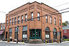 | November 2, 2000 (#00001312) | 100 N. Chester St. 40°29′54″N 80°36′35″W / 40.498333°N 80.609722°W / 40.498333; -80.609722 (First National Bank-Graham Building) | New Cumberland | |
2 | Johnston-Truax House |  | September 23, 1993 (#93000611) | 209 Seneca St. 40°25′34″N 80°33′27″W / 40.426111°N 80.557500°W / 40.426111; -80.557500 (Johnston-Truax House) | Weirton | |
3 | Marland Heights Park and Margaret Manson Weir Memorial Pool | 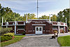 | November 15, 1993 (#93001230) | Junction of Williams Dr. and Riverview Dr. 40°24′14″N 80°35′59″W / 40.403889°N 80.599722°W / 40.403889; -80.599722 (Marland Heights Park and Margaret Manson Weir Memorial Pool) | Weirton | |
4 | Marshall House | 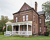 | March 12, 2001 (#01000263) | 1008 Ridge Ave. 40°29′47″N 80°36′16″W / 40.496389°N 80.604444°W / 40.496389; -80.604444 (Marshall House) | New Cumberland | |
5 | James F. Murray House |  | July 12, 1990 (#90001066) | 530 Louisiana Ave. 40°36′42″N 80°33′42″W / 40.611667°N 80.561667°W / 40.611667; -80.561667 (James F. Murray House) | Chester | Destroyed |
6 | People's Bank |  | March 17, 1995 (#95000253) | 3383 Main St. 40°24′05″N 80°35′03″W / 40.401389°N 80.584167°W / 40.401389; -80.584167 (People's Bank) | Weirton | |
7 | Dr. George Rigas House |  | April 21, 2004 (#04000358) | 3412 West St. 40°24′14″N 80°35′26″W / 40.403889°N 80.590556°W / 40.403889; -80.590556 (Dr. George Rigas House) | Weirton | |
8 | Peter Tarr Furnace Site |  | January 1, 1976 (#76001935) | Kings Creek Rd., north of Weirton[5] 40°26′15″N 80°34′22″W / 40.4374°N 80.5728°W / 40.4374; -80.5728 (Peter Tarr Furnace Site) | Weirton | |
9 | Waterford Park |  | December 12, 2002 (#02001528) | WV 2 40°34′49″N 80°39′42″W / 40.580278°N 80.661667°W / 40.580278; -80.661667 (Waterford Park) | Newell | |
10 | William E. Wells House | 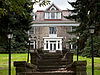 | April 23, 2009 (#09000244) | 372 Virginia Terr. 40°36′53″N 80°36′04″W / 40.614717°N 80.601053°W / 40.614717; -80.601053 (William E. Wells House) | Newell |
Former listing[edit]
| [3] | Name on the Register | Image | Date listed | Date removed | Location | City or town | Summary |
|---|---|---|---|---|---|---|---|
1 | Old Courthouse | July 2, 1973 (#73001902) | June 4, 1986 | High and Elm Streets 40°31′50″N 80°34′35″W / 40.5306°N 80.5764°W / 40.5306; -80.5764 (Old Courthouse) | New Manchester | Demolished |
See also[edit]
| Wikimedia Commons has media related to National Register of Historic Places in Hancock County, West Virginia. |
- List of National Historic Landmarks in West Virginia
- National Register of Historic Places listings in West Virginia
References[edit]
^ The latitude and longitude information provided in this table was derived originally from the National Register Information System, which has been found to be fairly accurate for about 99% of listings. For about 1% of NRIS original coordinates, experience has shown that one or both coordinates are typos or otherwise extremely far off; some corrections may have been made. A more subtle problem causes many locations to be off by up to 150 yards, depending on location in the country: most NRIS coordinates were derived from tracing out latitude and longitudes from USGS topographical quadrant maps created under the North American Datum of 1927, which differs from the current, highly accurate WGS84 GPS system used by most on-line maps. Chicago is about right, but NRIS longitudes in Washington are higher by about 4.5 seconds, and are lower by about 2.0 seconds in Maine. Latitudes differ by about 1.0 second in Florida. Some locations in this table may have been corrected to current GPS standards.
^ "National Register of Historic Places: Weekly List Actions". National Park Service, United States Department of the Interior. Retrieved on November 16, 2018.
^ ab Numbers represent an ordering by significant words. Various colorings, defined here, differentiate National Historic Landmarks and historic districts from other NRHP buildings, structures, sites or objects.
^ The eight-digit number below each date is the number assigned to each location in the National Register Information System database, which can be viewed by clicking the number.
^ Location derived from this online news story; the NRIS lists the site as "Address Restricted"
U.S. National Register of Historic Places in West Virginia | ||
|---|---|---|
| Topics |
|  |
| Lists by county |
| |
| Other lists |
| |
| ||
Municipalities and communities of Hancock County, West Virginia, United States | ||
|---|---|---|
County seat: New Cumberland | ||
| Cities |
|  |
| CDP |
| |
| Unincorporated communities |
| |
| Footnotes | ‡This populated place also has portions in an adjacent county or counties | |
Categories:
- National Register of Historic Places in Hancock County, West Virginia
- Lists of National Register of Historic Places in West Virginia by county
(window.RLQ=window.RLQ||).push(function(){mw.config.set({"wgPageParseReport":{"limitreport":{"cputime":"0.324","walltime":"0.422","ppvisitednodes":{"value":5164,"limit":1000000},"ppgeneratednodes":{"value":0,"limit":1500000},"postexpandincludesize":{"value":116669,"limit":2097152},"templateargumentsize":{"value":7518,"limit":2097152},"expansiondepth":{"value":10,"limit":40},"expensivefunctioncount":{"value":0,"limit":500},"unstrip-depth":{"value":0,"limit":20},"unstrip-size":{"value":3626,"limit":5000000},"entityaccesscount":{"value":1,"limit":400},"timingprofile":["100.00% 311.748 1 -total"," 47.65% 148.563 11 Template:NRHP_row"," 19.43% 60.588 1 Template:Commons_category"," 14.34% 44.701 12 Template:Dts"," 13.12% 40.907 25 Template:NRHP_color"," 11.94% 37.220 12 Template:Designation/color"," 9.39% 29.263 11 Template:Coord"," 9.04% 28.186 2 Template:Navbox"," 8.49% 26.472 1 Template:National_Register_of_Historic_Places_in_West_Virginia"," 8.28% 25.800 21 Template:First_word"]},"scribunto":{"limitreport-timeusage":{"value":"0.090","limit":"10.000"},"limitreport-memusage":{"value":2148059,"limit":52428800}},"cachereport":{"origin":"mw1323","timestamp":"20181122004815","ttl":1900800,"transientcontent":false}}});mw.config.set({"wgBackendResponseTime":529,"wgHostname":"mw1323"});});


