National Register of Historic Places listings in Preston County, West Virginia
National Register of Historic Places listings in Preston County, West Virginia
Jump to navigation
Jump to search
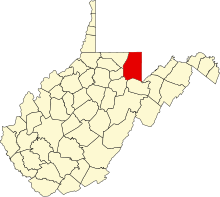
Location of Preston County in West Virginia
This is a list of the National Register of Historic Places listings in Preston County, West Virginia.
This is intended to be a complete list of the properties and districts on the National Register of Historic Places in Preston County, West Virginia. The locations of National Register properties and districts for which the latitude and longitude coordinates are included below, may be seen in a Google map.[1]
There are 21 properties and districts listed on the National Register in the county.
This National Park Service list is complete through NPS recent listings posted November 16, 2018.[2]
Barbour - |
Current listings[edit]
| [3] | Name on the Register[4] | Image | Date listed[5] | Location | City or town | Description |
|---|---|---|---|---|---|---|
1 | Arthurdale Historic District |  | February 1, 1989 (#88001862) | East and west of WV 92 39°29′34″N 79°49′01″W / 39.492778°N 79.816944°W / 39.492778; -79.816944 (Arthurdale Historic District) | Arthurdale | |
2 | Brookside Historic District |  | May 8, 2013 (#13000264) | George Washington Hwy. near Cathedral State Park 39°19′33″N 79°32′06″W / 39.325891°N 79.535138°W / 39.325891; -79.535138 (Brookside Historic District) | Aurora | |
3 | Col. Thomas Brown House | 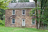 | March 17, 1994 (#94000212) | County Route 92/4 south of Reedsville 39°28′31″N 79°48′42″W / 39.475278°N 79.811667°W / 39.475278; -79.811667 (Col. Thomas Brown House) | Reedsville | |
4 | Coopers Rock State Forest Superintendent's House and Garage |  | May 15, 1991 (#91000546) | Off Interstate 68 8 mi (13 km) east of Morgantown 39°39′38″N 79°46′53″W / 39.660556°N 79.781389°W / 39.660556; -79.781389 (Coopers Rock State Forest Superintendent's House and Garage) | Morgantown | |
5 | Downtown Rowlesburg Historic District | 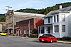 | November 30, 2005 (#05001350) | Buffalo St., Church St., portions of Main St., Poplar St., Railroad Alley and Railroad St. 39°20′50″N 79°40′14″W / 39.347222°N 79.670556°W / 39.347222; -79.670556 (Downtown Rowlesburg Historic District) | Rowlesburg | |
6 | Elkins Coal and Coke Company Historic District |  | July 1, 1983 (#83003249) | Off WV 7 39°32′42″N 79°48′36″W / 39.545°N 79.81°W / 39.545; -79.81 (Elkins Coal and Coke Company Historic District) | Bretz | |
7 | Fairfax Stone Site |  | January 26, 1970 (#70000653) | North of William at corner of Grant, Preston, and Tucker counties 39°11′42″N 79°29′16″W / 39.195°N 79.487778°W / 39.195; -79.487778 (Fairfax Stone Site) | Redhouse | |
8 | Gaymont |  | April 14, 1992 (#92000351) | U.S. Route 50 west of junction with WV 24 39°19′31″N 79°32′08″W / 39.325278°N 79.535556°W / 39.325278; -79.535556 (Gaymont) | Aurora | |
9 | A.W. Gribble Farm |  | December 30, 2009 (#09001192) | Loop Rd. 39°37′35″N 79°46′03″W / 39.62634°N 79.7674°W / 39.62634; -79.7674 (A.W. Gribble Farm) | Pisgah | |
10 | Hagans Homestead | 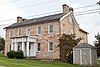 | July 14, 1993 (#93000617) | WV 26, 1 mile north of junction with Interstate 68 (Exit 23) 39°39′56″N 79°37′22″W / 39.665556°N 79.622778°W / 39.665556; -79.622778 (Hagans Homestead) | Brandonville | |
11 | Indian Rocks Dining Hall |  | January 8, 2003 (#02001688) | WV 7, 1 mile east of Reedsville 39°30′37″N 79°45′55″W / 39.510278°N 79.765278°W / 39.510278; -79.765278 (Indian Rocks Dining Hall) | Reedsville | |
12 | Kingwood Historic District |  | July 15, 1994 (#94000723) | Roughly bounded by Tunnelton, Main, Sigler, High, and Price Sts. and Brown Ave. 39°28′13″N 79°41′14″W / 39.470278°N 79.687222°W / 39.470278; -79.687222 (Kingwood Historic District) | Kingwood | |
13 | James S. Lakin House |  | January 9, 1997 (#96001573) | 102 Aurora Ave. 39°26′37″N 79°32′51″W / 39.4435°N 79.5475°W / 39.4435; -79.5475 (James S. Lakin House) | Terra Alta | |
14 | James Clark McGrew House |  | July 9, 1993 (#93000618) | 109 E. Main St. 39°28′20″N 79°41′11″W / 39.472222°N 79.686389°W / 39.472222; -79.686389 (James Clark McGrew House) | Kingwood | |
15 | Old Hemlock |  | December 16, 2014 (#14001061) | 17098 Brandonville Pike 39°38′54″N 79°37′02″W / 39.6483°N 79.6171°W / 39.6483; -79.6171 (Old Hemlock) | Bruceton Mills | |
16 | Ralphsynder Decagonal Barn | 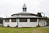 | December 2, 1985 (#85003111) | County Route 52/2 39°33′10″N 79°45′47″W / 39.5528°N 79.7631°W / 39.5528; -79.7631 (Ralphsynder Decagonal Barn) | Masontown | |
17 | Reckart Mill | 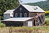 | June 3, 1980 (#80004039) | West of Cranesville at junction of WV 28 and County Route 47/2 39°33′12″N 79°31′41″W / 39.55328°N 79.52805°W / 39.55328; -79.52805 (Reckart Mill) | Cranesville | |
18 | Red Horse Tavern |  | July 2, 1973 (#73001923) | 1 mile east of Aurora on U.S. Route 50 39°19′35″N 79°31′54″W / 39.32645°N 79.5317°W / 39.32645; -79.5317 (Red Horse Tavern) | Aurora and Brookside | Boundaries increased on May 4, 1989 |
19 | Terra Alta Bank |  | July 9, 1997 (#97000786) | 109 E. Washington St. 39°26′42″N 79°32′45″W / 39.4449°N 79.5459°W / 39.4449; -79.5459 (Terra Alta Bank) | Terra Alta | |
20 | Tunnelton Railroad Depot |  | May 2, 1996 (#96000437) | Boswell St., north of the junction of Boswell and South Sts. 39°23′37″N 79°44′45″W / 39.393611°N 79.745833°W / 39.393611; -79.745833 (Tunnelton Railroad Depot) | Tunnelton | |
21 | Virginia Furnace |  | July 1, 1999 (#99000790) | WV 26, along Muddy Creek 39°31′45″N 79°38′00″W / 39.529167°N 79.633333°W / 39.529167; -79.633333 (Virginia Furnace) | Albright |
See also[edit]
| Wikimedia Commons has media related to National Register of Historic Places in Preston County, West Virginia. |
- List of National Historic Landmarks in West Virginia
- National Register of Historic Places listings in West Virginia
References[edit]
^ The latitude and longitude information provided in this table was derived originally from the National Register Information System, which has been found to be fairly accurate for about 99% of listings. For about 1% of NRIS original coordinates, experience has shown that one or both coordinates are typos or otherwise extremely far off; some corrections may have been made. A more subtle problem causes many locations to be off by up to 150 yards, depending on location in the country: most NRIS coordinates were derived from tracing out latitude and longitudes from USGS topographical quadrant maps created under the North American Datum of 1927, which differs from the current, highly accurate WGS84 GPS system used by most on-line maps. Chicago is about right, but NRIS longitudes in Washington are higher by about 4.5 seconds, and are lower by about 2.0 seconds in Maine. Latitudes differ by about 1.0 second in Florida. Some locations in this table may have been corrected to current GPS standards.
^ "National Register of Historic Places: Weekly List Actions". National Park Service, United States Department of the Interior. Retrieved on November 16, 2018.
^ Numbers represent an ordering by significant words. Various colorings, defined here, differentiate National Historic Landmarks and historic districts from other NRHP buildings, structures, sites or objects.
^ National Park Service (2008-04-24). "National Register Information System". National Register of Historic Places. National Park Service..mw-parser-output cite.citation{font-style:inherit}.mw-parser-output q{quotes:"""""""'""'"}.mw-parser-output code.cs1-code{color:inherit;background:inherit;border:inherit;padding:inherit}.mw-parser-output .cs1-lock-free a{background:url("//upload.wikimedia.org/wikipedia/commons/thumb/6/65/Lock-green.svg/9px-Lock-green.svg.png")no-repeat;background-position:right .1em center}.mw-parser-output .cs1-lock-limited a,.mw-parser-output .cs1-lock-registration a{background:url("//upload.wikimedia.org/wikipedia/commons/thumb/d/d6/Lock-gray-alt-2.svg/9px-Lock-gray-alt-2.svg.png")no-repeat;background-position:right .1em center}.mw-parser-output .cs1-lock-subscription a{background:url("//upload.wikimedia.org/wikipedia/commons/thumb/a/aa/Lock-red-alt-2.svg/9px-Lock-red-alt-2.svg.png")no-repeat;background-position:right .1em center}.mw-parser-output .cs1-subscription,.mw-parser-output .cs1-registration{color:#555}.mw-parser-output .cs1-subscription span,.mw-parser-output .cs1-registration span{border-bottom:1px dotted;cursor:help}.mw-parser-output .cs1-hidden-error{display:none;font-size:100%}.mw-parser-output .cs1-visible-error{font-size:100%}.mw-parser-output .cs1-subscription,.mw-parser-output .cs1-registration,.mw-parser-output .cs1-format{font-size:95%}.mw-parser-output .cs1-kern-left,.mw-parser-output .cs1-kern-wl-left{padding-left:0.2em}.mw-parser-output .cs1-kern-right,.mw-parser-output .cs1-kern-wl-right{padding-right:0.2em}
^ The eight-digit number below each date is the number assigned to each location in the National Register Information System database, which can be viewed by clicking the number.
U.S. National Register of Historic Places in West Virginia | ||
|---|---|---|
| Topics |
|  |
| Lists by county |
| |
| Other lists |
| |
| ||
Municipalities and communities of Preston County, West Virginia, United States | ||
|---|---|---|
County seat: Kingwood | ||
| City |
|  |
| Towns |
| |
| CDP |
| |
| Unincorporated communities |
| |
Categories:
- National Register of Historic Places in Preston County, West Virginia
- Lists of National Register of Historic Places in West Virginia by county
(window.RLQ=window.RLQ||).push(function(){mw.config.set({"wgPageParseReport":{"limitreport":{"cputime":"0.572","walltime":"0.739","ppvisitednodes":{"value":9237,"limit":1000000},"ppgeneratednodes":{"value":0,"limit":1500000},"postexpandincludesize":{"value":183763,"limit":2097152},"templateargumentsize":{"value":15758,"limit":2097152},"expansiondepth":{"value":11,"limit":40},"expensivefunctioncount":{"value":0,"limit":500},"unstrip-depth":{"value":1,"limit":20},"unstrip-size":{"value":5577,"limit":5000000},"entityaccesscount":{"value":1,"limit":400},"timingprofile":["100.00% 516.602 1 -total"," 45.76% 236.387 21 Template:NRHP_row"," 23.91% 123.514 1 Template:NRHP_header"," 19.35% 99.981 1 Template:NRISref"," 18.56% 95.881 1 Template:Cite_web"," 14.30% 73.851 1 Template:Commons_category"," 9.04% 46.690 22 Template:Designation/color"," 8.70% 44.947 42 Template:First_word"," 8.68% 44.839 21 Template:Coord"," 7.23% 37.328 22 Template:Dts"]},"scribunto":{"limitreport-timeusage":{"value":"0.203","limit":"10.000"},"limitreport-memusage":{"value":6542570,"limit":52428800}},"cachereport":{"origin":"mw1272","timestamp":"20181122004740","ttl":1900800,"transientcontent":false}}});mw.config.set({"wgBackendResponseTime":836,"wgHostname":"mw1272"});});


