List of bridges on the National Register of Historic Places in West Virginia
List of bridges on the National Register of Historic Places in West Virginia
Jump to navigation
Jump to search
This is a list of bridges and tunnels on the National Register of Historic Places in the U.S. state of West Virginia.[1]
| Name | Image | Built | Listed | Location | County | Type |
|---|---|---|---|---|---|---|
Alderson Bridge |  | 1914 | 1991-12-04 | Alderson 37°43′29″N 80°38′36″W / 37.72472°N 80.64333°W / 37.72472; -80.64333 (Alderson Bridge) | Greenbrier, Monroe | Concrete arch bridge |
B & O Railroad Potomac River Crossing |  | 1894, 1931 | 1978-02-14 | Harpers Ferry, West Virginia 39°19′27″N 77°43′43″W / 39.32417°N 77.72861°W / 39.32417; -77.72861 (B & O Railroad Potomac River Crossing) | Jefferson | |
Barrackville Covered Bridge |  | 1853 | 1973-03-30 | Barrackville 39°30′21″N 80°10′5″W / 39.50583°N 80.16806°W / 39.50583; -80.16806 (Barrackville Covered Bridge) | Marion | Covered Burr truss |
Bridgeport Lamp Chimney Company Bowstring Concrete Arch Bridge | 1924 | 1997-01-27 | Bridgeport 39°17′3″N 80°15′22″W / 39.28417°N 80.25611°W / 39.28417; -80.25611 (Bridgeport Lamp Chimney Company Bowstring Concrete Arch Bridge) | Harrison | Concrete Arch Bridge | |
Burnsville Bridge |  | 1893 | 1995-03-17 | Burnsville 38°51′19″N 80°39′25″W / 38.85528°N 80.65694°W / 38.85528; -80.65694 (Burnsville Bridge) | Braxton | Pratt-Through Truss |
Capon Lake Whipple Truss Bridge |  | 2011-12-11 | Capon Lake 39°9′28″N 78°32′13″W / 39.15778°N 78.53694°W / 39.15778; -78.53694 (Capon Lake Whipple Truss Bridge) | Hampshire | formerly South Branch Bridge | |
Carrollton Covered Bridge |  | 1856 | 1981-06-04 | Carrollton 39°5′24″N 80°5′12″W / 39.09000°N 80.08667°W / 39.09000; -80.08667 (Carrollton Covered Bridge) | Barbour | Covered Burr Arch |
Center Point Covered Bridge |  | 1983-08-29 | Center Point 39°23′22″N 80°38′4″W / 39.38944°N 80.63444°W / 39.38944; -80.63444 (Center Point Covered Bridge) | Doddridge | Covered bridge | |
Dents Run Covered Bridge |  | 1889 | 1981-06-04 | Laurel Point 39°37′26″N 80°2′24″W / 39.62389°N 80.04000°W / 39.62389; -80.04000 (Dents Run Covered Bridge) | Monongalia | Covered Kingpost Truss |
Duck Run Cable Suspension Bridge | 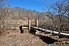 | 1922 | 1997-07-09 | Trubada 38°55′38″N 80°47′28″W / 38.92722°N 80.79111°W / 38.92722; -80.79111 (Duck Run Cable Suspension Bridge) | Gilmer | cable suspension bridge |
Elm Grove Stone Arch Bridge |  | 1817 | 1981-08-21 | Wheeling 40°2′37″N 80°39′32″W / 40.04361°N 80.65889°W / 40.04361; -80.65889 (Elm Grove Stone Arch Bridge) | Ohio | Stone Arch |
Fish Creek Covered Bridge |  | ca. 1881 | 1981-06-04 | Hundred 39°40′20″N 80°27′9″W / 39.67222°N 80.45250°W / 39.67222; -80.45250 (Fish Creek Covered Bridge) | Wetzel | Covered King Post truss |
Fletcher Covered Bridge | 1891 | 1981-06-04 | Maken 39°18′20″N 80°28′49″W / 39.30556°N 80.48028°W / 39.30556; -80.48028 (Fletcher Covered Bridge) | Harrison | Covered Kingpost Truss | |
Glenville Truss Bridge |  | 1885 | 1998-12-04 | Glenville 38°55′58″N 80°50′20″W / 38.93278°N 80.83889°W / 38.93278; -80.83889 (Glenville Truss Bridge) | Gilmer | Pratt Through Truss |
Herns Mill Covered Bridge | 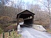 | 1884 | 1981-06-04 | Lewisburg 37°49′57″N 80°30′18″W / 37.83250°N 80.50500°W / 37.83250; -80.50500 (Herns Mill Covered Bridge) | Greenbrier | Covered Queen Post Truss |
High Level Bridge |  | 1921 | 1991-12-04 | Fairmont 39°28′57″N 80°8′27″W / 39.48250°N 80.14083°W / 39.48250; -80.14083 (High Level Bridge) | Marion | |
Hokes Mill Covered Bridge |  | ca. 1899 | 1981-06-04 | Lewisburg 37°41′50″N 80°31′30″W / 37.69722°N 80.52500°W / 37.69722; -80.52500 (Hokes Mill Covered Bridge) | Greenbrier | Covered Long Truss |
Indian Creek Covered Bridge |  | ca. 1898 | 1975-04-01 | Salt Sulphur Springs 37°32′50″N 80°34′22″W / 37.54722°N 80.57278°W / 37.54722; -80.57278 (Indian Creek Covered Bridge) | Monroe | Covered Howe Truss |
Laurel Creek Covered Bridge |  | 1910, 1911 | 1981-06-04 | Lillydale 37°33′40″N 80°37′36″W / 37.56111°N 80.62667°W / 37.56111; -80.62667 (Laurel Creek Covered Bridge) | Monroe | Covered |
Locust Creek Covered Bridge | 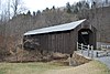 | 1870 | 1981-06-04 | Hillsboro 38°4′46″N 80°15′1″W / 38.07944°N 80.25028°W / 38.07944; -80.25028 (Locust Creek Covered Bridge) | Pocahontas | Covered Warren Truss |
Mud River Covered Bridge | 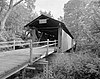 | ca. 1875 | 1975-06-10 | Milton 38°25′51″N 82°8′22″W / 38.43083°N 82.13944°W / 38.43083; -82.13944 (Mud River Covered Bridge) | Cabell | Covered Modified Howe truss |
New River Gorge Bridge | 1977 | 2013-08-14 | near Fayetteville | Fayette | Steel arch | |
Parks's Gap Bridge | 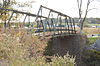 | 1892 | 1994-11-04 | Martinsburg 39°30′45″N 78°2′11″W / 39.51250°N 78.03639°W / 39.51250; -78.03639 (Parks's Gap Bridge) | Berkeley | Modified Howe Truss |
Philippi Covered Bridge |  | 1852 | 1972-09-14 | Philippi 39°9′11″N 80°2′37″W / 39.15306°N 80.04361°W / 39.15306; -80.04361 (Philippi Covered Bridge) | Barbour | Covered |
Rotary Park Bridge | 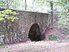 | 1929, 1930 | 2002-12-12 | Huntington 38°25′7″N 82°23′39″W / 38.41861°N 82.39417°W / 38.41861; -82.39417 (Rotary Park Bridge) | Cabell | Rustic |
Sarvis Fork Covered Bridge |  | 1889, 1890 | 1981-06-04 | Sandyville 38°55′17″N 81°38′41″W / 38.92139°N 81.64472°W / 38.92139; -81.64472 (Sarvis Fork Covered Bridge) | Jackson | Covered Long Truss |
Simpson Creek Covered Bridge | 1881 | 1981-06-04 | Bridgeport 39°18′31″N 80°16′47″W / 39.30861°N 80.27972°W / 39.30861; -80.27972 (Simpson Creek Covered Bridge) | Harrison | Covered Multiple Kingpost | |
Sixth Street Railroad Bridge |  | 1869, 1871, 1914 | 1982-12-10 | Parkersburg 39°16′2″N 81°33′32″W / 39.26722°N 81.55889°W / 39.26722; -81.55889 (Sixth Street Railroad Bridge) | Wood | |
Staats Mill Covered Bridge |  | 1887 | 1979-05-29 | Staats Mill 38°44′34″N 81°37′34″W / 38.74278°N 81.62611°W / 38.74278; -81.62611 (Staats Mill Covered Bridge) | Jackson | Covered Long truss |
Stouts Mill Bridge | 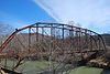 | 1897 | 1998-12-04 | Stouts Mill 38°53′47″N 80°43′54″W / 38.89639°N 80.73167°W / 38.89639; -80.73167 (Stouts Mill Bridge) | Gilmer | camel-back through truss |
Van Metre Ford Stone Bridge |  | 1832 | 1977-08-22 | Martinsburg 39°26′42″N 77°55′40″W / 39.44500°N 77.92778°W / 39.44500; -77.92778 (Van Metre Ford Stone Bridge) | Berkeley | Stone Arch |
Walkersville Covered Bridge |  | 1903 | 1981-06-04 | Walkersville 38°51′30″N 80°27′39″W / 38.85833°N 80.46083°W / 38.85833; -80.46083 (Walkersville Covered Bridge) | Lewis | Covered Queenpost Truss |
Wheeling Suspension Bridge | 1849 | 1970-01-26 | Wheeling 40°4′13″N 80°43′38″W / 40.07028°N 80.72722°W / 40.07028; -80.72722 (Wheeling Suspension Bridge) | Ohio | Suspension;Howe truss | |
Winfield Toll Bridge | 2011-12-15 | Winfield 38°32′4″N 81°53′53″W / 38.53444°N 81.89806°W / 38.53444; -81.89806 (Winfield Toll Bridge) | Putnam |
References[edit]
^ National Park Service (2010-07-09). "National Register Information System". National Register of Historic Places. National Park Service..mw-parser-output cite.citation{font-style:inherit}.mw-parser-output q{quotes:"""""""'""'"}.mw-parser-output code.cs1-code{color:inherit;background:inherit;border:inherit;padding:inherit}.mw-parser-output .cs1-lock-free a{background:url("//upload.wikimedia.org/wikipedia/commons/thumb/6/65/Lock-green.svg/9px-Lock-green.svg.png")no-repeat;background-position:right .1em center}.mw-parser-output .cs1-lock-limited a,.mw-parser-output .cs1-lock-registration a{background:url("//upload.wikimedia.org/wikipedia/commons/thumb/d/d6/Lock-gray-alt-2.svg/9px-Lock-gray-alt-2.svg.png")no-repeat;background-position:right .1em center}.mw-parser-output .cs1-lock-subscription a{background:url("//upload.wikimedia.org/wikipedia/commons/thumb/a/aa/Lock-red-alt-2.svg/9px-Lock-red-alt-2.svg.png")no-repeat;background-position:right .1em center}.mw-parser-output .cs1-subscription,.mw-parser-output .cs1-registration{color:#555}.mw-parser-output .cs1-subscription span,.mw-parser-output .cs1-registration span{border-bottom:1px dotted;cursor:help}.mw-parser-output .cs1-hidden-error{display:none;font-size:100%}.mw-parser-output .cs1-visible-error{font-size:100%}.mw-parser-output .cs1-subscription,.mw-parser-output .cs1-registration,.mw-parser-output .cs1-format{font-size:95%}.mw-parser-output .cs1-kern-left,.mw-parser-output .cs1-kern-wl-left{padding-left:0.2em}.mw-parser-output .cs1-kern-right,.mw-parser-output .cs1-kern-wl-right{padding-right:0.2em}
Categories:
- Bridges on the National Register of Historic Places in West Virginia
- Lists of bridges on the National Register of Historic Places by state
- West Virginia transportation-related lists
- Lists of buildings and structures in West Virginia
(window.RLQ=window.RLQ||).push(function(){mw.config.set({"wgPageParseReport":{"limitreport":{"cputime":"0.472","walltime":"0.586","ppvisitednodes":{"value":1973,"limit":1000000},"ppgeneratednodes":{"value":0,"limit":1500000},"postexpandincludesize":{"value":82556,"limit":2097152},"templateargumentsize":{"value":254,"limit":2097152},"expansiondepth":{"value":8,"limit":40},"expensivefunctioncount":{"value":0,"limit":500},"unstrip-depth":{"value":1,"limit":20},"unstrip-size":{"value":2703,"limit":5000000},"entityaccesscount":{"value":0,"limit":400},"timingprofile":["100.00% 256.655 1 -total"," 40.07% 102.832 1 Template:Reflist"," 34.63% 88.880 33 Template:Coord"," 34.45% 88.407 1 Template:NRISref"," 32.62% 83.726 1 Template:Cite_web"," 9.43% 24.191 1 Template:NRHP_bridges"," 8.01% 20.558 1 Template:Navbox"," 7.03% 18.047 7 Template:NRHP_color"," 5.86% 15.046 1 Template:Designation/color"," 3.82% 9.793 4 Template:Sort"]},"scribunto":{"limitreport-timeusage":{"value":"0.123","limit":"10.000"},"limitreport-memusage":{"value":1709554,"limit":52428800}},"cachereport":{"origin":"mw1240","timestamp":"20181116220100","ttl":1900800,"transientcontent":false}}});});{"@context":"https://schema.org","@type":"Article","name":"List of bridges on the National Register of Historic Places in West Virginia","url":"https://en.wikipedia.org/wiki/List_of_bridges_on_the_National_Register_of_Historic_Places_in_West_Virginia","sameAs":"http://www.wikidata.org/entity/Q6608290","mainEntity":"http://www.wikidata.org/entity/Q6608290","author":{"@type":"Organization","name":"Contributors to Wikimedia projects"},"publisher":{"@type":"Organization","name":"Wikimedia Foundation, Inc.","logo":{"@type":"ImageObject","url":"https://www.wikimedia.org/static/images/wmf-hor-googpub.png"}},"datePublished":"2008-05-06T08:22:27Z","dateModified":"2018-10-12T07:35:02Z","headline":"Wikimedia list article"}(window.RLQ=window.RLQ||).push(function(){mw.config.set({"wgBackendResponseTime":95,"wgHostname":"mw1264"});});


