National Register of Historic Places listings in Mineral County, West Virginia
National Register of Historic Places listings in Mineral County, West Virginia
Jump to navigation
Jump to search

Location of Mineral County in West Virginia
This is a list of the National Register of Historic Places listings in Mineral County, West Virginia.
This is intended to be a complete list of the properties and districts on the National Register of Historic Places in Mineral County, West Virginia, United States. The locations of National Register properties and districts for which the latitude and longitude coordinates are included below, may be seen in a Google map.[1]
There are 11 properties and districts listed on the National Register in the county.
This National Park Service list is complete through NPS recent listings posted November 16, 2018.[2]
Barbour - |
Current listings[edit]
| [3] | Name on the Register[4] | Image | Date listed[5] | Location | City or town | Description |
|---|---|---|---|---|---|---|
1 | Burlington Historic District |  | December 7, 1992 (#92001660) | County Route 11 south from its junction with U.S. Routes 50/220 39°20′09″N 78°55′06″W / 39.335833°N 78.918333°W / 39.335833; -78.918333 (Burlington Historic District) | Burlington | |
2 | Carskadon House |  | March 20, 1987 (#87000487) | Route 1, Box 93A, Beaver Run Rd. 39°23′22″N 78°51′01″W / 39.389444°N 78.850278°W / 39.389444; -78.850278 (Carskadon House) | Burlington | |
3 | Thomas R. Carskadon House |  | August 22, 2002 (#02000900) | Carskadon Rd. 39°25′53″N 78°59′15″W / 39.431389°N 78.987500°W / 39.431389; -78.987500 (Thomas R. Carskadon House) | Keyser | |
4 | Henry Gassaway Davis House | 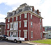 | December 17, 2008 (#08001239) | 15-17 Jones St. 39°28′55″N 79°02′56″W / 39.4820°N 79.0490°W / 39.4820; -79.0490 (Henry Gassaway Davis House) | Piedmont | |
5 | Fairview | December 7, 1992 (#92001631) | Junction of Patterson Creek Dr. and Russelldale Rds. 39°17′59″N 78°56′11″W / 39.299722°N 78.936389°W / 39.299722; -78.936389 (Fairview) | Burlington | ||
6 | Fort Ashby |  | December 18, 1970 (#70000657) | South St. 39°30′19″N 78°45′57″W / 39.505278°N 78.765833°W / 39.505278; -78.765833 (Fort Ashby) | Fort Ashby | |
7 | Fort Hill |  | January 9, 1997 (#96001569) | Patterson Creek Rd., approximately 1.5 mi (2.4 km) south of junction with U.S. Routes 50/220 39°18′37″N 78°56′08″W / 39.310278°N 78.935556°W / 39.310278; -78.935556 (Fort Hill) | Burlington | |
8 | Mineral County Courthouse |  | September 7, 2005 (#05001005) | 150 Armstrong St. 39°26′24″N 78°58′24″W / 39.440000°N 78.973333°W / 39.440000; -78.973333 (Mineral County Courthouse) | Keyser | |
9 | Stewart's Tavern |  | July 14, 2000 (#00000776) | Short Gap Rd. 39°32′38″N 78°48′44″W / 39.543889°N 78.812222°W / 39.543889; -78.812222 (Stewart's Tavern) | Short Gap | |
10 | Travelers Rest |  | July 26, 2006 (#06000655) | 1 mi (1.6 km) east of Ridgeville on U.S. Route 50 39°20′25″N 78°58′37″W / 39.340278°N 78.976917°W / 39.340278; -78.976917 (Travelers Rest) | Burlington | |
11 | Vandiver-Trout-Clause House |  | May 29, 1979 (#79002592) | U.S. Routes 50/220 39°20′59″N 78°59′33″W / 39.349722°N 78.992500°W / 39.349722; -78.992500 (Vandiver-Trout-Clause House) | Ridgeville |
See also[edit]
| Wikimedia Commons has media related to National Register of Historic Places in Mineral County, West Virginia. |
- List of National Historic Landmarks in West Virginia
- National Register of Historic Places listings in West Virginia
References[edit]
^ The latitude and longitude information provided in this table was derived originally from the National Register Information System, which has been found to be fairly accurate for about 99% of listings. For about 1% of NRIS original coordinates, experience has shown that one or both coordinates are typos or otherwise extremely far off; some corrections may have been made. A more subtle problem causes many locations to be off by up to 150 yards, depending on location in the country: most NRIS coordinates were derived from tracing out latitude and longitudes from USGS topographical quadrant maps created under the North American Datum of 1927, which differs from the current, highly accurate WGS84 GPS system used by most on-line maps. Chicago is about right, but NRIS longitudes in Washington are higher by about 4.5 seconds, and are lower by about 2.0 seconds in Maine. Latitudes differ by about 1.0 second in Florida. Some locations in this table may have been corrected to current GPS standards.
^ "National Register of Historic Places: Weekly List Actions". National Park Service, United States Department of the Interior. Retrieved on November 16, 2018.
^ Numbers represent an ordering by significant words. Various colorings, defined here, differentiate National Historic Landmarks and historic districts from other NRHP buildings, structures, sites or objects.
^ National Park Service (2008-04-24). "National Register Information System". National Register of Historic Places. National Park Service..mw-parser-output cite.citation{font-style:inherit}.mw-parser-output q{quotes:"""""""'""'"}.mw-parser-output code.cs1-code{color:inherit;background:inherit;border:inherit;padding:inherit}.mw-parser-output .cs1-lock-free a{background:url("//upload.wikimedia.org/wikipedia/commons/thumb/6/65/Lock-green.svg/9px-Lock-green.svg.png")no-repeat;background-position:right .1em center}.mw-parser-output .cs1-lock-limited a,.mw-parser-output .cs1-lock-registration a{background:url("//upload.wikimedia.org/wikipedia/commons/thumb/d/d6/Lock-gray-alt-2.svg/9px-Lock-gray-alt-2.svg.png")no-repeat;background-position:right .1em center}.mw-parser-output .cs1-lock-subscription a{background:url("//upload.wikimedia.org/wikipedia/commons/thumb/a/aa/Lock-red-alt-2.svg/9px-Lock-red-alt-2.svg.png")no-repeat;background-position:right .1em center}.mw-parser-output .cs1-subscription,.mw-parser-output .cs1-registration{color:#555}.mw-parser-output .cs1-subscription span,.mw-parser-output .cs1-registration span{border-bottom:1px dotted;cursor:help}.mw-parser-output .cs1-hidden-error{display:none;font-size:100%}.mw-parser-output .cs1-visible-error{font-size:100%}.mw-parser-output .cs1-subscription,.mw-parser-output .cs1-registration,.mw-parser-output .cs1-format{font-size:95%}.mw-parser-output .cs1-kern-left,.mw-parser-output .cs1-kern-wl-left{padding-left:0.2em}.mw-parser-output .cs1-kern-right,.mw-parser-output .cs1-kern-wl-right{padding-right:0.2em}
^ The eight-digit number below each date is the number assigned to each location in the National Register Information System database, which can be viewed by clicking the number.
U.S. National Register of Historic Places in West Virginia | ||
|---|---|---|
| Topics |
|  |
| Lists by county |
| |
| Other lists |
| |
| ||
Municipalities and communities of Mineral County, West Virginia, United States | ||
|---|---|---|
County seat: Keyser | ||
| City |
|  |
| Towns |
| |
| CDPs |
| |
| Other localities |
| |
| Ghost towns |
| |
| Footnotes | ‡This populated place also has portions in an adjacent county or counties | |
Categories:
- National Register of Historic Places in Mineral County, West Virginia
- Lists of National Register of Historic Places in West Virginia by county
(window.RLQ=window.RLQ||).push(function(){mw.config.set({"wgPageParseReport":{"limitreport":{"cputime":"0.424","walltime":"0.583","ppvisitednodes":{"value":5349,"limit":1000000},"ppgeneratednodes":{"value":0,"limit":1500000},"postexpandincludesize":{"value":123229,"limit":2097152},"templateargumentsize":{"value":8506,"limit":2097152},"expansiondepth":{"value":11,"limit":40},"expensivefunctioncount":{"value":0,"limit":500},"unstrip-depth":{"value":1,"limit":20},"unstrip-size":{"value":5497,"limit":5000000},"entityaccesscount":{"value":1,"limit":400},"timingprofile":["100.00% 463.949 1 -total"," 36.08% 167.379 11 Template:NRHP_row"," 27.09% 125.673 1 Template:NRHP_header"," 21.88% 101.529 1 Template:NRISref"," 20.55% 95.353 1 Template:Cite_web"," 16.79% 77.917 1 Template:Commons_category"," 8.08% 37.464 2 Template:Convert"," 7.63% 35.412 2 Template:Navbox"," 7.49% 34.734 1 Template:National_Register_of_Historic_Places_in_West_Virginia"," 7.24% 33.581 12 Template:Designation/color"]},"scribunto":{"limitreport-timeusage":{"value":"0.167","limit":"10.000"},"limitreport-memusage":{"value":5214964,"limit":52428800}},"cachereport":{"origin":"mw1265","timestamp":"20181122004751","ttl":1900800,"transientcontent":false}}});mw.config.set({"wgBackendResponseTime":692,"wgHostname":"mw1265"});});


