National Register of Historic Places listings in Barbour County, West Virginia
National Register of Historic Places listings in Barbour County, West Virginia
Jump to navigation
Jump to search

Location of Barbour County in West Virginia
This is a list of the National Register of Historic Places listings in Barbour County, West Virginia.
This is intended to be a complete list of the properties and districts on the National Register of Historic Places in Barbour County, West Virginia, United States. The locations of National Register properties and districts for which the latitude and longitude coordinates are included below, may be seen in a Google map.[1]
There are 10 properties and districts listed on the National Register in the county.
This National Park Service list is complete through NPS recent listings posted November 16, 2018.[2]
Barbour - |
Current listings[edit]
| [3] | Name on the Register[4] | Image | Date listed[5] | Location | City or town | Description |
|---|---|---|---|---|---|---|
1 | Adaland |  | April 14, 1995 (#95000419) | County Route 77/5 off WV 76 at Fox Grape Run 39°12′04″N 80°04′13″W / 39.201111°N 80.070278°W / 39.201111; -80.070278 (Adaland) | Berryburg | |
2 | Barbour County Courthouse | 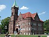 | February 22, 1980 (#80004014) | Court Sq. 39°09′09″N 80°02′22″W / 39.1525°N 80.039444°W / 39.1525; -80.039444 (Barbour County Courthouse) | Philippi | |
3 | Carrollton Covered Bridge |  | June 4, 1981 (#81000595) | County Route 36 39°05′24″N 80°05′12″W / 39.09°N 80.086667°W / 39.09; -80.086667 (Carrollton Covered Bridge) | Carrollton | |
4 | J.N.B. Crim House |  | August 24, 1984 (#84003462) | WV 57 39°08′38″N 80°07′09″W / 39.143889°N 80.119167°W / 39.143889; -80.119167 (J.N.B. Crim House) | Elk City | |
5 | Peck-Crim-Chesser House |  | August 23, 1984 (#84003464) | 14 N. Walnut St. 39°09′12″N 80°02′21″W / 39.153333°N 80.039167°W / 39.153333; -80.039167 (Peck-Crim-Chesser House) | Philippi | |
6 | Philippi B & O Railroad Station |  | May 16, 1986 (#86001082) | 146 N. Main St. 39°09′12″N 80°02′35″W / 39.153333°N 80.043056°W / 39.153333; -80.043056 (Philippi B & O Railroad Station) | Philippi | |
7 | Philippi Covered Bridge |  | September 14, 1972 (#72001284) | U.S. Route 250 at its junction with U.S. Route 119 39°09′11″N 80°02′37″W / 39.153056°N 80.043611°W / 39.153056; -80.043611 (Philippi Covered Bridge) | Philippi | |
8 | Philippi Historic District |  | August 29, 1990 (#90001241) | Roughly bounded by Pike, High, Walnut, Wolfe, Main, and Wilson Sts., and the Tygart Valley River 39°09′00″N 80°02′20″W / 39.15°N 80.038889°W / 39.15; -80.038889 (Philippi Historic District) | Philippi | |
9 | Whitescarver Hall |  | February 5, 1990 (#89002317) | Circle Dr. on the Alderson Broaddus University campus 39°09′36″N 80°02′26″W / 39.16°N 80.040556°W / 39.16; -80.040556 (Whitescarver Hall) | Philippi | |
10 | Bernard E. Wilmoth House |  | November 30, 2005 (#05001348) | 303 Dayton Boulevard 39°01′45″N 79°56′19″W / 39.029167°N 79.938611°W / 39.029167; -79.938611 (Bernard E. Wilmoth House) | Belington |
See also[edit]
| Wikimedia Commons has media related to National Register of Historic Places in Barbour County, West Virginia. |
- List of National Historic Landmarks in West Virginia
- National Register of Historic Places listings in West Virginia
References[edit]
^ The latitude and longitude information provided in this table was derived originally from the National Register Information System, which has been found to be fairly accurate for about 99% of listings. For about 1% of NRIS original coordinates, experience has shown that one or both coordinates are typos or otherwise extremely far off; some corrections may have been made. A more subtle problem causes many locations to be off by up to 150 yards, depending on location in the country: most NRIS coordinates were derived from tracing out latitude and longitudes from USGS topographical quadrant maps created under the North American Datum of 1927, which differs from the current, highly accurate WGS84 GPS system used by most on-line maps. Chicago is about right, but NRIS longitudes in Washington are higher by about 4.5 seconds, and are lower by about 2.0 seconds in Maine. Latitudes differ by about 1.0 second in Florida. Some locations in this table may have been corrected to current GPS standards.
^ "National Register of Historic Places: Weekly List Actions". National Park Service, United States Department of the Interior. Retrieved on November 16, 2018.
^ Numbers represent an ordering by significant words. Various colorings, defined here, differentiate National Historic Landmarks and historic districts from other NRHP buildings, structures, sites or objects.
^ National Park Service (2008-04-24). "National Register Information System". National Register of Historic Places. National Park Service..mw-parser-output cite.citation{font-style:inherit}.mw-parser-output q{quotes:"""""""'""'"}.mw-parser-output code.cs1-code{color:inherit;background:inherit;border:inherit;padding:inherit}.mw-parser-output .cs1-lock-free a{background:url("//upload.wikimedia.org/wikipedia/commons/thumb/6/65/Lock-green.svg/9px-Lock-green.svg.png")no-repeat;background-position:right .1em center}.mw-parser-output .cs1-lock-limited a,.mw-parser-output .cs1-lock-registration a{background:url("//upload.wikimedia.org/wikipedia/commons/thumb/d/d6/Lock-gray-alt-2.svg/9px-Lock-gray-alt-2.svg.png")no-repeat;background-position:right .1em center}.mw-parser-output .cs1-lock-subscription a{background:url("//upload.wikimedia.org/wikipedia/commons/thumb/a/aa/Lock-red-alt-2.svg/9px-Lock-red-alt-2.svg.png")no-repeat;background-position:right .1em center}.mw-parser-output .cs1-subscription,.mw-parser-output .cs1-registration{color:#555}.mw-parser-output .cs1-subscription span,.mw-parser-output .cs1-registration span{border-bottom:1px dotted;cursor:help}.mw-parser-output .cs1-hidden-error{display:none;font-size:100%}.mw-parser-output .cs1-visible-error{font-size:100%}.mw-parser-output .cs1-subscription,.mw-parser-output .cs1-registration,.mw-parser-output .cs1-format{font-size:95%}.mw-parser-output .cs1-kern-left,.mw-parser-output .cs1-kern-wl-left{padding-left:0.2em}.mw-parser-output .cs1-kern-right,.mw-parser-output .cs1-kern-wl-right{padding-right:0.2em}
^ The eight-digit number below each date is the number assigned to each location in the National Register Information System database, which can be viewed by clicking the number.
U.S. National Register of Historic Places in West Virginia | ||
|---|---|---|
| Topics |
|  |
| Lists by county |
| |
| Other lists |
| |
| ||
Municipalities and communities of Barbour County, West Virginia, United States | ||
|---|---|---|
County seat: Philippi | ||
| City |
|  |
| Magisterial districts |
| |
| Towns |
| |
| CDPs |
| |
| Unincorporated communities |
| |
Categories:
- National Register of Historic Places in Barbour County, West Virginia
- Lists of National Register of Historic Places in West Virginia by county
(window.RLQ=window.RLQ||).push(function(){mw.config.set({"wgPageParseReport":{"limitreport":{"cputime":"0.416","walltime":"0.563","ppvisitednodes":{"value":4916,"limit":1000000},"ppgeneratednodes":{"value":0,"limit":1500000},"postexpandincludesize":{"value":123560,"limit":2097152},"templateargumentsize":{"value":9675,"limit":2097152},"expansiondepth":{"value":11,"limit":40},"expensivefunctioncount":{"value":0,"limit":500},"unstrip-depth":{"value":1,"limit":20},"unstrip-size":{"value":5489,"limit":5000000},"entityaccesscount":{"value":1,"limit":400},"timingprofile":["100.00% 424.068 1 -total"," 40.95% 173.653 10 Template:NRHP_row"," 23.67% 100.396 1 Template:NRHP_header"," 18.65% 79.080 1 Template:NRISref"," 17.57% 74.521 1 Template:Cite_web"," 17.52% 74.313 1 Template:Commons_category"," 9.18% 38.931 16 Template:NRHP_color"," 8.92% 37.832 10 Template:Coord"," 8.84% 37.487 11 Template:Designation/color"," 8.54% 36.209 10 Template:Dts"]},"scribunto":{"limitreport-timeusage":{"value":"0.140","limit":"10.000"},"limitreport-memusage":{"value":3580204,"limit":52428800}},"cachereport":{"origin":"mw1242","timestamp":"20181122043603","ttl":1900800,"transientcontent":false}}});});{"@context":"https://schema.org","@type":"Article","name":"National Register of Historic Places listings in Barbour County, West Virginia","url":"https://en.wikipedia.org/wiki/National_Register_of_Historic_Places_listings_in_Barbour_County,_West_Virginia","sameAs":"http://www.wikidata.org/entity/Q12062474","mainEntity":"http://www.wikidata.org/entity/Q12062474","author":{"@type":"Organization","name":"Contributors to Wikimedia projects"},"publisher":{"@type":"Organization","name":"Wikimedia Foundation, Inc.","logo":{"@type":"ImageObject","url":"https://www.wikimedia.org/static/images/wmf-hor-googpub.png"}},"datePublished":"2010-04-16T18:55:32Z","dateModified":"2016-06-11T14:29:55Z","image":"https://upload.wikimedia.org/wikipedia/commons/8/88/Map_of_West_Virginia_highlighting_Barbour_County.svg","headline":"Wikimedia list article"}(window.RLQ=window.RLQ||).push(function(){mw.config.set({"wgBackendResponseTime":93,"wgHostname":"mw1240"});});


