National Register of Historic Places listings in Kanawha County, West Virginia
National Register of Historic Places listings in Kanawha County, West Virginia
Jump to navigation
Jump to search
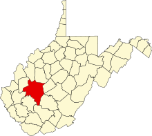
Location of Kanawha County in West Virginia
This is a list of the National Register of Historic Places listings in Kanawha County, West Virginia.
This is intended to be a complete list of the properties and districts on the National Register of Historic Places in Kanawha County, West Virginia, United States. The locations of National Register properties and districts for which the latitude and longitude coordinates are included below, may be seen in a Google map.[1]
There are 82 properties and districts listed on the National Register in the county.
This National Park Service list is complete through NPS recent listings posted November 16, 2018.[2]
Barbour - |
Current listings[edit]
| [3] | Name on the Register | Image | Date listed[4] | Location | City or town | Description |
|---|---|---|---|---|---|---|
1 | African Zion Baptist Church |  | December 27, 1974 (#74002010) | 4104 Malden Dr. 38°17′58″N 81°33′26″W / 38.299444°N 81.557222°W / 38.299444; -81.557222 (African Zion Baptist Church) | Malden | |
2 | Bank of St. Albans Building |  | February 1, 1988 (#87002518) | 80 Olde Main Plaza 38°23′11″N 81°50′21″W / 38.386389°N 81.839167°W / 38.386389; -81.839167 (Bank of St. Albans Building) | St. Albans | |
3 | Barnes-Wellford House |  | October 26, 1984 (#84000390) | 66 Abney Circle 38°20′18″N 81°38′28″W / 38.338333°N 81.641111°W / 38.338333; -81.641111 (Barnes-Wellford House) | Charleston | |
4 | The Beeches |  | April 20, 1979 (#79002586) | 805 Kanawha Ter. 38°22′55″N 81°49′49″W / 38.381944°N 81.830278°W / 38.381944; -81.830278 (The Beeches) | St. Albans | |
5 | Bird Haven |  | October 26, 1984 (#84000393) | 733 Myrtle Rd. 38°20′12″N 81°38′35″W / 38.336667°N 81.643056°W / 38.336667; -81.643056 (Bird Haven) | Charleston | |
6 | Daniel Boone Hotel |  | August 21, 1984 (#84003602) | 405 Capitol St. 38°21′05″N 81°37′56″W / 38.351389°N 81.632222°W / 38.351389; -81.632222 (Daniel Boone Hotel) | Charleston | |
7 | Bougemont Complex |  | October 26, 1984 (#84000395) | Bougemont Dr. 38°20′25″N 81°38′03″W / 38.340278°N 81.634167°W / 38.340278; -81.634167 (Bougemont Complex) | Charleston | |
8 | Breezemont |  | April 15, 1982 (#82004324) | 915 Breezemont Dr. 38°21′48″N 81°38′16″W / 38.363333°N 81.637778°W / 38.363333; -81.637778 (Breezemont) | Charleston | |
9 | Briarwood |  | October 26, 1984 (#84000396) | 1240 Staunton Rd. 38°20′13″N 81°38′07″W / 38.336944°N 81.635278°W / 38.336944; -81.635278 (Briarwood) | Charleston | |
10 | Canty House |  | September 23, 1988 (#88001587) | WV 25 38°22′57″N 81°45′48″W / 38.3825°N 81.763333°W / 38.3825; -81.763333 (Canty House) | Institute | |
11 | Cedar Grove | 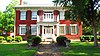 | March 10, 1975 (#75001893) | Southeast of the junction of U.S. Route 60 and Kanawha and James River Turnpike 38°13′17″N 81°25′41″W / 38.221389°N 81.428056°W / 38.221389; -81.428056 (Cedar Grove) | Cedar Grove | |
12 | Charleston Baptist Temple |  | April 4, 2000 (#00000252) | 209 Morris St. 38°20′43″N 81°37′44″W / 38.345278°N 81.628889°W / 38.345278; -81.628889 (Charleston Baptist Temple) | Charleston | |
13 | Charleston City Hall | 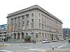 | June 6, 1988 (#88000639) | Court and Virginia Sts. 38°21′02″N 81°38′20″W / 38.350556°N 81.638889°W / 38.350556; -81.638889 (Charleston City Hall) | Charleston | |
14 | Charleston Municipal Auditorium |  | November 22, 1999 (#99001398) | 224-232 Virginia St. E. 38°21′10″N 81°38′24″W / 38.352778°N 81.64°W / 38.352778; -81.64 (Charleston Municipal Auditorium) | Charleston | |
15 | Chesapeake and Ohio Depot | 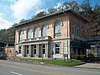 | October 26, 1984 (#84000782) | 305 MacCorkle Ave. 38°20′47″N 81°38′18″W / 38.346389°N 81.638333°W / 38.346389; -81.638333 (Chesapeake and Ohio Depot) | Charleston | |
16 | Chilton House |  | April 29, 1977 (#77001376) | Off U.S. Route 60 38°23′13″N 81°50′24″W / 38.386944°N 81.84°W / 38.386944; -81.84 (Chilton House) | St. Albans | |
17 | W.E. Chilton II House |  | October 26, 1984 (#84000397) | 1266 Louden Heights Rd. 38°19′57″N 81°38′40″W / 38.3325°N 81.644444°W / 38.3325; -81.644444 (W.E. Chilton II House) | Charleston | |
18 | Clendenin Historic District | 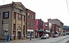 | May 2, 1996 (#96000442) | Roughly bounded by First Ave. and Kanawha Ave. between 5th St. and French St. 38°29′22″N 81°20′51″W / 38.489444°N 81.3475°W / 38.489444; -81.3475 (Clendenin Historic District) | Clendenin | |
19 | Coal River Locks, Dams, and Log Booms Archeological District | November 24, 1997 (#97001417) | Address Restricted | Alum Creek | ||
20 | Cox-Morton House |  | October 26, 1984 (#84000399) | 640 Holley Rd. 38°20′51″N 81°38′41″W / 38.3475°N 81.644722°W / 38.3475; -81.644722 (Cox-Morton House) | Charleston | |
21 | Cox-Parks House |  | October 26, 1984 (#84000400) | 710 Myrtle Rd. 38°20′47″N 81°38′43″W / 38.346389°N 81.645278°W / 38.346389; -81.645278 (Cox-Parks House) | Charleston | |
22 | Craik-Patton House |  | August 12, 1970 (#75001894) | U.S. Route 60 in Daniel Boone Roadside Park 38°19′54″N 81°35′10″W / 38.331667°N 81.586111°W / 38.331667; -81.586111 (Craik-Patton House) | Charleston | |
23 | Crawford-Gardner House |  | October 26, 1984 (#84000401) | 743 Myrtle Rd. 38°20′43″N 81°38′34″W / 38.345278°N 81.642778°W / 38.345278; -81.642778 (Crawford-Gardner House) | Charleston | |
24 | Dalgain |  | October 26, 1984 (#84000404) | 1223 Staunton Rd. 38°20′18″N 81°38′15″W / 38.338333°N 81.6375°W / 38.338333; -81.6375 (Dalgain) | Charleston | |
25 | Danner-Fletcher House |  | October 26, 1984 (#84000405) | 626 Holley Rd. 38°20′52″N 81°38′46″W / 38.347778°N 81.646111°W / 38.347778; -81.646111 (Danner-Fletcher House) | Charleston | |
26 | Downtown Charleston Historic District |  | March 24, 2006 (#06000166) | Roughly bounded by Washington St. E, Leon Sullivan Way, Kanawha Blvd., and Summers St. 38°21′02″N 81°38′03″W / 38.350556°N 81.634167°W / 38.350556; -81.634167 (Downtown Charleston Historic District) | Charleston | |
27 | Dutch Hollow Wine Cellars |  | December 18, 1970 (#70000654) | Dutch Hollow Rd. 38°22′20″N 81°44′24″W / 38.372222°N 81.74°W / 38.372222; -81.74 (Dutch Hollow Wine Cellars) | Dunbar | |
28 | East End Historic District |  | April 20, 1978 (#78002800) | Roughly bounded by the Kanawha River, Bradford, Quarrier, and Greenbrier Sts.; also roughly bounded by Dixie, Greenbrier, and Lee Sts., and East and Shelton Alleys 38°20′16″N 81°36′53″W / 38.337778°N 81.614722°W / 38.337778; -81.614722 (East End Historic District) | Charleston | Second set of addresses represent a boundary increase of December 16, 2014 |
29 | East Hall |  | September 26, 1988 (#88001585) | West Quadrangle, West Virginia State University 38°22′44″N 81°46′07″W / 38.378889°N 81.768611°W / 38.378889; -81.768611 (East Hall) | Institute | |
30 | Ebenezer Chapel |  | December 16, 1974 (#74002011) | Ohio Ave. S. at Hillview Dr. 38°14′30″N 81°33′59″W / 38.241667°N 81.566389°W / 38.241667; -81.566389 (Ebenezer Chapel) | Marmet | |
31 | Edgewood Historic District | 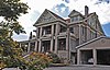 | November 9, 1989 (#89001800) | Roughly bounded by Edgewood Dr., Highland, Beech, Chester, and Lower Chester 38°22′03″N 81°38′42″W / 38.3675°N 81.645°W / 38.3675; -81.645 (Edgewood Historic District) | Charleston | |
32 | William H. & William S. Edwards House | May 11, 1990 (#90000713) | WV 61 northeast of Cabin Creek 38°12′13″N 81°27′56″W / 38.203611°N 81.465556°W / 38.203611; -81.465556 (William H. & William S. Edwards House) | Coalburg | ||
33 | Fort Scammon | 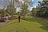 | March 26, 1976 (#76001939) | Atop Fort Hill[5] 38°21′07″N 81°39′18″W / 38.351944°N 81.655000°W / 38.351944; -81.655000 (Fort Scammon) | Charleston | |
34 | Garnet High School |  | July 24, 1990 (#90001068) | 422 Dickinson St. 38°21′04″N 81°37′48″W / 38.351111°N 81.63°W / 38.351111; -81.63 (Garnet High School) | Charleston | |
35 | William S. Gilliland Log Cabin and Cemetery |  | October 26, 1984 (#84000407) | Louden Heights and Bridge Rd. 38°19′47″N 81°38′48″W / 38.329722°N 81.646667°W / 38.329722; -81.646667 (William S. Gilliland Log Cabin and Cemetery) | Charleston | Demolished in 2016 "Deteriorated 1840s WV log cabins coming down" |
36 | Elizabeth Harden Gilmore House | 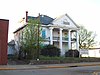 | September 17, 1988 (#88001462) | 514 Broad St. (now Leon Sullivan Way) 38°21′03″N 81°37′39″W / 38.350833°N 81.6275°W / 38.350833; -81.6275 (Elizabeth Harden Gilmore House) | Charleston | |
37 | Good Shepherd Church |  | April 26, 1990 (#90000712) | WV 61 southwest of East Bank 38°12′37″N 81°27′22″W / 38.210278°N 81.456111°W / 38.210278; -81.456111 (Good Shepherd Church) | Coalburg | |
38 | Grosscup Road Historic District |  | January 26, 1984 (#84003607) | Grosscup, Roscommon, Roller, and Bridge Rds. 38°20′35″N 81°38′15″W / 38.343056°N 81.6375°W / 38.343056; -81.6375 (Grosscup Road Historic District) | Charleston | |
39 | Felix G. Hansford House | January 12, 1984 (#84003611) | Centre and 14th Sts. 38°12′20″N 81°23′39″W / 38.205556°N 81.394167°W / 38.205556; -81.394167 (Felix G. Hansford House) | Hansford | ||
40 | John Harriman House | December 15, 1978 (#78002803) | 2233 3rd Ave. 38°12′59″N 81°26′27″W / 38.216389°N 81.440833°W / 38.216389; -81.440833 (John Harriman House) | East Bank | ||
41 | Holly Grove Mansion |  | August 28, 1974 (#74002007) | 1710 E. Kanawha Blvd. 38°20′10″N 81°36′54″W / 38.336111°N 81.615°W / 38.336111; -81.615 (Holly Grove Mansion) | Charleston | |
42 | Kanawha County Courthouse | 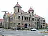 | September 6, 1978 (#78002801) | Virginia and Court Sts. 38°21′03″N 81°38′22″W / 38.350833°N 81.639444°W / 38.350833; -81.639444 (Kanawha County Courthouse) | Charleston | |
43 | Kanawha State Forest Historic District | March 25, 1993 (#93000228) | County Route 42/43 2.6 miles (4.2 km) south of Charleston 38°15′56″N 81°43′37″W / 38.265556°N 81.726944°W / 38.265556; -81.726944 (Kanawha State Forest Historic District) | Loudendale | ||
44 | Kearse Theater | 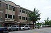 | November 28, 1980 (#80004026) | 161, 165, and 167 Summers St. 38°21′04″N 81°38′07″W / 38.351111°N 81.635278°W / 38.351111; -81.635278 (Kearse Theater) | Charleston | Demolished in 1982. |
45 | Laidley-Summers-Quarrier House |  | December 13, 1978 (#78002802) | 800 Orchard St. 38°22′06″N 81°39′02″W / 38.368333°N 81.650556°W / 38.368333; -81.650556 (Laidley-Summers-Quarrier House) | Charleston | |
46 | Mattie V. Lee Home | 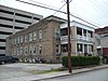 | June 16, 1992 (#92000303) | 810 Donnally St. 38°21′06″N 81°37′51″W / 38.351667°N 81.630833°W / 38.351667; -81.630833 (Mattie V. Lee Home) | Charleston | |
47 | Little Brick Church | 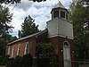 | December 16, 1974 (#74002006) | 0.75 miles (1.21 km) east of Kelley's Creek on U.S. Route 60 38°13′03″N 81°25′34″W / 38.2175°N 81.426111°W / 38.2175; -81.426111 (Little Brick Church) | Cedar Grove | |
48 | Littlepage Stone Mansion |  | September 2, 1982 (#82004325) | 1809 W. Washington St. 38°22′34″N 81°39′58″W / 38.376111°N 81.666111°W / 38.376111; -81.666111 (Littlepage Stone Mansion) | Charleston | |
49 | Loewenstein and Sons Hardware Building |  | November 1, 1985 (#85003475) | 223-225 Capitol St. 38°21′02″N 81°38′05″W / 38.350556°N 81.634722°W / 38.350556; -81.634722 (Loewenstein and Sons Hardware Building) | Charleston | |
50 | Luna Park Historic District |  | April 3, 2012 (#12000181) | Roughly bounded by Main St., Glenwood Ave., Delaware Ave., & Kanawha Blvd. W. 38°21′41″N 81°39′11″W / 38.361496°N 81.653042°W / 38.361496; -81.653042 (Luna Park Historic District) | Charleston | |
51 | MacFarland House |  | December 10, 1979 (#79002585) | 1310 Kanawha Boulevard 38°20′35″N 81°37′49″W / 38.343056°N 81.630278°W / 38.343056; -81.630278 (MacFarland House) | Charleston | |
52 | Malden Historic District | 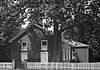 | July 18, 1980 (#80004028) | Roughly bounded by railroad tracks, the Kanawha River, Georges Dr., and U.S. Route 60 38°17′49″N 81°33′35″W / 38.296944°N 81.559722°W / 38.296944; -81.559722 (Malden Historic District) | Malden | |
53 | Maple Terrace Court and Walton Apartments | 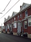 | August 22, 2002 (#02000885) | Maple Terrace Court 38°20′42″N 81°37′39″W / 38.345°N 81.6275°W / 38.345; -81.6275 (Maple Terrace Court and Walton Apartments) | Charleston | |
54 | McAndrews-Gallaher House | 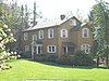 | October 26, 1984 (#84000409) | 601 Briarwood Rd. 38°20′46″N 81°38′52″W / 38.346111°N 81.647778°W / 38.346111; -81.647778 (McAndrews-Gallaher House) | Charleston | |
55 | William E. Mohler House |  | February 10, 1983 (#83003242) | 819 Pennsylvania Ave. 38°23′07″N 81°50′12″W / 38.385278°N 81.836667°W / 38.385278; -81.836667 (William E. Mohler House) | St. Albans | |
56 | Plaza Theatre | 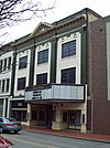 | October 30, 1985 (#85003408) | 123 Summers St. 38°21′00″N 81°38′08″W / 38.35°N 81.635556°W / 38.35; -81.635556 (Plaza Theatre) | Charleston | |
57 | Pratt Historic District | January 12, 1984 (#84003615) | Roughly bounded by Ferry St., the Kanawha River, and Charles and Pratt Aves., including the cemetery 38°12′32″N 81°22′52″W / 38.208889°N 81.381111°W / 38.208889; -81.381111 (Pratt Historic District) | Pratt | ||
58 | St. Albans Chesapeake and Ohio Railroad Depot |  | July 9, 1997 (#97000785) | 410 4th Ave. 38°23′16″N 81°49′57″W / 38.387778°N 81.8325°W / 38.387778; -81.8325 (St. Albans Chesapeake and Ohio Railroad Depot) | St. Albans | |
59 | St. Albans Main Street Historic District |  | November 2, 2000 (#00001315) | Roughly bounded by Main St. between Second St. and B St. 38°23′11″N 81°50′13″W / 38.386389°N 81.836944°W / 38.386389; -81.836944 (St. Albans Main Street Historic District) | St. Albans | |
60 | St. Albans Post Office |  | November 4, 1994 (#94001285) | 202 Sixth Ave. 38°23′11″N 81°50′09″W / 38.386389°N 81.835833°W / 38.386389; -81.835833 (St. Albans Post Office) | St. Albans | |
61 | St. Albans Site |  | May 3, 1974 (#74002012) | U.S. Route 60 along the Kanawha River[6] 38°23′09″N 81°48′29″W / 38.385833°N 81.808056°W / 38.385833; -81.808056 (St. Albans Site) | St. Albans | |
62 | St. John's Episcopal Church | 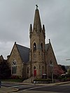 | November 2, 1989 (#89001782) | 11105 Quarrier St. 38°20′49″N 81°37′56″W / 38.346944°N 81.632222°W / 38.346944; -81.632222 (St. John's Episcopal Church) | Charleston | |
63 | St. Mark's Episcopal Church |  | November 7, 1977 (#77001377) | 405-407 B St. 38°23′18″N 81°50′19″W / 38.388333°N 81.838611°W / 38.388333; -81.838611 (St. Mark's Episcopal Church) | St. Albans | |
64 | St. Paul Baptist Church | 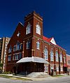 | April 13, 1998 (#98000285) | 821 B St. 38°23′04″N 81°50′20″W / 38.384444°N 81.838889°W / 38.384444; -81.838889 (St. Paul Baptist Church) | St. Albans | |
65 | Samuel Shrewsbury, Sr. House |  | November 2, 1978 (#78002799) | 310 Stubb Dr. 38°14′15″N 81°32′39″W / 38.2375°N 81.544167°W / 38.2375; -81.544167 (Samuel Shrewsbury, Sr. House) | Belle | |
66 | Simpson Memorial Methodist Episcopal Church |  | August 5, 1991 (#91001011) | 607 Shrewsbury St. 38°21′06″N 81°37′44″W / 38.351667°N 81.628889°W / 38.351667; -81.628889 (Simpson Memorial Methodist Episcopal Church) | Charleston | |
67 | Smith-Giltinan House |  | March 20, 2002 (#02000253) | 1223 Virginia St., E. 38°20′39″N 81°37′51″W / 38.344167°N 81.630833°W / 38.344167; -81.630833 (Smith-Giltinan House) | Charleston | |
68 | South Charleston Mound |  | October 15, 1970 (#70000655) | U.S. Route 60, in city park 38°22′07″N 81°41′48″W / 38.368611°N 81.696667°W / 38.368611; -81.696667 (South Charleston Mound) | South Charleston | |
69 | Spring Hill Cemetery Historic District |  | October 18, 1985 (#85003360) | 1554 Farnsworth Dr. 38°21′11″N 81°36′57″W / 38.353056°N 81.615833°W / 38.353056; -81.615833 (Spring Hill Cemetery Historic District) | Charleston | |
70 | Samuel Starks House | 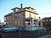 | February 1, 1988 (#87002526) | 413 Shrewsbury St. 38°21′02″N 81°37′50″W / 38.350556°N 81.630556°W / 38.350556; -81.630556 (Samuel Starks House) | Charleston | |
71 | Sterrett Brothers' Dry Goods Store | 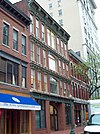 | November 29, 2001 (#01001329) | 112 Capitol St. 38°20′58″N 81°38′08″W / 38.349444°N 81.635556°W / 38.349444; -81.635556 (Sterrett Brothers' Dry Goods Store) | Charleston | |
72 | Stoneleigh |  | October 26, 1984 (#84000411) | 909 Ridgeway Rd. 38°20′17″N 81°38′19″W / 38.338056°N 81.638611°W / 38.338056; -81.638611 (Stoneleigh) | Charleston | |
73 | Summers House | 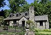 | November 24, 2015 (#15000841) | 805 Loudon Heights Rd. 38°20′25″N 81°38′14″W / 38.340335°N 81.637170°W / 38.340335; -81.637170 (Summers House) | Charleston | |
74 | Sunrise |  | July 24, 1974 (#74002008) | 746 Myrtle Rd. 38°20′44″N 81°38′29″W / 38.345556°N 81.641389°W / 38.345556; -81.641389 (Sunrise) | Charleston | |
75 | Thomas-McJunkin-Love House |  | October 26, 1984 (#84000413) | 920 Newton Rd. 38°20′26″N 81°38′23″W / 38.340556°N 81.639722°W / 38.340556; -81.639722 (Thomas-McJunkin-Love House) | Charleston | |
76 | United Carbon Building | 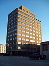 | July 15, 1994 (#94000720) | 1018 Kanawha Blvd., E. 38°20′46″N 81°38′04″W / 38.346111°N 81.634444°W / 38.346111; -81.634444 (United Carbon Building) | Charleston | |
77 | Booker T. Washington High School | December 3, 1999 (#99001399) | Wyatt St. off U.S. Route 60 38°12′04″N 81°22′17″W / 38.201111°N 81.371389°W / 38.201111; -81.371389 (Booker T. Washington High School) | London | ||
78 | James Weimer House | 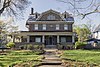 | April 14, 2004 (#04000309) | 411 8th Ave. 38°23′03″N 81°50′03″W / 38.384167°N 81.834167°W / 38.384167; -81.834167 (James Weimer House) | St. Albans | |
79 | West Virginia Capitol Complex |  | December 31, 1974 (#74002009) | Along Kanawha Boulevard, E. 38°20′11″N 81°36′44″W / 38.336389°N 81.612222°W / 38.336389; -81.612222 (West Virginia Capitol Complex) | Charleston | The West Virginia Capitol Complex consists of two primary sites, the West Virginia State Capitol and West Virginia Governor's Mansion.[7] |
80 | Col. Henry Hewitt Wood House |  | November 28, 1980 (#80004027) | 6560 Roosevelt Ave., SE. 38°18′00″N 81°33′46″W / 38.3°N 81.562778°W / 38.3; -81.562778 (Col. Henry Hewitt Wood House) | Charleston | |
81 | Woodrums' Building | 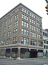 | April 18, 1996 (#96000439) | 602 E. Virginia St. 38°21′01″N 81°38′15″W / 38.350278°N 81.6375°W / 38.350278; -81.6375 (Woodrums' Building) | Charleston | |
82 | Young-Noyes House | 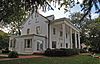 | April 25, 1991 (#91000446) | 2122 Kanawha Ave. 38°20′02″N 81°37′05″W / 38.333889°N 81.618056°W / 38.333889; -81.618056 (Young-Noyes House) | Charleston |
Former listing[edit]
| [3] | Name on the Register | Image | Date listed | Date removed | Location | City or town | Summary |
|---|---|---|---|---|---|---|---|
1 | Mother Jones Prison | April 27, 1992 (#92001876) | September 22, 1997 | 305 Center Street 38°12′38″N 81°23′01″W / 38.2106°N 81.3837°W / 38.2106; -81.3837 (Mother Jones Prison) | Pratt | Added on April 27, 1992 as National Historic Landmark, delisted in 1997 after demolition in 1996. Included in Pratt Historic District. |
See also[edit]
| Wikimedia Commons has media related to National Register of Historic Places in Kanawha County, West Virginia. |
- List of National Historic Landmarks in West Virginia
- National Register of Historic Places listings in West Virginia
References[edit]
^ The latitude and longitude information provided in this table was derived originally from the National Register Information System, which has been found to be fairly accurate for about 99% of listings. For about 1% of NRIS original coordinates, experience has shown that one or both coordinates are typos or otherwise extremely far off; some corrections may have been made. A more subtle problem causes many locations to be off by up to 150 yards, depending on location in the country: most NRIS coordinates were derived from tracing out latitude and longitudes from USGS topographical quadrant maps created under the North American Datum of 1927, which differs from the current, highly accurate WGS84 GPS system used by most on-line maps. Chicago is about right, but NRIS longitudes in Washington are higher by about 4.5 seconds, and are lower by about 2.0 seconds in Maine. Latitudes differ by about 1.0 second in Florida. Some locations in this table may have been corrected to current GPS standards.
^ "National Register of Historic Places: Weekly List Actions". National Park Service, United States Department of the Interior. Retrieved on November 16, 2018.
^ ab Numbers represent an ordering by significant words. Various colorings, defined here, differentiate National Historic Landmarks and historic districts from other NRHP buildings, structures, sites or objects.
^ The eight-digit number below each date is the number assigned to each location in the National Register Information System database, which can be viewed by clicking the number.
^ Cook, Roy Bird. "The Civil War Comes to Charleston", West Virginia History 23.2 (1962): 153-167.
^ Broyles, Bettye J., and James E. Harding. National Register of Historic Places Inventory/Nomination: St. Albans Site. National Park Service, 1974-02-07, 2.
^ "National Register of Historic Places Inventory Nomination Form" (PDF). West Virginia Capitol Complex. State of West Virginia, West Virginia Division of Culture and History, Historic Preservation. 2009-04-04..mw-parser-output cite.citation{font-style:inherit}.mw-parser-output q{quotes:"""""""'""'"}.mw-parser-output code.cs1-code{color:inherit;background:inherit;border:inherit;padding:inherit}.mw-parser-output .cs1-lock-free a{background:url("//upload.wikimedia.org/wikipedia/commons/thumb/6/65/Lock-green.svg/9px-Lock-green.svg.png")no-repeat;background-position:right .1em center}.mw-parser-output .cs1-lock-limited a,.mw-parser-output .cs1-lock-registration a{background:url("//upload.wikimedia.org/wikipedia/commons/thumb/d/d6/Lock-gray-alt-2.svg/9px-Lock-gray-alt-2.svg.png")no-repeat;background-position:right .1em center}.mw-parser-output .cs1-lock-subscription a{background:url("//upload.wikimedia.org/wikipedia/commons/thumb/a/aa/Lock-red-alt-2.svg/9px-Lock-red-alt-2.svg.png")no-repeat;background-position:right .1em center}.mw-parser-output .cs1-subscription,.mw-parser-output .cs1-registration{color:#555}.mw-parser-output .cs1-subscription span,.mw-parser-output .cs1-registration span{border-bottom:1px dotted;cursor:help}.mw-parser-output .cs1-hidden-error{display:none;font-size:100%}.mw-parser-output .cs1-visible-error{font-size:100%}.mw-parser-output .cs1-subscription,.mw-parser-output .cs1-registration,.mw-parser-output .cs1-format{font-size:95%}.mw-parser-output .cs1-kern-left,.mw-parser-output .cs1-kern-wl-left{padding-left:0.2em}.mw-parser-output .cs1-kern-right,.mw-parser-output .cs1-kern-wl-right{padding-right:0.2em}
U.S. National Register of Historic Places in West Virginia | ||
|---|---|---|
| Topics |
|  |
| Lists by county |
| |
| Other lists |
| |
| ||
Municipalities and communities of Kanawha County, West Virginia, United States | ||
|---|---|---|
County seat: Charleston | ||
| Cities |
|  |
| Towns |
| |
| CDPs |
| |
| Unincorporated communities |
| |
| Ghost towns |
| |
| Footnotes | ‡This populated place also has portions in an adjacent county or counties | |
Categories:
- National Register of Historic Places in Kanawha County, West Virginia
- Lists of National Register of Historic Places in West Virginia by county
(window.RLQ=window.RLQ||).push(function(){mw.config.set({"wgPageParseReport":{"limitreport":{"cputime":"1.356","walltime":"1.628","ppvisitednodes":{"value":32426,"limit":1000000},"ppgeneratednodes":{"value":0,"limit":1500000},"postexpandincludesize":{"value":532592,"limit":2097152},"templateargumentsize":{"value":48553,"limit":2097152},"expansiondepth":{"value":10,"limit":40},"expensivefunctioncount":{"value":0,"limit":500},"unstrip-depth":{"value":1,"limit":20},"unstrip-size":{"value":7376,"limit":5000000},"entityaccesscount":{"value":1,"limit":400},"timingprofile":["100.00% 1009.411 1 -total"," 69.07% 697.205 83 Template:NRHP_row"," 16.18% 163.364 172 Template:First_word"," 13.13% 132.565 82 Template:Coord"," 12.71% 128.330 84 Template:Designation/color"," 12.11% 122.210 85 Template:Dts"," 11.62% 117.324 83 Template:NRHP_color"," 10.10% 101.951 1 Template:Reflist"," 9.36% 94.452 82 Template:NRHP_Focus"," 8.52% 86.033 1 Template:Commons_category"]},"scribunto":{"limitreport-timeusage":{"value":"0.442","limit":"10.000"},"limitreport-memusage":{"value":4701269,"limit":52428800}},"cachereport":{"origin":"mw1328","timestamp":"20181122004810","ttl":1900800,"transientcontent":false}}});});{"@context":"https://schema.org","@type":"Article","name":"National Register of Historic Places listings in Kanawha County, West Virginia","url":"https://en.wikipedia.org/wiki/National_Register_of_Historic_Places_listings_in_Kanawha_County,_West_Virginia","sameAs":"http://www.wikidata.org/entity/Q6976475","mainEntity":"http://www.wikidata.org/entity/Q6976475","author":{"@type":"Organization","name":"Contributors to Wikimedia projects"},"publisher":{"@type":"Organization","name":"Wikimedia Foundation, Inc.","logo":{"@type":"ImageObject","url":"https://www.wikimedia.org/static/images/wmf-hor-googpub.png"}},"datePublished":"2009-01-09T13:48:23Z","dateModified":"2018-10-02T00:53:44Z","image":"https://upload.wikimedia.org/wikipedia/commons/6/6f/Map_of_West_Virginia_highlighting_Kanawha_County.svg","headline":"Wikimedia list article"}(window.RLQ=window.RLQ||).push(function(){mw.config.set({"wgBackendResponseTime":1739,"wgHostname":"mw1328"});});


