1912 United States presidential election in California
1912 United States presidential election in California
Jump to navigation
Jump to search
| |||||||||||||||||||||||||||||||||
| |||||||||||||||||||||||||||||||||
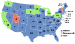
 County Results Wilson—60-70% Wilson—50-60% Wilson—40-50% Roosevelt—40-50% Roosevelt—50-60% | |||||||||||||||||||||||||||||||||
| |||||||||||||||||||||||||||||||||


The 1912 United States presidential election in California refers to how California participated in the 1912 United States presidential election. California narrowly voted for the Progressive nominee, former Republican president Theodore Roosevelt, over the Democratic nominee, New Jersey Governor Woodrow Wilson, though two electors cast their votes for Wilson. The incumbent, Republican William Howard Taft, did not appear on the ballot and was a write-in candidate.[a]
This was the closest presidential election in California history, with Roosevelt winning by just 174 votes out of 677,944 cast, a margin of 0.02567 percent. It remains the fourth-closest presidential race in any state in history, with the only closer one since being the controversial Florida election of 2000, and the only others being two in Maryland in 1832 and 1904, the latter of which also involved Roosevelt.[b]
Although Wilson narrowly failed to win the state, he did become the first Democrat to carry Napa, Solano[c] and Marin Counties since James Buchanan in 1856, the first to carry Sacramento County and Sierra County since Stephen A. Douglas in 1860, the first to win San Diego County since 1868, the first to ever carry Ventura County, which had been created in 1872, and the first to carry Sutter County since 1876.[1] Since this election, Solano County has voted Democratic in all but six Republican landslide elections of 1920, 1924, 1928, 1972, 1980 and 1984.
With 41.83% of the popular vote, California would prove to be Roosevelt's second strongest state in terms of popular vote percentage in the 1912 election after South Dakota.[2]
Contents
1 Results
2 Results by county
3 References
4 Notes
Results[edit]
| United States presidential election in California, 1912[3] | |||||
|---|---|---|---|---|---|
| Party | Candidate | Votes | Percentage | Electoral votes | |
Progressive | Theodore Roosevelt | 283,610 | 41.83% | 11 | |
Democratic | Woodrow Wilson | 283,436 | 41.81% | 2 | |
Socialist | Eugene V. Debs | 79,201 | 11.68% | 0 | |
Prohibition | Eugene W. Chafin | 23,366 | 3.45% | 0 | |
No party | Write-ins | 4,417 | 0.65% | 0 | |
No party | William Howard Taft (inc.) (write-in) | 3,914 | 0.58% | 0 | |
| Invalid or blank votes | — | ||||
Totals | 677,944 | 100.00% | 13 | ||
| Voter turnout | — | ||||
Results by county[edit]
| County | Roosevelt | Votes | Wilson | Votes | Debs | Votes | Chafin | Votes | Others | Votes |
|---|---|---|---|---|---|---|---|---|---|---|
Riverside | 50.94% | 5,146 | 29.33% | 2,963 | 10.25% | 1,036 | 8.25% | 834 | 1.23% | 124 |
Alameda | 47.47% | 31,542 | 36.75% | 24,418 | 14.04% | 9,332 | 1.75% | 1,160 | 0.00% | 0 |
Santa Clara | 46.97% | 10,868 | 39.64% | 9,173 | 8.94% | 2,068 | 3.56% | 824 | 0.89% | 206 |
Santa Barbara | 46.78% | 3,395 | 38.84% | 2,819 | 8.53% | 619 | 4.92% | 357 | 0.94% | 68 |
Los Angeles | 45.73% | 75,593 | 33.34% | 55,110 | 12.04% | 19,895 | 4.95% | 8,190 | 3.94% | 6,508 |
Orange | 45.03% | 5,143 | 38.58% | 4,406 | 7.85% | 896 | 7.46% | 852 | 1.09% | 124 |
Alpine | 45.00% | 36 | 42.50% | 34 | 2.50% | 2 | 0.00% | 0 | 10.00% | 8 |
Del Norte | 44.60% | 376 | 38.32% | 323 | 12.34% | 104 | 4.74% | 40 | 0.00% | 0 |
Placer | 43.91% | 1,913 | 41.84% | 1,823 | 11.04% | 481 | 2.87% | 125 | 0.34% | 15 |
Yuba | 43.36% | 1,132 | 47.57% | 1,242 | 7.12% | 186 | 1.30% | 34 | 0.65% | 17 |
Marin | 42.97% | 2,750 | 44.52% | 2,849 | 11.45% | 733 | 1.06% | 68 | 0.00% | 0 |
Plumas | 42.78% | 762 | 41.66% | 742 | 13.25% | 236 | 1.68% | 30 | 0.62% | 11 |
Santa Cruz | 42.77% | 3,059 | 40.20% | 2,875 | 12.47% | 892 | 4.52% | 323 | 0.04% | 3 |
San Luis Obispo | 42.73% | 2,373 | 40.48% | 2,248 | 12.68% | 704 | 3.85% | 214 | 0.25% | 14 |
Fresno | 42.71% | 8,839 | 42.96% | 8,891 | 11.01% | 2,278 | 2.85% | 590 | 0.47% | 98 |
Ventura | 42.52% | 2,055 | 43.62% | 2,108 | 8.81% | 426 | 3.50% | 169 | 1.55% | 75 |
Napa | 42.52% | 2,432 | 46.55% | 2,662 | 8.36% | 478 | 2.20% | 126 | 0.37% | 21 |
Contra Costa | 42.38% | 3,539 | 39.40% | 3,290 | 15.57% | 1,300 | 2.17% | 181 | 0.48% | 40 |
Tulare | 42.21% | 4,283 | 42.31% | 4,293 | 12.15% | 1,233 | 2.61% | 265 | 0.72% | 73 |
Humboldt | 42.20% | 3,609 | 33.76% | 2,887 | 20.83% | 1,781 | 2.07% | 177 | 1.15% | 98 |
Imperial | 42.17% | 1,420 | 38.46% | 1,295 | 13.25% | 446 | 5.73% | 193 | 0.39% | 13 |
Monterey | 42.02% | 3,081 | 46.26% | 3,392 | 7.60% | 557 | 4.11% | 301 | 0.01% | 1 |
Solano | 41.95% | 3,353 | 45.66% | 3,650 | 9.77% | 781 | 2.11% | 169 | 0.50% | 40 |
Sierra | 41.71% | 483 | 44.47% | 515 | 11.49% | 133 | 1.12% | 13 | 1.21% | 14 |
Sutter | 41.11% | 846 | 51.65% | 1,063 | 3.84% | 79 | 3.16% | 65 | 0.24% | 5 |
San Benito | 40.96% | 1,054 | 48.70% | 1,253 | 6.96% | 179 | 2.88% | 74 | 0.51% | 13 |
Sonoma | 40.89% | 5,806 | 45.78% | 6,500 | 10.52% | 1,494 | 2.58% | 367 | 0.23% | 32 |
San Mateo | 40.44% | 2,825 | 46.47% | 3,246 | 11.84% | 827 | 1.15% | 80 | 0.10% | 7 |
San Bernardino | 40.42% | 6,202 | 38.03% | 5,835 | 12.39% | 1,901 | 8.04% | 1,233 | 1.12% | 172 |
Stanislaus | 39.78% | 3,143 | 39.58% | 3,127 | 9.48% | 749 | 10.94% | 864 | 0.22% | 17 |
Mendocino | 39.61% | 2,237 | 44.39% | 2,507 | 13.31% | 752 | 2.50% | 141 | 0.19% | 11 |
Lassen | 39.59% | 559 | 45.61% | 644 | 10.48% | 148 | 2.41% | 34 | 1.91% | 27 |
Sacramento | 39.23% | 7,534 | 51.39% | 9,869 | 8.09% | 1,553 | 1.11% | 213 | 0.19% | 36 |
Madera | 38.98% | 943 | 47.71% | 1,154 | 9.34% | 226 | 3.68% | 89 | 0.29% | 7 |
San Francisco | 38.17% | 38,610 | 48.40% | 48,953 | 12.21% | 12,354 | 1.14% | 1,158 | 0.07% | 73 |
Butte | 38.14% | 3,365 | 45.66% | 4,028 | 10.54% | 930 | 5.54% | 489 | 0.11% | 10 |
Glenn | 37.21% | 906 | 54.41% | 1,325 | 5.17% | 126 | 2.75% | 67 | 0.45% | 11 |
Merced | 37.16% | 1,571 | 46.78% | 1,978 | 10.43% | 441 | 5.39% | 228 | 0.24% | 10 |
San Diego | 36.46% | 7,922 | 44.79% | 9,731 | 13.22% | 2,873 | 5.24% | 1,139 | 0.29% | 63 |
Tehama | 36.01% | 1,218 | 47.16% | 1,595 | 11.47% | 388 | 4.97% | 168 | 0.38% | 13 |
Kings | 35.94% | 1,419 | 49.82% | 1,967 | 10.28% | 406 | 3.95% | 156 | 0.00% | 0 |
Modoc | 35.47% | 608 | 54.90% | 941 | 6.94% | 119 | 2.63% | 45 | 0.06% | 1 |
Siskiyou | 34.99% | 1,740 | 49.57% | 2,465 | 12.73% | 633 | 2.09% | 104 | 0.62% | 31 |
Shasta | 34.93% | 1,636 | 43.55% | 2,040 | 20.03% | 938 | 1.15% | 54 | 0.34% | 16 |
Trinity | 34.44% | 343 | 46.29% | 461 | 18.27% | 182 | 0.90% | 9 | 0.10% | 1 |
Nevada | 34.40% | 1,381 | 46.11% | 1,851 | 16.14% | 648 | 2.77% | 111 | 0.57% | 23 |
Kern | 33.88% | 3,647 | 51.73% | 5,569 | 12.08% | 1,300 | 1.69% | 182 | 0.62% | 67 |
Yolo | 33.35% | 1,332 | 56.06% | 2,239 | 7.54% | 301 | 2.83% | 113 | 0.23% | 9 |
San Joaquin | 31.40% | 4,314 | 58.00% | 7,969 | 7.24% | 995 | 3.10% | 426 | 0.25% | 35 |
Lake | 30.10% | 649 | 51.86% | 1,118 | 12.34% | 266 | 5.71% | 123 | 0.00% | 0 |
Colusa | 29.26% | 810 | 63.58% | 1,760 | 4.01% | 111 | 3.03% | 84 | 0.11% | 3 |
Tuolumne | 28.76% | 755 | 55.58% | 1,459 | 13.83% | 363 | 1.45% | 38 | 0.38% | 10 |
Mono | 28.73% | 106 | 49.32% | 182 | 18.16% | 67 | 2.98% | 11 | 0.81% | 3 |
El Dorado | 28.40% | 776 | 59.04% | 1,613 | 10.18% | 278 | 1.79% | 49 | 0.59% | 16 |
Amador | 27.33% | 684 | 64.80% | 1,622 | 5.39% | 135 | 2.28% | 57 | 0.20% | 5 |
Inyo | 26.49% | 431 | 49.54% | 806 | 18.75% | 305 | 4.73% | 77 | 0.49% | 8 |
Mariposa | 26.15% | 306 | 58.89% | 689 | 11.79% | 138 | 1.45% | 17 | 1.71% | 20 |
Calaveras | 24.28% | 750 | 60.51% | 1869 | 12.92% | 399 | 2.14% | 66 | 0.16% | 5 |
References[edit]
^ Menendez, Albert J.; The Geography of Presidential Elections in the United States, 1868-2004, pp. 153-155 .mw-parser-output cite.citation{font-style:inherit}.mw-parser-output .citation q{quotes:"""""""'""'"}.mw-parser-output .citation .cs1-lock-free a{background:url("//upload.wikimedia.org/wikipedia/commons/thumb/6/65/Lock-green.svg/9px-Lock-green.svg.png")no-repeat;background-position:right .1em center}.mw-parser-output .citation .cs1-lock-limited a,.mw-parser-output .citation .cs1-lock-registration a{background:url("//upload.wikimedia.org/wikipedia/commons/thumb/d/d6/Lock-gray-alt-2.svg/9px-Lock-gray-alt-2.svg.png")no-repeat;background-position:right .1em center}.mw-parser-output .citation .cs1-lock-subscription a{background:url("//upload.wikimedia.org/wikipedia/commons/thumb/a/aa/Lock-red-alt-2.svg/9px-Lock-red-alt-2.svg.png")no-repeat;background-position:right .1em center}.mw-parser-output .cs1-subscription,.mw-parser-output .cs1-registration{color:#555}.mw-parser-output .cs1-subscription span,.mw-parser-output .cs1-registration span{border-bottom:1px dotted;cursor:help}.mw-parser-output .cs1-ws-icon a{background:url("//upload.wikimedia.org/wikipedia/commons/thumb/4/4c/Wikisource-logo.svg/12px-Wikisource-logo.svg.png")no-repeat;background-position:right .1em center}.mw-parser-output code.cs1-code{color:inherit;background:inherit;border:inherit;padding:inherit}.mw-parser-output .cs1-hidden-error{display:none;font-size:100%}.mw-parser-output .cs1-visible-error{font-size:100%}.mw-parser-output .cs1-maint{display:none;color:#33aa33;margin-left:0.3em}.mw-parser-output .cs1-subscription,.mw-parser-output .cs1-registration,.mw-parser-output .cs1-format{font-size:95%}.mw-parser-output .cs1-kern-left,.mw-parser-output .cs1-kern-wl-left{padding-left:0.2em}.mw-parser-output .cs1-kern-right,.mw-parser-output .cs1-kern-wl-right{padding-right:0.2em}
ISBN 0786422173
^ "1912 Presidential Election Statistics". Dave Leip’s Atlas of U.S. Presidential Elections. Retrieved 2018-03-05.
^ "1912 Presidential General Election Results - California". Dave Leip's U.S. Election Atlas. Retrieved 2008-08-25.
Notes[edit]
^ Other incumbent Presidents not on the ballot in all states have been Benjamin Harrison in Florida in 1892, Taft in South Dakota during this 1912 election, Harry S. Truman in Alabama in 1948, and Lyndon Johnson in also in Alabama in 1964.
^ Although Roosevelt won Maryland by fifty-one votes, voters in Maryland in those days voted for individual electors and only one Republican, elector, Charles Bonaparte, survived the tally. The other seven top vote recipients were Democrats.
^ "Southern Democrat" John Breckinridge (Buchanan's Vice-President) did carry Solano County in 1860
State results of the 1912 U.S. presidential election | ||
|---|---|---|
| Candidates |
|  |
| General articles |
| |
| Local results |
| |
| Other 1912 elections |
| |
Categories:
- 1912 United States presidential election by state
- United States presidential elections in California
- 1912 California elections
(window.RLQ=window.RLQ||).push(function(){mw.config.set({"wgPageParseReport":{"limitreport":{"cputime":"0.576","walltime":"0.697","ppvisitednodes":{"value":4822,"limit":1000000},"ppgeneratednodes":{"value":0,"limit":1500000},"postexpandincludesize":{"value":185677,"limit":2097152},"templateargumentsize":{"value":11182,"limit":2097152},"expansiondepth":{"value":15,"limit":40},"expensivefunctioncount":{"value":8,"limit":500},"unstrip-depth":{"value":1,"limit":20},"unstrip-size":{"value":9794,"limit":5000000},"entityaccesscount":{"value":0,"limit":400},"timingprofile":["100.00% 398.354 1 -total"," 50.03% 199.313 1 Template:Infobox_Election"," 40.43% 161.049 1 Template:Infobox"," 29.85% 118.894 2 Template:Reflist"," 20.90% 83.273 3 Template:Infobox_election/row"," 13.74% 54.718 1 Template:ISBN"," 11.71% 46.650 2 Template:Cite_web"," 8.86% 35.313 1 Template:Catalog_lookup_link"," 7.63% 30.400 3 Template:Navbox"," 6.96% 27.732 1 Template:California_U.S._Presidential_elections"]},"scribunto":{"limitreport-timeusage":{"value":"0.089","limit":"10.000"},"limitreport-memusage":{"value":3553379,"limit":52428800}},"cachereport":{"origin":"mw1254","timestamp":"20190203051604","ttl":2073600,"transientcontent":false}}});mw.config.set({"wgBackendResponseTime":104,"wgHostname":"mw1324"});});


