Shire of Yilgarn
Shire of Yilgarn
Jump to navigation
Jump to search
Shire of Yilgarn Western Australia | |||||||||||||||
|---|---|---|---|---|---|---|---|---|---|---|---|---|---|---|---|
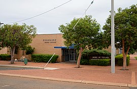 Yilgarn Shire Office, Southern Cross, 2017 | |||||||||||||||
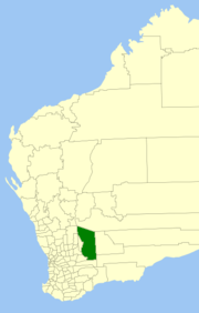 Location in Western Australia | |||||||||||||||
| Population | 1,698 (2013 est)[1] | ||||||||||||||
| • Density | 0.055273/km2 (0.14316/sq mi) | ||||||||||||||
| Established | 1891 | ||||||||||||||
| Area | 30,720 km2 (11,861.1 sq mi) | ||||||||||||||
| Mayor | Onida Truran | ||||||||||||||
| Council seat | Southern Cross | ||||||||||||||
| Region | Eastern Wheatbelt | ||||||||||||||
| State electorate(s) | Eyre | ||||||||||||||
| Federal Division(s) | Kalgoorlie | ||||||||||||||
| Website | Shire of Yilgarn | ||||||||||||||
| |||||||||||||||
The Shire of Yilgarn is a local government area in the Eastern Wheatbelt region of Western Australia about 400 kilometres (250 mi) east of Perth, the state capital. The Shire covers an area of 30,720 square kilometres (11,860 sq mi) and its seat of government is the town of Southern Cross. The main industries within the Shire are mining and farming.
Contents
1 History
2 Wards
3 Towns and localities
4 Notable councillors
5 References
6 External links
History[edit]
In 1891, the Yilgarn Road District was gazetted. In 1918, it merged with the Municipality of Southern Cross (gazetted 1892). On 1 July 1961, it became a shire under the Local Government Act 1960.[2]
Wards[edit]
The Shire of Yilgarn has no wards.
The Shire of Yilgarn has 7 councillor.
Towns and localities[edit]
Many of the following are ghost towns associated with short-lived mineral booms between the 1890s and the 1940s.
- Southern Cross
- Baladjie
- Bodallin
- Bullfinch
Colreavy (also known as Golden Valley)- Corinthia
- Dulyalbin
- Ennuin
- Garratt
- Ghooli
- Holleton
- Koolyanobbing
- Marvel Loch
- Moorine Rock
- Mount Hampton
- Mount Holland
- Mount Jackson
- Mount Palmer
- Noongar
- Yellowdine
- Yerbillon
Notable councillors[edit]
William Oats, Southern Cross Municipality mayor 1895–1896; later a state MP
Harold Seddon, Southern Cross Municipality councillor late 1910s; later a state MP
Lionel Kelly, Yilgarn Road Board member 1929–1932, 1932–1943; later a state MP
John Panizza, Shire of Yilgarn councillor 1975–1987, president 1982–1987; later a senator
References[edit]
^ "3218.0 Regional Population Growth, Australia. Table 5. Estimated Resident Population, Local Government Areas, Western Australia". 3 April 2014. Retrieved 11 September 2014..mw-parser-output cite.citation{font-style:inherit}.mw-parser-output q{quotes:"""""""'""'"}.mw-parser-output code.cs1-code{color:inherit;background:inherit;border:inherit;padding:inherit}.mw-parser-output .cs1-lock-free a{background:url("//upload.wikimedia.org/wikipedia/commons/thumb/6/65/Lock-green.svg/9px-Lock-green.svg.png")no-repeat;background-position:right .1em center}.mw-parser-output .cs1-lock-limited a,.mw-parser-output .cs1-lock-registration a{background:url("//upload.wikimedia.org/wikipedia/commons/thumb/d/d6/Lock-gray-alt-2.svg/9px-Lock-gray-alt-2.svg.png")no-repeat;background-position:right .1em center}.mw-parser-output .cs1-lock-subscription a{background:url("//upload.wikimedia.org/wikipedia/commons/thumb/a/aa/Lock-red-alt-2.svg/9px-Lock-red-alt-2.svg.png")no-repeat;background-position:right .1em center}.mw-parser-output .cs1-subscription,.mw-parser-output .cs1-registration{color:#555}.mw-parser-output .cs1-subscription span,.mw-parser-output .cs1-registration span{border-bottom:1px dotted;cursor:help}.mw-parser-output .cs1-hidden-error{display:none;font-size:100%}.mw-parser-output .cs1-visible-error{font-size:100%}.mw-parser-output .cs1-subscription,.mw-parser-output .cs1-registration,.mw-parser-output .cs1-format{font-size:95%}.mw-parser-output .cs1-kern-left,.mw-parser-output .cs1-kern-wl-left{padding-left:0.2em}.mw-parser-output .cs1-kern-right,.mw-parser-output .cs1-kern-wl-right{padding-right:0.2em}
^ WA Electoral Commission, Municipality Boundary Amendments Register (release 3.0), 31 May 2007.
External links[edit]
Official website
Coordinates: 31°15′14″S 119°20′38″E / 31.254°S 119.344°E / -31.254; 119.344
Categories:
- Populated places established in 1891
- 1891 establishments in Australia
- Shire of Yilgarn
(window.RLQ=window.RLQ||).push(function(){mw.config.set({"wgPageParseReport":{"limitreport":{"cputime":"0.316","walltime":"0.389","ppvisitednodes":{"value":1958,"limit":1000000},"ppgeneratednodes":{"value":0,"limit":1500000},"postexpandincludesize":{"value":79752,"limit":2097152},"templateargumentsize":{"value":6317,"limit":2097152},"expansiondepth":{"value":11,"limit":40},"expensivefunctioncount":{"value":3,"limit":500},"unstrip-depth":{"value":1,"limit":20},"unstrip-size":{"value":3296,"limit":5000000},"entityaccesscount":{"value":1,"limit":400},"timingprofile":["100.00% 304.824 1 -total"," 32.15% 97.997 1 Template:Infobox_Australian_place"," 22.05% 67.220 1 Template:Reflist"," 20.70% 63.090 1 Template:Infobox"," 19.75% 60.193 1 Template:Cite_web"," 13.04% 39.753 1 Template:About"," 11.38% 34.698 2 Template:Convert"," 9.35% 28.503 2 Template:Navbox"," 8.08% 24.621 1 Template:Local_Government_Areas_of_Western_Australia"," 7.67% 23.391 1 Template:Official_website"]},"scribunto":{"limitreport-timeusage":{"value":"0.141","limit":"10.000"},"limitreport-memusage":{"value":4823543,"limit":52428800}},"cachereport":{"origin":"mw1333","timestamp":"20181014031004","ttl":1900800,"transientcontent":false}}});mw.config.set({"wgBackendResponseTime":97,"wgHostname":"mw1320"});});

 Clash Royale CLAN TAG

