Shire of Mount Marshall
Shire of Mount Marshall
Jump to navigation
Jump to search
Shire of Mount Marshall Western Australia | |||||||||||||||
|---|---|---|---|---|---|---|---|---|---|---|---|---|---|---|---|
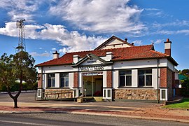 Mount Marshall Shire Hall, Bencubbin, 2018 | |||||||||||||||
 Location in Western Australia | |||||||||||||||
| Population | 527 (2016 census)[1] | ||||||||||||||
| • Density | 0.06/km2 (0.16/sq mi) | ||||||||||||||
| Established | 1923 | ||||||||||||||
| Area | 10,189.5 km2 (3,934.2 sq mi) | ||||||||||||||
| Mayor | Rachel Kirby | ||||||||||||||
| Council seat | Bencubbin | ||||||||||||||
| Region | Wheatbelt | ||||||||||||||
| State electorate(s) | Central Wheatbelt | ||||||||||||||
| Federal Division(s) | Durack | ||||||||||||||
| Website | Shire of Mount Marshall | ||||||||||||||
| |||||||||||||||
The Shire of Mount Marshall is a local government area in the Wheatbelt region of Western Australia, about 80 kilometres (50 mi) north-northwest of Merredin and about 300 kilometres (186 mi) northeast of the state capital, Perth. The Shire covers an area of 10,190 square kilometres (3,934 sq mi), and its seat of government is the town of Bencubbin.
Contents
1 History
2 Wards
3 Towns and localities
4 References
5 External links
History[edit]
The area was first discovered by Surveyor General John Septimus Roe, Mount Marshall and Lake McDermott were named after Captain Marshall McDermont, an early settler to the Swan River Colony. The area was first settled by sandalwood collectors and graziers in 1868. Sandalwood was removed from this area from the 1880s until the 1920s. Permanent settlement and the development and clearing of the land for farms commenced around 1910.
In 1923, the Mount Marshall Road Board was gazetted out of areas formerly managed by Ninghan (Trayning) and Nungarin, and on 1 July 1961, it became a shire following changes to the Local Government Act.[2]
Wards[edit]
The Shire has no wards and each Councillor represents the entire district of the Shire of Mt Marshall as required by the Local Government Act 1995.
Towns and localities[edit]
- Bencubbin
- Beacon
- Cleary
- Gabbin
- Welbungin
- Wialki
References[edit]
^ Australian Bureau of Statistics (27 June 2017). "Mount Marshall (S)". 2016 Census QuickStats. Retrieved 1 December 2017..mw-parser-output cite.citation{font-style:inherit}.mw-parser-output q{quotes:"""""""'""'"}.mw-parser-output code.cs1-code{color:inherit;background:inherit;border:inherit;padding:inherit}.mw-parser-output .cs1-lock-free a{background:url("//upload.wikimedia.org/wikipedia/commons/thumb/6/65/Lock-green.svg/9px-Lock-green.svg.png")no-repeat;background-position:right .1em center}.mw-parser-output .cs1-lock-limited a,.mw-parser-output .cs1-lock-registration a{background:url("//upload.wikimedia.org/wikipedia/commons/thumb/d/d6/Lock-gray-alt-2.svg/9px-Lock-gray-alt-2.svg.png")no-repeat;background-position:right .1em center}.mw-parser-output .cs1-lock-subscription a{background:url("//upload.wikimedia.org/wikipedia/commons/thumb/a/aa/Lock-red-alt-2.svg/9px-Lock-red-alt-2.svg.png")no-repeat;background-position:right .1em center}.mw-parser-output .cs1-subscription,.mw-parser-output .cs1-registration{color:#555}.mw-parser-output .cs1-subscription span,.mw-parser-output .cs1-registration span{border-bottom:1px dotted;cursor:help}.mw-parser-output .cs1-hidden-error{display:none;font-size:100%}.mw-parser-output .cs1-visible-error{font-size:100%}.mw-parser-output .cs1-subscription,.mw-parser-output .cs1-registration,.mw-parser-output .cs1-format{font-size:95%}.mw-parser-output .cs1-kern-left,.mw-parser-output .cs1-kern-wl-left{padding-left:0.2em}.mw-parser-output .cs1-kern-right,.mw-parser-output .cs1-kern-wl-right{padding-right:0.2em}

^ WA Electoral Commission, Municipality Boundary Amendments Register (release 2.0), 31 May 2003.
External links[edit]
Official website
Coordinates: 30°48′40″S 117°51′43″E / 30.811°S 117.862°E / -30.811; 117.862
Categories:
- Populated places established in 1923
- 1923 establishments in Australia
- Local government areas of the Wheatbelt region of Western Australia
(window.RLQ=window.RLQ||).push(function(){mw.config.set({"wgPageParseReport":{"limitreport":{"cputime":"0.300","walltime":"0.384","ppvisitednodes":{"value":1899,"limit":1000000},"ppgeneratednodes":{"value":0,"limit":1500000},"postexpandincludesize":{"value":78077,"limit":2097152},"templateargumentsize":{"value":2810,"limit":2097152},"expansiondepth":{"value":10,"limit":40},"expensivefunctioncount":{"value":4,"limit":500},"unstrip-depth":{"value":1,"limit":20},"unstrip-size":{"value":3599,"limit":5000000},"entityaccesscount":{"value":1,"limit":400},"timingprofile":["100.00% 300.512 1 -total"," 45.65% 137.172 1 Template:Infobox_Australian_place"," 31.13% 93.541 1 Template:Infobox"," 30.81% 92.581 1 Template:Reflist"," 27.99% 84.104 1 Template:Census_2016_AUS"," 19.65% 59.061 1 Template:Cite_web"," 11.48% 34.492 4 Template:Convert"," 10.21% 30.675 2 Template:Navbox"," 8.68% 26.070 1 Template:Local_Government_Areas_of_Western_Australia"," 8.46% 25.430 1 Template:Redirect"]},"scribunto":{"limitreport-timeusage":{"value":"0.138","limit":"10.000"},"limitreport-memusage":{"value":5364273,"limit":52428800}},"cachereport":{"origin":"mw1250","timestamp":"20181013164203","ttl":1900800,"transientcontent":false}}});mw.config.set({"wgBackendResponseTime":83,"wgHostname":"mw1320"});});

 Clash Royale CLAN TAG

