National Register of Historic Places listings in Framingham, Massachusetts
National Register of Historic Places listings in Framingham, Massachusetts
Jump to navigation
Jump to search
Framingham, Massachusetts, has 18 locations listed on the National Register of Historic Places.
This National Park Service list is complete through NPS recent listings posted October 4, 2018.[1]
Current listings[edit]
| [2] | Name on the Register[3] | Image | Date listed[4] | Location | City or town | Description |
|---|---|---|---|---|---|---|
1 | Concord Square Historic District |  | March 10, 1983 (#83000794) | Park, Concord, and Kendall Sts., and Union Ave. 42°16′42″N 71°25′06″W / 42.2783°N 71.4183°W / 42.2783; -71.4183 (Concord Square Historic District) | Framingham | |
2 | Moses Ellis House |  | November 29, 1983 (#83004022) | 283 Pleasant St. 42°18′16″N 71°26′58″W / 42.3044°N 71.4494°W / 42.3044; -71.4494 (Moses Ellis House) | Framingham | |
3 | First Baptist Church |  | April 9, 1980 (#80000642) | 1013 Worcester Rd. 42°18′01″N 71°26′20″W / 42.3003°N 71.4389°W / 42.3003; -71.4389 (First Baptist Church) | Framingham | |
4 | Framingham Centre Common Historic District |  | October 25, 1990 (#90001564) | Roughly centered on Framingham Centre Common, between MA 9 and Interstate 90 42°18′13″N 71°26′08″W / 42.3036°N 71.4356°W / 42.3036; -71.4356 (Framingham Centre Common Historic District) | Framingham | |
5 | Framingham Railroad Station |  | January 17, 1975 (#75000258) | 417 Waverly St. 42°16′35″N 71°25′06″W / 42.2764°N 71.4183°W / 42.2764; -71.4183 (Framingham Railroad Station) | Framingham | |
6 | Framingham Reservoir No. 1 Dam and Gatehouse |  | January 18, 1990 (#89002291) | Eastern end of Framingham Reservoir No. 1, off Winter St. north of Long Ave. 42°17′30″N 71°26′34″W / 42.2917°N 71.4428°W / 42.2917; -71.4428 (Framingham Reservoir No. 1 Dam and Gatehouse) | Framingham | |
7 | Framingham Reservoir No. 2 Dam and Gatehouse |  | January 18, 1990 (#89002290) | Between Framingham Reservoirs Nos. 1 and 2, west of the junction of Winter and Fountain Sts. 42°16′58″N 71°26′45″W / 42.2828°N 71.4458°W / 42.2828; -71.4458 (Framingham Reservoir No. 2 Dam and Gatehouse) | Framingham | |
8 | Framingham Reservoir No. 3 Dam and Gatehouse |  | January 18, 1990 (#89002261) | Southeastern end of Framingham Reservoir No. 3, off MA 9/30 42°17′38″N 71°27′36″W / 42.2939°N 71.46°W / 42.2939; -71.46 (Framingham Reservoir No. 3 Dam and Gatehouse) | Framingham | |
9 | Paul Gibbs House |  | March 10, 1983 (#83000804) | 1147 Edmands Rd. 42°19′49″N 71°28′52″W / 42.3303°N 71.4811°W / 42.3303; -71.4811 (Paul Gibbs House) | Framingham | |
10 | Irving Square Historic District | 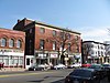 | November 30, 1982 (#82000491) | Irving Square, Waverly, South, Columbia, Irving, Gordon and Hollis Sts. 42°16′32″N 71°25′01″W / 42.2756°N 71.4169°W / 42.2756; -71.4169 (Irving Square Historic District) | Framingham | |
11 | Lake Cochituate Dam | 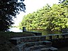 | January 18, 1990 (#89002250) | Northwestern side of Lake Cochituate 42°18′54″N 71°23′05″W / 42.315°N 71.3847°W / 42.315; -71.3847 (Lake Cochituate Dam) | Framingham | |
12 | Saint John's Episcopal Church |  | January 12, 1990 (#89002300) | Maynard Rd. and Church St. 42°17′50″N 71°26′21″W / 42.2972°N 71.4392°W / 42.2972; -71.4392 (Saint John's Episcopal Church) | Framingham | Now the Ecumenical Center at Framingham State University. |
13 | Saxonville Historic District |  | August 20, 1992 (#92000992) | Roughly along Elm, Danforth, Central, Water and Concord Sts. 42°19′29″N 71°24′04″W / 42.3247°N 71.4011°W / 42.3247; -71.4011 (Saxonville Historic District) | Framingham | |
14 | Stone's Bridge |  | January 17, 2017 (#100000527) | Old Stonebridge Rd. across Sudbury River 42°20′21″N 71°23′42″W / 42.339110°N 71.394917°W / 42.339110; -71.394917 (Stone's Bridge) | Wayland | Mainly in Wayland |
15 | Sudbury Aqueduct Linear District |  | January 18, 1990 (#89002293) | Along Sudbury Aqueduct from Farm Pond at Waverly St. (Framingham) to Chestnut Hill Reservoir (Newton) 42°17′33″N 71°18′44″W / 42.2925°N 71.3122°W / 42.2925; -71.3122 (Sudbury Aqueduct Linear District) | Framingham | Extends into Wellesley and Needham in Norfolk County, and Sherborn, Natick and Newton in Middlesex County. |
16 | Sudbury Dam Historic District |  | January 18, 1990 (#89002265) | Southeastern end of Sudbury Reservoir off MA 30 42°18′21″N 71°29′30″W / 42.3058°N 71.4917°W / 42.3058; -71.4917 (Sudbury Dam Historic District) | Framingham | Extends into Southborough, Worcester County. |
17 | Weston Aqueduct Linear District |  | January 18, 1990 (#89002274) | Along the Weston Aqueduct from the Sudbury Reservoir to the Weston Reservoir 42°20′00″N 71°22′32″W / 42.3333°N 71.3756°W / 42.3333; -71.3756 (Weston Aqueduct Linear District) | Framingham | Extends into Southborough, Worcester County, and Weston and Wayland in Middlesex County. |
18 | Whit's Diner | 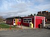 | December 4, 2003 (#03001243) | 184A Fountain St. 42°16′31″N 71°26′02″W / 42.2753°N 71.4339°W / 42.2753; -71.4339 (Whit's Diner) | Framingham |
References[edit]
| Wikimedia Commons has media related to National Register of Historic Places in Framingham, Massachusetts. |
^ https://www.nps.gov/subjects/nationalregister/weekly-list.htm "National Register of Historic Places: Weekly List Actions"]. National Park Service, United States Department of the Interior. Retrieved on October 4, 2018.
^ Numbers represent an ordering by significant words. Various colorings, defined here, differentiate National Historic Landmarks and historic districts from other NRHP buildings, structures, sites or objects.
^ National Park Service (2008-04-24). "National Register Information System". National Register of Historic Places. National Park Service..mw-parser-output cite.citation{font-style:inherit}.mw-parser-output q{quotes:"""""""'""'"}.mw-parser-output code.cs1-code{color:inherit;background:inherit;border:inherit;padding:inherit}.mw-parser-output .cs1-lock-free a{background:url("//upload.wikimedia.org/wikipedia/commons/thumb/6/65/Lock-green.svg/9px-Lock-green.svg.png")no-repeat;background-position:right .1em center}.mw-parser-output .cs1-lock-limited a,.mw-parser-output .cs1-lock-registration a{background:url("//upload.wikimedia.org/wikipedia/commons/thumb/d/d6/Lock-gray-alt-2.svg/9px-Lock-gray-alt-2.svg.png")no-repeat;background-position:right .1em center}.mw-parser-output .cs1-lock-subscription a{background:url("//upload.wikimedia.org/wikipedia/commons/thumb/a/aa/Lock-red-alt-2.svg/9px-Lock-red-alt-2.svg.png")no-repeat;background-position:right .1em center}.mw-parser-output .cs1-subscription,.mw-parser-output .cs1-registration{color:#555}.mw-parser-output .cs1-subscription span,.mw-parser-output .cs1-registration span{border-bottom:1px dotted;cursor:help}.mw-parser-output .cs1-hidden-error{display:none;font-size:100%}.mw-parser-output .cs1-visible-error{font-size:100%}.mw-parser-output .cs1-subscription,.mw-parser-output .cs1-registration,.mw-parser-output .cs1-format{font-size:95%}.mw-parser-output .cs1-kern-left,.mw-parser-output .cs1-kern-wl-left{padding-left:0.2em}.mw-parser-output .cs1-kern-right,.mw-parser-output .cs1-kern-wl-right{padding-right:0.2em}
^ The eight-digit number below each date is the number assigned to each location in the National Register Information System database, which can be viewed by clicking the number.
Framingham, Massachusetts | |||||||||||||
|---|---|---|---|---|---|---|---|---|---|---|---|---|---|
| Articles |
|  Minuteman statue at the intersection of Main St. and Union Ave. | |||||||||||
| Related Subjects |
| ||||||||||||
| Businesses |
| ||||||||||||
| People |
| ||||||||||||
| Neighboring Communities |
| ||||||||||||
U.S. National Register of Historic Places in Massachusetts | |||||||||||||||||
|---|---|---|---|---|---|---|---|---|---|---|---|---|---|---|---|---|---|
| Topics |
|  | |||||||||||||||
| Lists by county |
| ||||||||||||||||
| Lists by city |
| ||||||||||||||||
| Other lists |
| ||||||||||||||||
| |||||||||||||||||
Categories:
- Buildings and structures in Framingham, Massachusetts
- Lists of National Register of Historic Places in Massachusetts by populated place
- National Register of Historic Places in Middlesex County, Massachusetts
- Lists of National Register of Historic Places by city
(window.RLQ=window.RLQ||).push(function(){mw.config.set({"wgPageParseReport":{"limitreport":{"cputime":"0.420","walltime":"0.532","ppvisitednodes":{"value":7886,"limit":1000000},"ppgeneratednodes":{"value":0,"limit":1500000},"postexpandincludesize":{"value":180798,"limit":2097152},"templateargumentsize":{"value":10787,"limit":2097152},"expansiondepth":{"value":11,"limit":40},"expensivefunctioncount":{"value":0,"limit":500},"unstrip-depth":{"value":1,"limit":20},"unstrip-size":{"value":4268,"limit":5000000},"entityaccesscount":{"value":1,"limit":400},"timingprofile":["100.00% 341.321 1 -total"," 45.38% 154.888 18 Template:NRHP_row"," 21.41% 73.084 1 Template:NRHP_header"," 16.69% 56.956 1 Template:NRISref"," 15.88% 54.216 1 Template:Cite_web"," 11.63% 39.702 19 Template:Designation/color"," 11.06% 37.764 4 Template:Navbox"," 9.88% 33.739 18 Template:Coord"," 9.62% 32.821 36 Template:First_word"," 7.89% 26.921 18 Template:NRHP_color"]},"scribunto":{"limitreport-timeusage":{"value":"0.123","limit":"10.000"},"limitreport-memusage":{"value":3859037,"limit":52428800}},"cachereport":{"origin":"mw1251","timestamp":"20181014014947","ttl":1900800,"transientcontent":false}}});mw.config.set({"wgBackendResponseTime":89,"wgHostname":"mw1319"});});

 Clash Royale CLAN TAG

