National Register of Historic Places listings in Methuen, Massachusetts
National Register of Historic Places listings in Methuen, Massachusetts
Jump to navigation
Jump to search

Location of Methuen in Massachusetts
This is a list of the National Register of Historic Places listings in Methuen, Massachusetts.
This is intended to be a complete list of the properties and districts on the National Register of Historic Places in Methuen, Massachusetts, United States. The locations of National Register properties and districts for which the latitude and longitude coordinates are included below, may be seen in an online map.[1]
Essex County, of which Methuen is a part, is the location of 471 properties and districts listed on the National Register. Methuen itself is the location of 45 of these properties and districts.[2]
This National Park Service list is complete through NPS recent listings posted October 4, 2018.[3]
Current listings[edit]
| [4] | Name on the Register[5] | Image | Date listed[6] | Location | City or town | Description |
|---|---|---|---|---|---|---|
1 | Arlington Mills Historic District |  | January 3, 1985 (#85000023) | Broadway between Manchester, Stafford and Chase Sts. 42°42′56″N 71°10′52″W / 42.715556°N 71.181111°W / 42.715556; -71.181111 (Arlington Mills Historic District) | Extends into Lawrence | |
2 | Stephen Barker House |  | January 20, 1984 (#84002307) | 165 Haverhill St. 42°42′24″N 71°11′57″W / 42.706667°N 71.199167°W / 42.706667; -71.199167 (Stephen Barker House) | An imitation of Southern antebellum mansions, it is a well-conserved "country residence", one of several such houses built at the periphery of the Methuen settlement in the mid 19th century. | |
3 | Bellevue Cemetery |  | October 3, 2003 (#03000993) | 170 May St. 42°42′38″N 71°11′10″W / 42.7106°N 71.1861°W / 42.7106; -71.1861 (Bellevue Cemetery) | Located primarily in Lawrence | |
4 | J.E. Buswell House |  | January 20, 1984 (#84002317) | 535-537 Prospect St. 42°43′52″N 71°09′43″W / 42.731111°N 71.161944°W / 42.731111; -71.161944 (J.E. Buswell House) | A well-preserved example of Second Empire design and a typical businessman's residence. | |
5 | Daddy Frye's Hill Cemetery |  | January 20, 1984 (#84002320) | East and Arlington Sts. 42°43′31″N 71°09′58″W / 42.725278°N 71.166111°W / 42.725278; -71.166111 (Daddy Frye's Hill Cemetery) | Commonly known as Meeting House Hill as it was the site for the First and Second Meeting Houses, 1728–1796 and 1798–1832, respectively. | |
6 | Terence Dolan House | 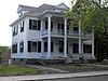 | January 20, 1984 (#84002323) | 478 Prospect St. 42°43′30″N 71°09′29″W / 42.725°N 71.158056°W / 42.725; -71.158056 (Terence Dolan House) | A large Georgian Revival home, typical of houses built in its neighborhood at the beginning of the twentieth century | |
7 | Double-arch Sandstone Bridge |  | June 20, 1984 (#84002326) | Hampshire Rd. 42°44′33″N 71°12′29″W / 42.7425°N 71.208056°W / 42.7425; -71.208056 (Double-arch Sandstone Bridge) | A dry stone arch bridge, built without mortar, over the Spicket River. Parts date back to 1735. Presently in poor condition and in danger of collapse. | |
8 | Emerson House |  | January 20, 1984 (#84002351) | 58 Ayers Village Rd. 42°42′27″N 71°10′19″W / 42.7075°N 71.171944°W / 42.7075; -71.171944 (Emerson House) | A colonial farm house built in 1750 is well preserved and conserves a portion of the original rural landscape.[7] | |
9 | Capt. Oliver Emerson Homestead |  | January 20, 1984 (#84002347) | 133 North St. 42°46′38″N 71°10′50″W / 42.777222°N 71.180556°W / 42.777222; -71.180556 (Capt. Oliver Emerson Homestead) | ||
10 | G.B. Emmons House |  | January 20, 1984 (#84002353) | 283 Broadway 42°43′44″N 71°11′18″W / 42.728889°N 71.188333°W / 42.728889; -71.188333 (G.B. Emmons House) | ||
11 | First Baptist Church |  | January 20, 1984 (#84002365) | 253 Lawrence St. 42°43′41″N 71°11′06″W / 42.728056°N 71.185°W / 42.728056; -71.185 (First Baptist Church) | Built in 1869, the church is a massive example of the Carpenter Gothic style of architecture.[8] | |
12 | First Church Congregational |  | December 1, 1978 (#78000461) | Pleasant and Stevens Sts. 42°43′46″N 71°11′08″W / 42.729444°N 71.185556°W / 42.729444; -71.185556 (First Church Congregational) | ||
13 | Urias Hardy House |  | January 20, 1984 (#84002367) | 50 Brown St. 42°43′23″N 71°10′48″W / 42.723056°N 71.18°W / 42.723056; -71.18 (Urias Hardy House) | ||
14 | House at 15-19 Park Street |  | January 20, 1984 (#84002388) | 15-19 Park St. 42°43′38″N 71°11′05″W / 42.727222°N 71.184722°W / 42.727222; -71.184722 (House at 15-19 Park Street) | ||
15 | House at 10 Park Street |  | January 20, 1984 (#84002385) | 10 Park St. 42°43′34″N 71°11′09″W / 42.726111°N 71.185833°W / 42.726111; -71.185833 (House at 10 Park Street) | The E.M. Clark House built around 1880, is a well-preserved Italianate-style single-family residence. | |
16 | House at 113-115 Center Street |  | January 20, 1984 (#84002381) | 113-115 Center St. 42°43′12″N 71°10′49″W / 42.72°N 71.180278°W / 42.72; -71.180278 (House at 113-115 Center Street) | One of the few surviving examples of an early duplex house seen in approximately six locations throughout the Arlington Mills Historic District. | |
17 | House at 13 Annis Street |  | January 20, 1984 (#84002387) | 13 Annis St. 42°43′11″N 71°10′44″W / 42.719722°N 71.178889°W / 42.719722; -71.178889 (House at 13 Annis Street) | A well-preserved example of the inexpensive dwellings built by speculators for sale to woolen mill workers, a 1 1⁄2-story gable-roofed worker's cottage in the Arlington Mills Historic District, | |
18 | House at 136 Hampstead Street | 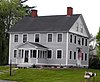 | June 20, 1984 (#84002377) | 136 Hampstead St. 42°46′35″N 71°10′29″W / 42.776389°N 71.174722°W / 42.776389; -71.174722 (House at 136 Hampstead Street) | ||
19 | House at 23 East Street |  | January 20, 1984 (#84002382) | 23 East St. 42°43′34″N 71°10′39″W / 42.726111°N 71.1775°W / 42.726111; -71.1775 (House at 23 East Street) | ||
20 | House at 262-264 Pelham Street |  | January 20, 1984 (#84002390) | 262-264 Pelham St. 42°43′38″N 71°13′31″W / 42.727222°N 71.225278°W / 42.727222; -71.225278 (House at 262-264 Pelham Street) | ||
21 | House at 306 Broadway |  | January 20, 1984 (#84002379) | 306 Broadway 42°43′44″N 71°11′22″W / 42.728889°N 71.189444°W / 42.728889; -71.189444 (House at 306 Broadway) | ||
22 | House at 4 Birch Avenue |  | January 20, 1984 (#84002374) | 4 Birch Ave. 42°43′40″N 71°08′58″W / 42.727778°N 71.149444°W / 42.727778; -71.149444 (House at 4 Birch Avenue) | ||
23 | House at 491 Prospect Street |  | January 20, 1984 (#84002396) | 491 Prospect St. 42°43′39″N 71°09′33″W / 42.7275°N 71.159167°W / 42.7275; -71.159167 (House at 491 Prospect Street) | ||
24 | House at 50 Pelham Street |  | January 20, 1984 (#84002392) | 50 Pelham St. 42°43′32″N 71°11′34″W / 42.725556°N 71.192778°W / 42.725556; -71.192778 (House at 50 Pelham Street) | ||
25 | House at 526 Prospect Street |  | January 20, 1984 (#84002394) | 526 Prospect St. 42°43′45″N 71°09′40″W / 42.729188°N 71.161000°W / 42.729188; -71.161000 (House at 526 Prospect Street) | ||
26 | House at 9 Park Street |  | January 20, 1984 (#84002384) | 9 Park St. 42°43′35″N 71°11′06″W / 42.726389°N 71.185°W / 42.726389; -71.185 (House at 9 Park Street) | ||
27 | Johnson House |  | January 20, 1984 (#84002398) | 8 Ditson Pl. 42°43′38″N 71°11′13″W / 42.727222°N 71.186944°W / 42.727222; -71.186944 (Johnson House) | ||
28 | Lawrence Street Cemetery |  | January 20, 1984 (#84002399) | Lawrence St. 42°43′39″N 71°10′57″W / 42.7275°N 71.1825°W / 42.7275; -71.1825 (Lawrence Street Cemetery) | ||
29 | Methuen Memorial Music Hall |  | December 14, 1978 (#78000462) | 192 Broadway 42°43′30″N 71°11′08″W / 42.725°N 71.185556°W / 42.725; -71.185556 (Methuen Memorial Music Hall) | ||
30 | Methuen Water Works |  | January 20, 1984 (#84002403) | Cross St. 42°44′23″N 71°12′53″W / 42.739722°N 71.214722°W / 42.739722; -71.214722 (Methuen Water Works) | ||
31 | Moses Morse House | 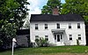 | January 20, 1984 (#84002404) | 311 Pelham St. 42°43′40″N 71°14′01″W / 42.727778°N 71.233611°W / 42.727778; -71.233611 (Moses Morse House) | ||
32 | Nevins Memorial Library |  | January 20, 1984 (#84002407) | 305 Broadway 42°43′52″N 71°11′25″W / 42.731111°N 71.190278°W / 42.731111; -71.190278 (Nevins Memorial Library) | ||
33 | Henry C. Nevins Home for Aged and Incurables | January 20, 1984 (#84002406) | 110 Broadway 42°43′16″N 71°10′58″W / 42.721111°N 71.182778°W / 42.721111; -71.182778 (Henry C. Nevins Home for Aged and Incurables) | Still in operation as the Nevins Nursing & Rehabilitation Centre. | ||
34 | Old Town Farm |  | January 20, 1984 (#84002413) | 430 Pelham St. 42°44′17″N 71°14′33″W / 42.738056°N 71.2425°W / 42.738056; -71.2425 (Old Town Farm) | ||
35 | Park Lodge |  | January 20, 1984 (#84002414) | 257 Lawrence St. 42°43′40″N 71°11′08″W / 42.727778°N 71.185556°W / 42.727778; -71.185556 (Park Lodge) | ||
36 | Joseph Perkins House | 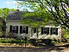 | January 20, 1984 (#84002416) | 297 Howe St. 42°45′40″N 71°10′08″W / 42.761111°N 71.168889°W / 42.761111; -71.168889 (Joseph Perkins House) | ||
37 | Pleasant-High Historic District |  | June 20, 1984 (#84002417) | Roughly bounded by Broadway, High, Vine, Charles, and Pleasant Sts. 42°43′47″N 71°11′09″W / 42.729722°N 71.185833°W / 42.729722; -71.185833 (Pleasant-High Historic District) | ||
38 | Searles High School |  | January 20, 1984 (#84002431) | 41 Pleasant St. 42°43′48″N 71°11′02″W / 42.73°N 71.183889°W / 42.73; -71.183889 (Searles High School) | ||
39 | James E. Simpson House |  | January 20, 1984 (#84002432) | 606 Prospect St. 42°44′17″N 71°09′59″W / 42.738056°N 71.166389°W / 42.738056; -71.166389 (James E. Simpson House) | An American Craftsman Style bungalow | |
40 | Spicket Falls Historic District |  | June 20, 1984 (#84002435) | Roughly bounded by the Spicket River, Railroad, Pelham, Hampshire, Broadway and Osgood Sts. 42°43′36″N 71°11′21″W / 42.726667°N 71.189167°W / 42.726667; -71.189167 (Spicket Falls Historic District) | ||
41 | Asie Swan House |  | January 20, 1984 (#84002437) | 669 Prospect St. 42°44′26″N 71°10′01″W / 42.740556°N 71.166944°W / 42.740556; -71.166944 (Asie Swan House) | ||
42 | Tenney Castle Gatehouse |  | January 20, 1984 (#84002438) | 37 Pleasant St. 42°43′46″N 71°11′04″W / 42.729444°N 71.184444°W / 42.729444; -71.184444 (Tenney Castle Gatehouse) | ||
43 | Turnpike House |  | January 20, 1984 (#84002439) | 314 Broadway 42°43′47″N 71°11′24″W / 42.729722°N 71.19°W / 42.729722; -71.19 (Turnpike House) | The original building no longer exists. It was abandoned and razed.[9] | |
44 | George A. Waldo House |  | January 20, 1984 (#84002441) | 233 Lawrence St. 42°43′39″N 71°11′00″W / 42.7275°N 71.183333°W / 42.7275; -71.183333 (George A. Waldo House) | ||
45 | Walnut Grove Cemetery |  | January 20, 1984 (#84002444) | Grove and Railroads Sts. 42°43′23″N 71°11′27″W / 42.723056°N 71.190833°W / 42.723056; -71.190833 (Walnut Grove Cemetery) |
See also[edit]
| Wikimedia Commons has media related to National Register of Historic Places in Methuen, Massachusetts. |
- List of National Historic Landmarks in Massachusetts
- National Register of Historic Places listings in Essex County, Massachusetts
- National Register of Historic Places listings in Massachusetts
References[edit]
^ The latitude and longitude information provided in this table was derived originally from the National Register Information System, which has been found to be fairly accurate for about 99% of listings. For about 1% of NRIS original coordinates, experience has shown that one or both coordinates are typos or otherwise extremely far off; some corrections may have been made. A more subtle problem causes many locations to be off by up to 150 yards, depending on location in the country: most NRIS coordinates were derived from tracing out latitude and longitudes from USGS topographical quadrant maps created under the North American Datum of 1927, which differs from the current, highly accurate WGS84 GPS system used by most on-line maps. Chicago is about right, but NRIS longitudes in Washington are higher by about 4.5 seconds, and are lower by about 2.0 seconds in Maine. Latitudes differ by about 1.0 second in Florida. Some locations in this table may have been corrected to current GPS standards.
^ National Park Service (2008-04-24). "National Register Information System". National Register of Historic Places. National Park Service..mw-parser-output cite.citation{font-style:inherit}.mw-parser-output q{quotes:"""""""'""'"}.mw-parser-output code.cs1-code{color:inherit;background:inherit;border:inherit;padding:inherit}.mw-parser-output .cs1-lock-free a{background:url("//upload.wikimedia.org/wikipedia/commons/thumb/6/65/Lock-green.svg/9px-Lock-green.svg.png")no-repeat;background-position:right .1em center}.mw-parser-output .cs1-lock-limited a,.mw-parser-output .cs1-lock-registration a{background:url("//upload.wikimedia.org/wikipedia/commons/thumb/d/d6/Lock-gray-alt-2.svg/9px-Lock-gray-alt-2.svg.png")no-repeat;background-position:right .1em center}.mw-parser-output .cs1-lock-subscription a{background:url("//upload.wikimedia.org/wikipedia/commons/thumb/a/aa/Lock-red-alt-2.svg/9px-Lock-red-alt-2.svg.png")no-repeat;background-position:right .1em center}.mw-parser-output .cs1-subscription,.mw-parser-output .cs1-registration{color:#555}.mw-parser-output .cs1-subscription span,.mw-parser-output .cs1-registration span{border-bottom:1px dotted;cursor:help}.mw-parser-output .cs1-hidden-error{display:none;font-size:100%}.mw-parser-output .cs1-visible-error{font-size:100%}.mw-parser-output .cs1-subscription,.mw-parser-output .cs1-registration,.mw-parser-output .cs1-format{font-size:95%}.mw-parser-output .cs1-kern-left,.mw-parser-output .cs1-kern-wl-left{padding-left:0.2em}.mw-parser-output .cs1-kern-right,.mw-parser-output .cs1-kern-wl-right{padding-right:0.2em}
^ https://www.nps.gov/subjects/nationalregister/weekly-list.htm "National Register of Historic Places: Weekly List Actions"]. National Park Service, United States Department of the Interior. Retrieved on October 4, 2018.
^ Numbers represent an ordering by significant words. Various colorings, defined here, differentiate National Historic Landmarks and historic districts from other NRHP buildings, structures, sites or objects.
^ National Park Service (2008-04-24). "National Register Information System". National Register of Historic Places. National Park Service.
^ The eight-digit number below each date is the number assigned to each location in the National Register Information System database, which can be viewed by clicking the number.
^ Gagnon, Dan (2001). "Methuen History.org Historic Sites: A thru B Streets". Retrieved 2009-05-23.
^ Gagnon, Dan (2001). "Methuen History.org Historic Sites: A thru B Streets". Retrieved 2009-05-23.
^ Gagnon, Dan (2001). "Methuen History.org Historic Sites: Lost Methuen". Retrieved 2009-05-23.
U.S. National Register of Historic Places in Massachusetts | |||||||||||||||||
|---|---|---|---|---|---|---|---|---|---|---|---|---|---|---|---|---|---|
| Topics |
|  | |||||||||||||||
| Lists by county |
| ||||||||||||||||
| Lists by city |
| ||||||||||||||||
| Other lists |
| ||||||||||||||||
| |||||||||||||||||
Categories:
- Methuen, Massachusetts
- Lists of National Register of Historic Places in Massachusetts by populated place
- National Register of Historic Places in Methuen, Massachusetts
- Lists of National Register of Historic Places by city
(window.RLQ=window.RLQ||).push(function(){mw.config.set({"wgPageParseReport":{"limitreport":{"cputime":"0.736","walltime":"0.878","ppvisitednodes":{"value":17826,"limit":1000000},"ppgeneratednodes":{"value":0,"limit":1500000},"postexpandincludesize":{"value":296614,"limit":2097152},"templateargumentsize":{"value":19805,"limit":2097152},"expansiondepth":{"value":11,"limit":40},"expensivefunctioncount":{"value":0,"limit":500},"unstrip-depth":{"value":1,"limit":20},"unstrip-size":{"value":16120,"limit":5000000},"entityaccesscount":{"value":1,"limit":400},"timingprofile":["100.00% 564.302 1 -total"," 63.64% 359.098 45 Template:NRHP_row"," 17.58% 99.199 1 Template:NRHP_header"," 16.81% 94.838 5 Template:Cite_web"," 15.12% 85.313 2 Template:NRISref"," 14.85% 83.779 90 Template:First_word"," 13.10% 73.903 46 Template:Designation/color"," 13.05% 73.616 45 Template:Coord"," 12.39% 69.900 49 Template:NRHP_color"," 11.02% 62.168 45 Template:Dts"]},"scribunto":{"limitreport-timeusage":{"value":"0.237","limit":"10.000"},"limitreport-memusage":{"value":3590488,"limit":52428800}},"cachereport":{"origin":"mw1273","timestamp":"20181014001614","ttl":1900800,"transientcontent":false}}});mw.config.set({"wgBackendResponseTime":983,"wgHostname":"mw1273"});});

 Clash Royale CLAN TAG

