List of bridges on the National Register of Historic Places in Massachusetts
List of bridges on the National Register of Historic Places in Massachusetts
Jump to navigation
Jump to search
This is a list of bridges and tunnels on the National Register of Historic Places in the U.S. state of Massachusetts.[1]
| Name | Image | Built | Listed | Location | County | Type |
|---|---|---|---|---|---|---|
Annisquam Bridge |  | 1861, 1896, 1961 | 1983-06-23 | Gloucester 42°39′18″N 70°40′32.4″W / 42.65500°N 70.675667°W / 42.65500; -70.675667 (Annisquam Bridge) | Essex | Wood pile type |
Atherton Bridge |  | 1870 | 1979-09-19 | Lancaster 42°26′40″N 71°40′21″W / 42.44444°N 71.67250°W / 42.44444; -71.67250 (Atherton Bridge) | Worcester | single span Pony/Post Truss |
Bardwell's Ferry Bridge |  | 1882 | 2000-02-10 | Conway 42°33′20″N 72°40′41″W / 42.55556°N 72.67806°W / 42.55556; -72.67806 (Bardwell's Ferry Bridge) | Franklin | |
Bartlett's Bridge | 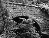 | 1889 | 2000-02-10 | Oxford 42°9′17″N 71°52′59″W / 42.15472°N 71.88306°W / 42.15472; -71.88306 (Bartlett's Bridge) | Worcester | |
Bissell Bridge |  | 2004-02-26 | Charlemont 42°37′57″N 72°52′10″W / 42.63250°N 72.86944°W / 42.63250; -72.86944 (Bissell Bridge) | Franklin | Long Through Truss | |
Blackstone Viaduct |  | 1872, 1918 | 2002-02-05 | Blackstone 42°0′55″N 71°32′0″W / 42.01528°N 71.53333°W / 42.01528; -71.53333 (Blackstone Viaduct) | Worcester | |
Burkeville Covered Bridge |  | 1870, 1871 | 1988-09-09 | Conway 42°29′1″N 72°42′44″W / 42.48361°N 72.71222°W / 42.48361; -72.71222 (Burkeville Covered Bridge) | Franklin | Multiple kingrod truss |
Canton Viaduct |  | 1834 | 1984-09-20 | Canton 42°9′28″N 71°9′17″W / 42.15778°N 71.15472°W / 42.15778; -71.15472 (Canton Viaduct) | Norfolk | |
Carpenter Bridge |  | 1873 | 1983-06-06 | Rehoboth 41°49′41″N 71°15′20″W / 41.82806°N 71.25556°W / 41.82806; -71.25556 (Carpenter Bridge) | Bristol | |
Choate Bridge | 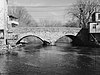 | 1764 | 1972-08-21 | Ipswich 42°40′46″N 70°50′16″W / 42.67944°N 70.83778°W / 42.67944; -70.83778 (Choate Bridge) | Essex | Double stone arch (oldest bridge in the country of its type) |
Coleman Bridge |  | by 1894 | 2000-02-18 | Windsor 42°31′56″N 72°59′36″W / 42.53222°N 72.99333°W / 42.53222; -72.99333 (Coleman Bridge) | Berkshire | Ball-patent Pipe Bridge |
Crossman Bridge |  | 1888 | 2010-12-27 | Warren 42°12′37″N 72°14′44″W / 42.21028°N 72.24556°W / 42.21028; -72.24556 (Crossman Bridge) | Worcester | One of the state's few surviving lenticular pony truss bridge |
Deerfield River Bridge |  | 1890 | 1988-01-28 | Shelburne, Buckland 42°36′13″N 72°44′27″W / 42.6037°N 72.7407°W / 42.6037; -72.7407 (Deerfield River Bridge) | Franklin | A contributing element of the Shelburne Falls Historic District. |
Double-arch Sandstone Bridge |  | 1835 | 1984-06-20 | Methuen 42°44′33″N 71°12′29″W / 42.74250°N 71.20806°W / 42.74250; -71.20806 (Double-arch Sandstone Bridge) | Essex | Mortarless twin arch |
Echo Bridge |  | 1876, 1877 | 1980-04-09 | Needham, Newton 42°18′53″N 71°13′39″W / 42.31472°N 71.22750°W / 42.31472; -71.22750 (Echo Bridge) | Middlesex, Norfolk | |
Eliot Memorial Bridge |  | 1905 | 1980-09-25 | Milton 42°12′42″N 71°6′49″W / 42.21167°N 71.11361°W / 42.21167; -71.11361 (Eliot Memorial Bridge) | Norfolk | |
Bridge of Flowers |  | 1905 | 1988-01-28 | Shelburne, Buckland 42°36′14.67″N 72°44′25.82″W / 42.6040750°N 72.7405056°W / 42.6040750; -72.7405056 (Bridge of Flowers) | Franklin | A contributing element of the Shelburne Falls Historic District. |
Golden Hill Bridge |  | 1994-02-09 | Lee 42°19′18″N 73°14′33″W / 42.32167°N 73.24250°W / 42.32167; -73.24250 (Golden Hill Bridge) | Berkshire | ||
Granite Keystone Bridge |  | 1872 | 1981-08-27 | Rockport 42°40′1″N 70°37′33″W / 42.66694°N 70.62583°W / 42.66694; -70.62583 (Granite Keystone Bridge) | Essex | Stone-arch bridge |
Harris Street Bridge | 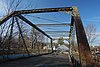 | 1887 | 1984-07-05 | Taunton 41°54′20″N 71°4′12″W / 41.90556°N 71.07000°W / 41.90556; -71.07000 (Harris Street Bridge) | Bristol | Pratt Truss |
Linden Street Bridge |  | 1894 | 1989-09-28 | Waltham 42°22′48″N 71°13′15″W / 42.38000°N 71.22083°W / 42.38000; -71.22083 (Linden Street Bridge) | Middlesex | |
Medford Pipe Bridge | 1897, 1898 | 1990-01-18 | Medford 42°25′6″N 71°6′44″W / 42.41833°N 71.11222°W / 42.41833; -71.11222 (Medford Pipe Bridge) | Middlesex | ||
Middlefield-Becket Stone Arch Railroad Bridge District |  | 1840, ca. 1866, 1912 | 1980-04-11 | Becket, Chester, Middlefield 42°18′44″N 73°1′10″W / 42.31222°N 73.01944°W / 42.31222; -73.01944 (Middlefield-Becket Stone Arch Railroad Bridge) | Berkshire, Hampden, Hampshire | |
Needham Street Bridge | 1875 | 1986-09-04 | Needham, Newton 42°18′23″N 71°13′3″W / 42.30639°N 71.21750°W / 42.30639; -71.21750 (Needham Street Bridge) | Middlesex, Norfolk | Stone-arch bridge | |
Newton Street Bridge |  | 1877 | 1989-09-28 | Waltham 42°22′20″N 71°13′45″W / 42.37222°N 71.22917°W / 42.37222; -71.22917 (Newton Street Bridge) | Middlesex | Triple-arch stone bridge |
Old Covered Bridge | 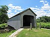 | 1837, 1838 | 1978-11-24 | Sheffield 42°7′26″N 73°21′17″W / 42.12389°N 73.35472°W / 42.12389; -73.35472 (Old Covered Bridge) | Berkshire | Town Lattice Truss Bridge |
Old Town Bridge |  | 1848; reconstructed 1900 | 1975-05-02 | Wayland 42°22′31″N 71°22′49″W / 42.37528°N 71.38028°W / 42.37528; -71.38028 (Old Town Bridge) | Middlesex | Stone arch bridge |
Paul's Bridge |  | 1849, ca. 1935 | 1972-12-11 | Boston, Milton 42°14′4″N 71°7′24″W / 42.23444°N 71.12333°W / 42.23444; -71.12333 (Paul's Bridge) | Norfolk, Suffolk | |
Ponakin Bridge |  | 1871 | 1979-09-10 | Lancaster 42°28′52″N 71°41′9″W / 42.48111°N 71.68583°W / 42.48111; -71.68583 (Ponakin Bridge) | Worcester | Post Through Truss |
Quinepoxet River Bridge | 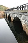 | 1903 | 1990-04-08 | West Boylston 42°23′6″N 71°47′52″W / 42.38500°N 71.79778°W / 42.38500; -71.79778 (Quinepoxet River Bridge) | Worcester | |
Arthur A. Smith Covered Bridge |  | 1868, 1870, 1896 | 1983-02-03 | Colrain 42°40′12″N 72°43′9″W / 42.67000°N 72.71917°W / 42.67000; -72.71917 (Arthur A. Smith Covered Bridge) | Franklin | Burr arch truss system |
Stone's Bridge |  | 1858 | 2017-01-17 | Wayland and Framingham 42°20′21″N 71°23′42″W / 42.33917°N 71.39500°W / 42.33917; -71.39500 (Stone's Bridge) | Middlesex | Stone arch bridge |
Waban Arches Bridge |  | 1875 | 1991-01-18 | Wellesley 42°16′58″N 71°17′51″W / 42.2829°N 71.2974°W / 42.2829; -71.2974 (Waban Arches Bridge) | Norfolk | Part of the Sudbury Aqueduct Linear District; this bridge carries the aqueduct over Waban Brook. |
Wachusett Aqueduct | 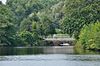 | 1896 | 1991-01-18 | Southborough 42°18′18″N 71°32′32″W / 42.305°N 71.5421°W / 42.305; -71.5421 (Wachusett Aqueduct (Deerfoot Road bridge)) | Worcester | The Wachusett Aqueduct is carried over at least one bridge, and a number of bridges carrying roads (or former roads) over the aqueduct's open channel are contributing structures to its listing on the National Register. The pictured bridge carries Deerfoot Road over the open channel. |
Walden Street Cattle Pass |  | 1857, 1869 | 1994-06-03 | Cambridge 42°23′21″N 71°7′31″W / 42.38917°N 71.12528°W / 42.38917; -71.12528 (Walden Street Cattle Pass) | Middlesex | |
Ware-Hardwick Covered Bridge |  | 1886 | 1986-05-08 | Hardwick, Ware 42°18′37″N 72°12′45″W / 42.31028°N 72.21250°W / 42.31028; -72.21250 (Ware-Hardwick Covered Bridge) | Hampshire, Worcester | Town lattice truss |
References[edit]
^ National Park Service (2010-07-09). "National Register Information System". National Register of Historic Places. National Park Service..mw-parser-output cite.citation{font-style:inherit}.mw-parser-output q{quotes:"""""""'""'"}.mw-parser-output code.cs1-code{color:inherit;background:inherit;border:inherit;padding:inherit}.mw-parser-output .cs1-lock-free a{background:url("//upload.wikimedia.org/wikipedia/commons/thumb/6/65/Lock-green.svg/9px-Lock-green.svg.png")no-repeat;background-position:right .1em center}.mw-parser-output .cs1-lock-limited a,.mw-parser-output .cs1-lock-registration a{background:url("//upload.wikimedia.org/wikipedia/commons/thumb/d/d6/Lock-gray-alt-2.svg/9px-Lock-gray-alt-2.svg.png")no-repeat;background-position:right .1em center}.mw-parser-output .cs1-lock-subscription a{background:url("//upload.wikimedia.org/wikipedia/commons/thumb/a/aa/Lock-red-alt-2.svg/9px-Lock-red-alt-2.svg.png")no-repeat;background-position:right .1em center}.mw-parser-output .cs1-subscription,.mw-parser-output .cs1-registration{color:#555}.mw-parser-output .cs1-subscription span,.mw-parser-output .cs1-registration span{border-bottom:1px dotted;cursor:help}.mw-parser-output .cs1-hidden-error{display:none;font-size:100%}.mw-parser-output .cs1-visible-error{font-size:100%}.mw-parser-output .cs1-subscription,.mw-parser-output .cs1-registration,.mw-parser-output .cs1-format{font-size:95%}.mw-parser-output .cs1-kern-left,.mw-parser-output .cs1-kern-wl-left{padding-left:0.2em}.mw-parser-output .cs1-kern-right,.mw-parser-output .cs1-kern-wl-right{padding-right:0.2em}
U.S. National Register of Historic Places in Massachusetts | |||||||||||||||||
|---|---|---|---|---|---|---|---|---|---|---|---|---|---|---|---|---|---|
| Topics |
|  | |||||||||||||||
| Lists by county |
| ||||||||||||||||
| Lists by city |
| ||||||||||||||||
| Other lists |
| ||||||||||||||||
| |||||||||||||||||
Categories:
- Bridges on the National Register of Historic Places in Massachusetts
- Lists of National Register of Historic Places in Massachusetts
- Lists of bridges on the National Register of Historic Places by state
- Massachusetts transportation-related lists
- Lists of buildings and structures in Massachusetts
(window.RLQ=window.RLQ||).push(function(){mw.config.set({"wgPageParseReport":{"limitreport":{"cputime":"0.384","walltime":"0.474","ppvisitednodes":{"value":2218,"limit":1000000},"ppgeneratednodes":{"value":0,"limit":1500000},"postexpandincludesize":{"value":133832,"limit":2097152},"templateargumentsize":{"value":216,"limit":2097152},"expansiondepth":{"value":8,"limit":40},"expensivefunctioncount":{"value":0,"limit":500},"unstrip-depth":{"value":1,"limit":20},"unstrip-size":{"value":2703,"limit":5000000},"entityaccesscount":{"value":0,"limit":400},"timingprofile":["100.00% 200.138 1 -total"," 37.79% 75.623 36 Template:Coord"," 33.22% 66.480 1 Template:Reflist"," 28.96% 57.953 1 Template:NRISref"," 27.60% 55.246 1 Template:Cite_web"," 16.12% 32.261 3 Template:Navbox"," 10.51% 21.026 1 Template:National_Register_of_Historic_Places_in_Massachusetts"," 6.84% 13.686 7 Template:NRHP_color"," 6.22% 12.443 1 Template:NRHP_bridges"," 5.68% 11.364 1 Template:Designation/color"]},"scribunto":{"limitreport-timeusage":{"value":"0.105","limit":"10.000"},"limitreport-memusage":{"value":2490332,"limit":52428800}},"cachereport":{"origin":"mw1332","timestamp":"20181013210029","ttl":1900800,"transientcontent":false}}});mw.config.set({"wgBackendResponseTime":104,"wgHostname":"mw1328"});});

 Clash Royale CLAN TAG

