Jasper County, Missouri
Jasper County, Missouri
Jump to navigation
Jump to search
Jasper County, Missouri | |
|---|---|
 Jasper County Courthouse in Carthage (August 2008) | |
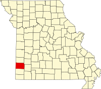 Location in the U.S. state of Missouri | |
 Missouri's location in the U.S. | |
| Founded | January 2, 1841 |
| Named for | William Jasper |
| Seat | Carthage |
| Largest city | Joplin |
| Area | |
| • Total | 641 sq mi (1,660 km2) |
| • Land | 638 sq mi (1,652 km2) |
| • Water | 2.8 sq mi (7 km2), 0.4% |
| Population (est.) | |
| • (2015) | 118,596 |
| • Density | 184/sq mi (71/km2) |
| Congressional district | 7th |
| Time zone | Central: UTC−6/−5 |
| Website | www.jaspercounty.org |
Coordinates: 37°12′N 94°20′W / 37.20°N 94.34°W / 37.20; -94.34
Jasper County is a county located in the southwest portion of the U.S. state of Missouri. As of the 2010 census, the population was 117,404.[1] Its county seat is Carthage,[2] and its largest city is Joplin. The county was organized in 1841 and named for William Jasper, a hero of the American Revolutionary War.
Jasper County is included in the Joplin, MO Metropolitan Statistical Area. The Jasper County Sheriffs office has jurisdiction throughout the county.
Contents
1 History
1.1 Osage Nation
1.2 Missouri Territory
1.3 County organization
1.4 Towns established prior to the Civil War
2 Geography
2.1 Adjacent counties
2.2 Major highways
3 Demographics
4 Education
4.1 Public schools
4.2 Private schools
4.3 Post-secondary
4.4 Public libraries
5 Politics
5.1 Local
5.2 State
5.3 Federal
6 Communities
6.1 Cities
6.2 Villages
6.3 Unincorporated communities
6.4 Former community
6.5 Townships
7 See also
8 References
9 External links
History[edit]

Portrait of an Osage warrior, painted by George Catlin in 1834.
Osage Nation[edit]
Before European contact, the area that today makes up Jasper County was the domain of the Osage Native Americans who called themselves the Children of the Middle Waters (Ni-U-Kon-Ska).[3] This was probably[citation needed] because their dominion encompassed the land between the Missouri and Osage rivers to the north, the Mississippi River to the east, and the Arkansas River to the south. To the west were the Great Plains where they hunted buffalo. By the late 17th century, the Osage were calling themselves Wah-Zha-Zhe.[citation needed]
The earliest record of European-Osage contact is a 1673 map by French Jesuit priest and explorer Jacques Marquette. He noted the people he encountered as the Ouchage, his way of expressing the sound of the name with French spelling.[4] A few years after the Marquette expedition, French explorers discovered a Little Osage village and called it Ouazhigi.[5] French transliterations of the tribe's name settled on a spelling of Osage, which was also used by European Americans.[6]
In 1682 Robert de La Salle canoed down the length of the Mississippi River to the Gulf of Mexico, naming the entire Mississippi basin “La Louisiane” in honor of King Louis XIV. In 1699 Louisiana was named an administrative district of New France therefore, as far as the Europeans (France, England and Spain) were concerned, the area of Jasper County was French territory. The French further divided the Louisiana district into an upper and lower parts with the Arkansas River being the dividing line.
With France and Spain’s defeat in the Seven Years' War in 1763, France ceded Louisiana to Spain and most of the rest of New France to the British who also received Florida from Spain. The Spanish District of New Madrid, containing present day Jasper County, was the southernmost of the five Spanish districts comprising Upper Louisiana. France regained control of Louisiana through the secret Treaty of San Ildefonso in 1800 but Napoleon Bonaparte I decided to sell the territory to the United States in 1803.
The Osage began treaty-making with the United States in 1808 with the first cession of lands in Missouri in the (Osage Treaty). The Osage moved from their homelands on the Osage River in 1808 to the Jasper County area of Southwest Missouri. In 1825, the Osages ceded their traditional lands across Missouri, Arkansas, and Oklahoma. They were first moved onto a southeastern Kansas reservation in the Cherokee Strip, on which the city of Independence, Kansas now sits and finally to Indian Territory in 1872.
Missouri Territory[edit]

Map defining borders of Missouri Territory, 1812.
The Upper Louisiana Territory, including the Jasper County area, was renamed the Missouri Territory on June 4, 1812 to avoid confusion with the state of Louisiana which joined the Union in 1812, and the New Madrid District became New Madrid County. Old Lawrence County was established in 1815 from New Madrid County west of the St. Francis River and north of Arkansas County and consisted of all of present-day southwestern Missouri and part of northwestern Arkansas.
Lawrence County was short-lived, however, as three years later (1818) it was combined with part of Cape Girardeau County and renamed Wayne County. By 1819, Arkansas Territory had been created, and Wayne County lost some of its area but still consisted of most of southern Missouri from present-day Wayne County west to the Kansas State Line and south along the Arkansas State Line.
In 1820, all of Missouri Territory was admitted to the Union as the state of Missouri, and in 1831 Crawford County was carved out of the original Wayne. This new division covered all of the southern part of Missouri and included Jasper County in its boundaries. This alignment was also short-lived as in 1833 Greene County was split from Crawford County from the Niangua River west to the Kansas State Line.
On January 5, 1835, a big piece was cut out of Greene County and organized as Barry County. In 1838 Barry County was divided into four parts called Barry, Dade, Newton and Jasper counties. At this time Jasper was not a full-fledged county but was attached to Newton County and it would not be until 1841.
County organization[edit]

Log home of George Hornback, used as the initial Jasper County Courthouse in 1841. It has been preserved and can be viewed on the grounds of the Old Cabin Shop at 155 North Black Powder Lane, off of West Mound Street in Carthage.
On January 29, 1841, the Missouri Legislature enacted a bill authorizing the organization of Jasper County and was named in honor of Sergeant William Jasper, a hero in the American Revolutionary War.[7][8] The Jasper County Court first divided the area into three townships: North Fork, Center Creek and Marion, but later it was divided into 15 townships which remain in an unincorporated status to the present time.
A temporary seat of justice was established, Thursday, February 25, 1841 in the home of George Hornback. It was a 12×16 foot log cabin, one and a half miles northwest of Carthage on Spring River. The officers of the court were Charles S. Yancey, judge, and Elwood B. James, clerk. Mount Vernon attorney Robert W. Crawford was appointed circuit attorney pro tem. John P. Osborn, the first sheriff, was ordered to give public notice that the county court of Jasper County would meet in the home of George Hornback until the permanent seat of justice was established. The first session of the court was two days; the proceedings covered four pages of record.
A permanent county seat was chosen in March 1842 and designated by the name of Carthage. A one-story single-room wooden structure with a large door in the south, was completed on June 29, 1842, and was located on the north side of the present public square in Carthage. This courthouse was later replaced by a larger two-story brick-and-stone structure that was completed in 1854, which also functioned as the county jail. At the second term of the court held in October of the same year, attorneys Robert W. Crawford and John R. Chenault were cited for contempt and fined the sum of ten dollars for "fighting in the presence and view of said court during the said sitting."[9]
At the March 1861 Secession Convention held in Jefferson City, Chenault represented Jasper County while Crawford represented Lawrence County. Possibly for their own self-preservation, and to buy time to make preparations in Southwest Missouri for the inevitable war that would soon ravage both of these border counties, the two former adversaries voted in favor of keeping Missouri in the Union. Missouri was the only state to hold a convention on secession and then vote to remain in the Union.[10]

Cave Spring School, the site of Jasper County circuit court in 1865, is located at 4323 County Road 4 near La Russell.
At the outset of the war Chenault, by then a circuit court judge, moved with his family to Texas. Following the Battle of Carthage, on July 12, 1861 Crawford was elected Lieutenant Colonel of the 13th Missouri Cavalry Regiment and 5th Missouri Infantry, both of the 8th Division, Missouri State Guard.[11] After leading the 13th Cavalry Regiment into numerous battles, in a command that included two of his sons in first lieutenant and quartermaster ranks, Crawford moved his noncombatant family to Texas; he then served as a recruiter for the Confederate Army in Missouri, a post he was nominated for by Waldo P. Johnson, formerly a United States Senator from Missouri in a letter to Missouri governor-in-exile Claiborne Fox Jackson dated October 24, 1862.[12][13]
By the start of the American Civil War in 1861 there were several small river mill settlements, some mining camps and about nine or ten towns (seven platted) in Jasper County, Missouri. The county seat of Carthage, Missouri had an estimated population between four and five hundred at that time. The newer brick courthouse was used as a hospital during the American Civil War and was destroyed by fire during fighting in October 1863. By the end of the Civil War, Carthage had been evacuated and completely destroyed, and much of Jasper County laid in ruins. Other than military tribunals no courts were held in Jasper County between May 11, 1861 and October 10, 1865.
By order of the Governor in 1865, the courthouse was relocated to the pioneer schoolhouse at Cave Springs (near present-day La Russell, Missouri) with John C. Price of Mount Vernon appointed as the circuit court judge. Price later (before?) served as treasurer of the United States under President Buchanan.[14] Other temporary locations within the county were later used over the next three decades until the current Jasper County Courthouse was constructed on the Carthage square in the mid-1890s.[15]
The county adopted an official flag in 2001, which was unveiled during the county's 160th birthday celebration. The flag depicts the county courthouse surrounded by 15 stars representing Jasper County’s 15 townships. The center blue and red stars memorialize the struggle in Jasper County during the Civil War years, including the Battle of Carthage in 1861 and second battle in 1863.
Towns established prior to the Civil War[edit]
,[16][17]
| Current Town Name | Accepted Date Founded | Official Date of Plat | Notes |
|---|---|---|---|
Sarcoxie | 1833 | 1840 | The first settlement in Jasper County Missouri, initially known as Centerville. The first settler was Thackeray Vivion in 1831. |
| (Old) Jasper | 1840 | 1842 | Was located northeast of Carthage and no longer exists. Later, another settlement named Jasper existed southeast of Carthage. The present town of Jasper, Missouri, north of Carthage, is a different community previously known as Coon Creek settlement or "Midway." |
Carthage | 1841 | 1842 | Historic Carthage was planned from the start with the purpose of being the Jasper County seat and was promptly rebuilt after being completely destroyed during the Civil War. The current Jasper County Courthouse was erected in the mid-1890s. |
| (Old) Sherwood | 1846 | 1856 | First called Rural and was located near present-day Webb City. It was not rebuilt after being destroyed during the Civil War and no longer exists. |
Oronogo | 1848 | 1856 | Known as Minersville around the time of the Civil War, it evolved from early mining camps and had other names such as Leadville Hollow. The Post Office had also used the name Center Mines. |
| (Old) Medoc | 1848 | After the Civil War | Started as an old Indian trading post near the Kansas state line, it was destroyed during the Civil War and later resettled, but the plat was abandoned by the 20th century and the town no longer exists. |
Avilla | 1856 | 1858 | Founded by merchant-landowners as a business center on the edge of the frontier in the mid-1850s. The citizens of Avilla formed a town militia for defense at the beginning of the Civil War and the site later served as a Union Army garrison (Enrolled Missouri Militia), subsequently prevailing intact and undamaged after the war. The town's growth was ultimately stunted after being bypassed by the railroad in the latter 19th century and it remains a small village in the 21st century today. |
Fidelity | 1856 | After the Civil War | Considered to have been founded by William Cloe about the same time as Avilla for similar reasons (mirroring it in some ways), Fidelity was not platted until after the Civil War. |
Waco | 1857 | After the Civil War, 1878 | Started as an old trading post first known as Loshick |
| (Old) Preston | 1859 | 1860 | A village northwest of Carthage, plat abandoned and town no longer exists. |
Geography[edit]
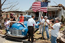
President Barack Obama greets a tornado survivor on May 29, 2011 in Joplin.
According to the U.S. Census Bureau, the county has a total area of 641 square miles (1,660 km2), of which 638 square miles (1,650 km2) is land and 2.8 square miles (7.3 km2) (0.4%) is water.[18]
On Sunday, May 22, 2011 Jasper County was struck in Joplin with a catastrophic EF5 multiple-vortex tornado. The 2011 Joplin tornado ranked as the seventh deadliest in America's history.
Adjacent counties[edit]
Barton County (north)
Dade County (northeast)
Lawrence County (east)
Newton County (south)
Cherokee County, Kansas (west)
Crawford County, Kansas (northwest)
Major highways[edit]
 Interstate 44
 Interstate 49
 U.S. Route 66 (1926–1985)
 U.S. Route 71
 Route 37
 Route 43
 Route 66
 Route 96
 Route 171
 Route 249
Demographics[edit]
| Historical population | |||
|---|---|---|---|
| Census | Pop. | %± | |
| 1850 | 4,223 | — | |
| 1860 | 6,883 | 63.0% | |
| 1870 | 14,928 | 116.9% | |
| 1880 | 32,019 | 114.5% | |
| 1890 | 50,500 | 57.7% | |
| 1900 | 84,018 | 66.4% | |
| 1910 | 89,673 | 6.7% | |
| 1920 | 75,941 | −15.3% | |
| 1930 | 73,810 | −2.8% | |
| 1940 | 78,705 | 6.6% | |
| 1950 | 79,106 | 0.5% | |
| 1960 | 78,863 | −0.3% | |
| 1970 | 79,852 | 1.3% | |
| 1980 | 86,958 | 8.9% | |
| 1990 | 90,465 | 4.0% | |
| 2000 | 104,686 | 15.7% | |
| 2010 | 117,404 | 12.1% | |
| Est. 2017 | 120,217 | [19] | 2.4% |
| U.S. Decennial Census[20] 1790-1960[21] 1900-1990[22] 1990-2000[23] 2010-2015[1] | |||
As of the census[2] of 2010, there were 117,404 people, 45,639 households, and 30,202 families residing in the county. The population density was 164 people per square mile (63/km²). There were 50,668 housing units at an average density of 71 per square mile (28/km²). The racial makeup of the county was 88.24% White, 1.93% Black or African American, 1.51% Native American, 0.99% Asian, 0.25% Pacific Islander, 3.89% from other races, and 3.18% from two or more races. Approximately 6.84% of the population were Hispanic or Latino of any race.
There were 45,639 households out of which 30.8% had children under the age of 18 living with them, 48.7% were married couples living together, 12.4% had a female householder with no husband present, and 33.8% were non-families. 33.4% of all households were made up of individuals and 24.8% had someone living alone who was 65 years of age or older. The average household size was 2.52 and the average family size was 3.05
In the county, the population was spread out with 27.17% under the age of 19, 7.4% from 20 to 24, 25.11% from 25 to 44, 22.24% from 45 to 64, and 12.14% who were 65 years of age or older. The median age was 35.1 years. For every 100 females, there were 94.10 males. For every 100 females age 18 and over, there were 90.20 males.
The median income for a household in the county was $31,323, and the median income for a family was $37,611. Males had a median income of $28,573 versus $20,386 for females. The per capita income for the county was $16,227. About 10.40% of families and 14.50% of the population were below the poverty line, including 19.20% of those under age 18 and 10.30% of those age 65 or over.
Education[edit]
Public schools[edit]
Avilla R-XIII School District – Avilla
- Avilla Elementary/Middle School (K-08)
Carl Junction R-I School District – Carl Junction
- Carl Junction Primary School (K-01)
- Carl Junction Primary School (02-03)
- Carl Junction Intermediate School (04-06)
- Carl Junction Junior High School (07-08)
- Carl Junction High School (09-12)
Carthage R-IX School District – Carthage
- Columbian Elementary School (PK-04)
- Fairview Elementary School (PK-04)
- Mark Twain Elementary School (PK-04)
- Pleasant Valley Elementary School (PK-04)
- Steadley Elementary School (PK-04)
- Carthage Middle School (05-06)
- Carthage Junior High School (07-08)
Carthage High School (09-12)
Jasper R-V School District – Jasper
- Jasper County Elementary School (K-06)
- Jasper High School (07-12)
Joplin R-VIII School District – Joplin
- Memorial Education Center (PK)
- Cecil Floyd Elementary School (K-05)
- Columbia Elementary School (K-05)
- Soaring Heights Elementary School (K-05)
- Eastmorland Elementary School (PK-05)
- Irving Elementary School (K-05)
- Jefferson Elementary School (K-05)
- Kelsey Norman Elementary School (K-05)
- McKinley Elementary School (K-05)
- Royal Heights Elementary School (K-05)
- Stapleton Elementary School (K-05)
- West Central Elementary School (K-05)
- East Middle School (06-08)
- North Middle School (06-08)
- South Middle School (06-08)
Joplin High School (09-12)
Sarcoxie R-II School District – Sarcoxie
- Wildwood Elementary School (PK-05)
- Sarcoxie High School (06-12)
Webb City R-VII School District – Webb City
- Franklin Early Childhood Center (PK)
- Madge T. James Kindergarten Center (PK-K)
- Bess Truman Primary Center (K-01)
- Webster Primary Center (01-02)
- Carterville Elementary School (PK-04)
- Eugene Field Elementary School (03-04)
- Harry S. Truman Elementary School (02-04)
- Mark Twain Elementary School (03-04)
- Webb City Middle School (05-06)
- Webb City Junior High School (07-08)
Webb City High School (09-12)
Private schools[edit]
Thomas Jefferson Independent Day School – Joplin (K-12) – Nonsectarian (Special Education)
Joplin Area Catholic Schools – Joplin (PK-12) – Roman Catholic
- St. Mary’s Elementary School (PK-05)
- St. Peter’s Middle School (06-08)
- McAuley Catholic High School (09-12)
Martin Luther School – Joplin (PK-08) – Lutheran
College Heights Christian School – Joplin (PK-12) – Nondenominational Christian
St. Ann’s Catholic School – Carthage (PK-06) – Roman Catholic
Post-secondary[edit]
Missouri Southern State University - Joplin. A public, four-year university.
Public libraries[edit]
- Carthage Public Library[24]
- Joplin Public Library[25]
- Sarcoxie Public Library[26]
- Webb City Public Library[27]
Politics[edit]
This section does not cite any sources. (June 2014) (Learn how and when to remove this template message) |
Local[edit]
The Republican Party completely controls politics at the local level in Jasper County. Republicans hold every elected position in the county.
In 2016, Hillary Clinton received 21.9% of the vote in Jasper County, lower than any Democratic presidential candidate in the county's history.
| Jasper County, Missouri | ||||
|---|---|---|---|---|
| Elected countywide officials | ||||
Assessor | Connie Hoover | Republican | ||
Circuit Clerk | Melissa Holcomb | Republican | ||
County Clerk | Marilyn Baugh | Republican | ||
Collector | Stephen H. Holt | Republican | ||
Commissioner (Presiding) | John Bartosh | Republican | ||
Commissioner (District 1) | Tom Flanigan | Republican | ||
Commissioner (District 2) | Darieus K. Adams | Republican | ||
Coroner | Rob Chappel | Republican | ||
Prosecuting Attorney | Theresa Kenney | Republican | ||
Public Administrator | Angela Casavecchia | Republican | ||
Recorder | Charlotte Pickering | Republican | ||
Sheriff | Randee Kaiser | Republican | ||
Treasurer | Denise Rohr | Republican | ||
State[edit]
| Year | Republican | Democratic | Third Parties |
|---|---|---|---|
2016 | 69.11% 33,436 | 27.36% 13,236 | 3.53% 1,710 |
2012 | 53.78% 24,218 | 43.21% 19,457 | 3.01% 1,356 |
2008 | 58.61% 27,764 | 39.42% 18,676 | 1.97% 932 |
2004 | 74.54% 33,293 | 24.30% 10,853 | 1.16% 519 |
2000 | 65.31% 24,335 | 32.75% 12,203 | 1.94% 721 |
1996 | 56.55% 18,977 | 40.63% 13,637 | 2.82% 946 |
Jasper County is divided into four districts in the Missouri House of Representatives, all of which are held by Republicans.
- District 127 — Mike Kelley (R-Lamar) Consists of the communities of Alba, Asbury, Avilla, Carytown, Jasper, La Russell, Neck City, Purcell, Reeds, Sarcoxie, and Waco.
| Party | Candidate | Votes | % | ± | |
|---|---|---|---|---|---|
Republican | Mike Kelley | 5,690 | 85.10% | -14.90 | |
Independent | George R. Parsons | 996 | 14.90% | +14.90 | |
| Party | Candidate | Votes | % | ± | |
|---|---|---|---|---|---|
Republican | Mike Kelley | 3,034 | 100.00% | ||
| Party | Candidate | Votes | % | ± | |
|---|---|---|---|---|---|
Republican | Mike Kelley | 5,857 | 100.00% | ||
- District 161 — Bill White (R-Joplin) Consists of the communities of Duquesne and part of Joplin.
| Party | Candidate | Votes | % | ± | |
|---|---|---|---|---|---|
Republican | Bill White | 8,953 | 100.00% | +27.55 | |
| Party | Candidate | Votes | % | ± | |
|---|---|---|---|---|---|
Republican | Bill White | 3,092 | 72.45% | -27.55 | |
Democratic | Charles Shields | 1,176 | 27.55% | +27.55 | |
| Party | Candidate | Votes | % | ± | |
|---|---|---|---|---|---|
Republican | Bill White | 7,789 | 100.00% | ||
- District 162 — Charlie Davis (R-Webb City) Consists of the communities of Airport Drive, Duenweg, and parts of Carl Junction, Carterville, Joplin, and Webb City.
| Party | Candidate | Votes | % | ± | |
|---|---|---|---|---|---|
Republican | Charlie Davis | 13,941 | 100.00% | ||
| Party | Candidate | Votes | % | ± | |
|---|---|---|---|---|---|
Republican | Charlie Davis | 6,263 | 100.00% | ||
| Party | Candidate | Votes | % | ± | |
|---|---|---|---|---|---|
Republican | Charlie Davis | 12,893 | 100.00% | ||
- District 163 — Cody Smith (R-Carthage) Consists of communities of Carthage, Fidelity, Oronogo, and parts of Carl Junction, Carterville, and Webb City.
| Party | Candidate | Votes | % | ± | |
|---|---|---|---|---|---|
Republican | Cody Smith | 13,502 | 100.00% | +17.68 | |
| Party | Candidate | Votes | % | ± | |
|---|---|---|---|---|---|
Republican | Tom Flanigan | 5,850 | 82.32% | -17.68 | |
Democratic | Michael Jarrett | 1,256 | 17.68% | +17.68 | |
| Party | Candidate | Votes | % | ± | |
|---|---|---|---|---|---|
Republican | Tom Flanigan | 12,663 | 100.00% | ||
All of Jasper County is a part of Missouri’s 32nd District in the Missouri Senate and is represented by Ron Richard (R-Joplin).
| Party | Candidate | Votes | % | ± | |
|---|---|---|---|---|---|
Republican | Ron Richard | 19,362 | 100.00% | ||
Federal[edit]
| Party | Candidate | Votes | % | ± | |
|---|---|---|---|---|---|
Republican | Roy Blunt | 32,123 | 66.35% | +11.47 | |
Democratic | Jason Kander | 13,799 | 28.50% | -10.56 | |
Libertarian | Jonathan Dine | 1,240 | 2.56% | -3.50 | |
Green | Johnathan McFarland | 552 | 1.14% | +1.14 | |
Constitution | Fred Ryman | 699 | 1.44% | +1.44 | |
| Party | Candidate | Votes | % | ± | |
|---|---|---|---|---|---|
Republican | Todd Akin | 24,563 | 54.88% | ||
Democratic | Claire McCaskill | 17,485 | 39.06% | ||
Libertarian | Jonathan Dine | 2,713 | 6.06% | ||
All of Jasper County is included in Missouri's 7th Congressional District and is represented by Billy Long (R-Springfield) in the U.S. House of Representatives.
| Party | Candidate | Votes | % | ± | |
|---|---|---|---|---|---|
Republican | Billy Long | 33,855 | 70.83% | -1.81 | |
Democratic | Genevieve Williams | 11,681 | 24.51% | +2.61 | |
Libertarian | Benjamin T. Brixey | 2,218 | 4.65% | -0.77 | |
| Party | Candidate | Votes | % | ± | |
|---|---|---|---|---|---|
Republican | Billy Long | 15,989 | 72.64% | +4.43 | |
Democratic | Jim Evans | 4,819 | 21.90% | -5.56 | |
Libertarian | Kevin Craig | 1,193 | 5.42% | +1.09 | |
Write-in | Write-ins | 9 | 0.04% | +0.04 | |
| Party | Candidate | Votes | % | ± | |
|---|---|---|---|---|---|
Republican | Billy Long | 30,145 | 68.21% | ||
Democratic | Jim Evans | 12,138 | 27.46% | ||
Libertarian | Kevin Craig | 1,913 | 4.33% | ||
| Year | Republican | Democratic | Third parties |
|---|---|---|---|
2016 | 72.6% 35,070 | 21.9% 10,572 | 5.6% 2,684 |
2012 | 69.3% 31,349 | 28.3% 12,809 | 2.3% 1,060 |
2008 | 65.7% 31,667 | 32.6% 15,730 | 1.7% 822 |
2004 | 70.6% 31,846 | 28.8% 13,002 | 0.5% 237 |
2000 | 66.4% 24,899 | 31.3% 11,737 | 2.3% 845 |
1996 | 54.4% 18,361 | 34.0% 11,462 | 11.7% 3,938 |
1992 | 49.0% 17,592 | 32.7% 11,727 | 18.3% 6,553 |
1988 | 63.9% 19,934 | 35.8% 11,159 | 0.3% 94 |
1984 | 71.4% 23,066 | 28.6% 9,259 | |
1980 | 62.5% 21,664 | 34.5% 11,953 | 3.0% 1,049 |
1976 | 53.2% 17,086 | 46.4% 14,910 | 0.5% 153 |
1972 | 74.6% 22,482 | 25.4% 7,652 | |
1968 | 54.2% 16,794 | 35.5% 10,987 | 10.3% 3,181 |
1964 | 46.2% 15,481 | 53.8% 18,045 | |
1960 | 59.3% 21,804 | 40.7% 14,962 | |
1956 | 60.4% 20,414 | 39.6% 13,404 | |
1952 | 61.0% 23,065 | 38.8% 14,665 | 0.2% 82 |
1948 | 48.5% 14,593 | 51.2% 15,404 | 0.3% 81 |
1944 | 56.8% 17,301 | 43.0% 13,111 | 0.2% 63 |
1940 | 50.5% 18,755 | 49.2% 18,249 | 0.3% 107 |
1936 | 41.8% 14,440 | 57.3% 19,822 | 0.9% 323 |
1932 | 39.8% 11,788 | 58.6% 17,349 | 1.6% 467 |
1928 | 70.9% 20,587 | 28.5% 8,292 | 0.6% 180 |
1924 | 55.1% 13,701 | 36.9% 9,176 | 8.0% 1,983 |
1920 | 58.4% 17,074 | 37.7% 11,006 | 3.9% 1,145 |
1916 | 44.5% 9,358 | 50.0% 10,513 | 5.5% 1,166 |
1912 | 27.4% 4,571 | 40.6% 6,789 | 32.0% 5,344 |
1908 | 49.0% 9,143 | 43.6% 8,130 | 7.4% 1,379 |
1904 | 50.5% 7,851 | 38.7% 6,006 | 10.8% 1,680 |
1900 | 45.9% 8,747 | 50.7% 9,658 | 3.4% 647 |
1896 | 40.4% 4,835 | 58.7% 7,026 | 0.9% 111 |
1892 | 44.2% 5,369 | 39.6% 4,805 | 16.3% 1,976 |
1888 | 48.9% 4,522 | 39.8% 3,684 | 11.3% 1,042 |
Communities[edit]
Cities[edit]
- Alba
- Asbury
- Carl Junction
- Carterville
Carthage (county seat)- Duenweg
- Jasper
- Joplin
- La Russell
- Neck City
- Oronogo
- Purcell
- Reeds
- Sarcoxie
- Waco
- Webb City
Villages[edit]
- Airport Drive
- Avilla
- Brooklyn Heights
- Carytown
- Duquesne
- Fidelity
Unincorporated communities[edit]
- Dudenville
- Kendricktown
- Maxville
- Scotland
Former community[edit]
- Oakland Park
Townships[edit]
- Duval
- Galena
- Jackson
- Jasper
- Joplin
- Lincoln
- Madison
- Marion
- McDonald
- Mineral
- Preston
- Sarcoxie
- Sheridan
- Twin Groves
- Union
See also[edit]
- National Register of Historic Places listings in Jasper County, Missouri
References[edit]
^ ab "State & County QuickFacts". United States Census Bureau. Archived from the original on July 12, 2011. Retrieved September 9, 2013..mw-parser-output cite.citation{font-style:inherit}.mw-parser-output q{quotes:"""""""'""'"}.mw-parser-output code.cs1-code{color:inherit;background:inherit;border:inherit;padding:inherit}.mw-parser-output .cs1-lock-free a{background:url("//upload.wikimedia.org/wikipedia/commons/thumb/6/65/Lock-green.svg/9px-Lock-green.svg.png")no-repeat;background-position:right .1em center}.mw-parser-output .cs1-lock-limited a,.mw-parser-output .cs1-lock-registration a{background:url("//upload.wikimedia.org/wikipedia/commons/thumb/d/d6/Lock-gray-alt-2.svg/9px-Lock-gray-alt-2.svg.png")no-repeat;background-position:right .1em center}.mw-parser-output .cs1-lock-subscription a{background:url("//upload.wikimedia.org/wikipedia/commons/thumb/a/aa/Lock-red-alt-2.svg/9px-Lock-red-alt-2.svg.png")no-repeat;background-position:right .1em center}.mw-parser-output .cs1-subscription,.mw-parser-output .cs1-registration{color:#555}.mw-parser-output .cs1-subscription span,.mw-parser-output .cs1-registration span{border-bottom:1px dotted;cursor:help}.mw-parser-output .cs1-hidden-error{display:none;font-size:100%}.mw-parser-output .cs1-visible-error{font-size:100%}.mw-parser-output .cs1-subscription,.mw-parser-output .cs1-registration,.mw-parser-output .cs1-format{font-size:95%}.mw-parser-output .cs1-kern-left,.mw-parser-output .cs1-kern-wl-left{padding-left:0.2em}.mw-parser-output .cs1-kern-right,.mw-parser-output .cs1-kern-wl-right{padding-right:0.2em}
^ ab "Find a County". National Association of Counties. Archived from the original on May 31, 2011. Retrieved June 7, 2011.
^ "Osage". Oklahoma Historical Society's Encyclopedia of Oklahoma History and Culture. Archived from the original on January 2, 2011. Retrieved March 2, 2009.
^ "Today in History: January 29th". Library of Congress.
^ "History of the Osage". rootsweb.ancestry.com.
[dead link][better source needed]
^ "Osage Culture". Minnesota State University. Archived from the original on January 11, 2011.
^ Gannett, Henry (1905). The Origin of Certain Place Names in the United States. Govt. Print. Off. p. 168.
^ Eaton, David Wolfe (1916). How Missouri Counties, Towns and Streams Were Named. The State Historical Society of Missouri. p. 178.
^ The History of Jasper County, Missouri: Including a Condensed History of the State, a Complete History of Carthage and Joplin, Other Towns and Townships.
^ "Civil War Moments: Missouri to hold secession convention" Archived September 17, 2014, at Archive.is, Springfield News Leader, March 7, 2011.
^ List of Field Officers, Regiments and Battalions in the Confederate States Army, 1861-1865.
^ Waldo P. Johnson letter (October 24, 1862), Miscellaneous Correspondence, Peter W. Alexander Collection, Columbia University: C. F. Jackson letter, October 24, 1862, Miscellaneous Correspondence, Peter W. Alexander Collection.
^ Confederate Tales of the War in the Trans-Mississippi Part One: 1861 edited by Michael E. Banasik.
^ The Biographical Record of Jasper County, Missouri by Malcolm G. McGregor.
^ A history of Jasper County, Missouri, and its people, Volume 1 By Joel Thomas Livingston.
^ "M.A. Thesis "Place Names In The Southwest Counties Of Missouri" by Robert Lee Meyers, University of Missouri-Columbia, 1930". Archived from the original on April 25, 2011.
^ ""Directory of Towns, Villages, and Hamlets Past and Present of Jasper County, Missouri" compiled by Arthur Paul Moser".
^ "2010 Census Gazetteer Files". United States Census Bureau. August 22, 2012. Archived from the original on October 21, 2013. Retrieved November 16, 2014.
^ "Population and Housing Unit Estimates". Retrieved June 9, 2017.
^ "U.S. Decennial Census". United States Census Bureau. Archived from the original on May 12, 2015. Retrieved November 16, 2014.
^ "Historical Census Browser". University of Virginia Library. Retrieved November 16, 2014.
^ "Population of Counties by Decennial Census: 1900 to 1990". United States Census Bureau. Retrieved November 16, 2014.
^ "Census 2000 PHC-T-4. Ranking Tables for Counties: 1990 and 2000" (PDF). United States Census Bureau. Retrieved November 16, 2014.
^ Breeding, Marshall. "Carthage Public Library". Libraries.org. Retrieved May 8, 2017.
^ Breeding, Marshall. "Joplin Public Library". Libraries.org. Retrieved May 8, 2017.
^ Breeding, Marshall. "Sarcoxie Public Library". Libraries.org. Retrieved May 8, 2017.
^ Breeding, Marshall. "Webb City Public Library". Libraries.org. Retrieved May 8, 2017.
^ Leip, David. "Dave Leip's Atlas of U.S. Presidential Elections". uselectionatlas.org. Retrieved 2018-03-25.
External links[edit]
Digitized Historical Photos of Jasper County from large digital online collection from various public and public domain archival sources. Photos of historical homes, towns, scenes, streets and neighborhoods in Jasper County, Missouri
Digitized 1930 Plat Book of Jasper County from University of Missouri Division of Special Collections, Archives, and Rare Books
Jasper County Mississippi Historical Pages, by Keith Eddins Wilkerson (accessed September 28, 2016). Information about extinct communities, the early growth of towns, etc.
Places adjacent to Jasper County, Missouri | ||||||||||
|---|---|---|---|---|---|---|---|---|---|---|
| ||||||||||
Municipalities and communities of Jasper County, Missouri, United States | ||
|---|---|---|
County seat: Carthage | ||
| Cities |
|  |
| Villages |
| |
| Townships |
| |
| Unincorporated communities |
| |
| Ghost town |
| |
| Footnotes | ‡This populated place also has portions in an adjacent county or counties | |
Jefferson City (capital) | ||
| Topics |
|  Seal of Missouri |
| Society |
| |
| Regions |
| |
| Metro areas |
| |
| Largest cities |
| |
| Counties and independent cities |
| |
Categories:
- Missouri counties
- 1841 establishments in Missouri
- Populated places established in 1841
- Jasper County, Missouri
- Joplin, Missouri metropolitan area
(window.RLQ=window.RLQ||).push(function(){mw.config.set({"wgPageParseReport":{"limitreport":{"cputime":"0.944","walltime":"1.133","ppvisitednodes":{"value":10584,"limit":1000000},"ppgeneratednodes":{"value":0,"limit":1500000},"postexpandincludesize":{"value":192305,"limit":2097152},"templateargumentsize":{"value":25920,"limit":2097152},"expansiondepth":{"value":22,"limit":40},"expensivefunctioncount":{"value":5,"limit":500},"unstrip-depth":{"value":1,"limit":20},"unstrip-size":{"value":69513,"limit":5000000},"entityaccesscount":{"value":1,"limit":400},"timingprofile":["100.00% 748.882 1 -total"," 28.72% 215.060 1 Template:Reflist"," 28.33% 212.187 1 Template:Infobox_U.S._county"," 19.95% 149.375 1 Template:Infobox"," 17.16% 128.477 19 Template:Cite_web"," 8.54% 63.941 34 Template:Election_box_candidate_with_party_link"," 6.89% 51.574 6 Template:Convert"," 6.35% 47.545 8 Template:Category_handler"," 5.75% 43.067 1 Template:Coord"," 5.34% 39.996 4 Template:Fix"]},"scribunto":{"limitreport-timeusage":{"value":"0.320","limit":"10.000"},"limitreport-memusage":{"value":9271043,"limit":52428800}},"cachereport":{"origin":"mw1323","timestamp":"20181012125434","ttl":1900800,"transientcontent":false}}});mw.config.set({"wgBackendResponseTime":95,"wgHostname":"mw1238"});});

 Clash Royale CLAN TAG