Corona Heights Park
Corona Heights Park
Jump to navigation
Jump to search
| Corona Heights Park | |
|---|---|
 Street view of Corona Heights Park | |
 Corona Heights Park Show map of San Francisco County  Corona Heights Park Show map of California 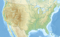 Corona Heights Park Show map of the US | |
| Type | Municipal (San Francisco) |
| Location | San Francisco |
| Coordinates | 37°45′53″N 122°26′21″W / 37.7646522°N 122.4391379°W / 37.7646522; -122.4391379Coordinates: 37°45′53″N 122°26′21″W / 37.7646522°N 122.4391379°W / 37.7646522; -122.4391379[1] |
| Area | 15 acres (6.1 ha)[2] |
| Open | All year |
Corona Heights Park is a park in the Castro and Corona Heights neighborhoods of San Francisco, California, United States. It is situated immediately to the south of Buena Vista Park. Corona Heights is bounded in part by Flint Street on the east, Roosevelt Way to the north, and 16th Street to the south. The base of the hill is at approximately 300 feet (91 m), while the peak extends to 520 feet (158 m) above sea level.[3]
Corona Heights Playground and the Randall Museum are located within the Corona Heights Park. The whole area is underlain by Franciscan chert bedrock, and a large percentage of the hill is barren. At the hilltop, the chert bedrock in terra cotta red is clearly visible.[2] The steps leading up to the peak are not supported by handrails. The peak of the hill is windy, but it offers an unobstructed panoramic view of the city of San Francisco from downtown to the Twin Peaks.
Contents
1 Natural history
2 History
3 Images
4 Popular culture
5 See also
6 References
7 External links
Natural history[edit]
Portions of Corona Heights park are made up of native plant communities protected under the natural areas program as well as non-local plants. The park is home to native reptiles, including northern and southern alligator lizards and garter snakes. Butterflies like the anise swallowtail, red admiral and cabbage white can be seen flying in the park. Red-tailed hawks and common ravens can be seen over the park on most days. California scrub jays, mourning doves, downy woodpeckers, chestnut-backed chickadees, pygmy nuthatches, bushtits, American robins, California towhees, white-crowned sparrows, dark-eyed juncos, American goldfinches, and house finches nest in or near the park.
History[edit]
The property has been known as Rocky Hill or Rock Hill, and the Fist (from the upthrusting chert rock boulders at its 540 ft. peak).[4] In the 1800s, Rock Hill was the site of a quarry and brick factory, which were closed by the 1920s.
In 1928, Josephine Randall, the Superintendent of Recreation for the San Francisco Recreation & Parks Department, proposed that the City buy the 16 acres of Rock Hill for recreation. In 1941, it was purchased for $27,333 and officially named Corona Heights.[4]
Images[edit]

View of the park from Roosevelt Way

Steps leading up to the top of the hill
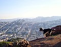
View from the hill

View downtown from the hill

View from the hill

View from the hill

Franciscan chert dominates the barren hill


Popular culture[edit]
Corona Heights is prominently featured in the 1977 horror novel "Our Lady of Darkness" by Fritz Leiber.
See also[edit]
- List of hills in San Francisco
References[edit]
^ "Corona Heights Playground". Geographic Names Information System. United States Geological Survey. Retrieved 2012-03-16..mw-parser-output cite.citation{font-style:inherit}.mw-parser-output q{quotes:"""""""'""'"}.mw-parser-output code.cs1-code{color:inherit;background:inherit;border:inherit;padding:inherit}.mw-parser-output .cs1-lock-free a{background:url("//upload.wikimedia.org/wikipedia/commons/thumb/6/65/Lock-green.svg/9px-Lock-green.svg.png")no-repeat;background-position:right .1em center}.mw-parser-output .cs1-lock-limited a,.mw-parser-output .cs1-lock-registration a{background:url("//upload.wikimedia.org/wikipedia/commons/thumb/d/d6/Lock-gray-alt-2.svg/9px-Lock-gray-alt-2.svg.png")no-repeat;background-position:right .1em center}.mw-parser-output .cs1-lock-subscription a{background:url("//upload.wikimedia.org/wikipedia/commons/thumb/a/aa/Lock-red-alt-2.svg/9px-Lock-red-alt-2.svg.png")no-repeat;background-position:right .1em center}.mw-parser-output .cs1-subscription,.mw-parser-output .cs1-registration{color:#555}.mw-parser-output .cs1-subscription span,.mw-parser-output .cs1-registration span{border-bottom:1px dotted;cursor:help}.mw-parser-output .cs1-hidden-error{display:none;font-size:100%}.mw-parser-output .cs1-visible-error{font-size:100%}.mw-parser-output .cs1-subscription,.mw-parser-output .cs1-registration,.mw-parser-output .cs1-format{font-size:95%}.mw-parser-output .cs1-kern-left,.mw-parser-output .cs1-kern-wl-left{padding-left:0.2em}.mw-parser-output .cs1-kern-right,.mw-parser-output .cs1-kern-wl-right{padding-right:0.2em}
^ ab "Corona Heights". Bandit notes. May 1999. Retrieved 2012-03-16.
^ "Detailed information on Corona Heights as part of a study commissioned by the City Council of San Francisco" (PDF). Archived from the original (PDF) on 2008-04-10. Retrieved 2012-03-16.
^ ab "Corona Heights Park History". San Francisco Parks Alliance. Retrieved 7 July 2016.
External links[edit]
| Wikimedia Commons has media related to Corona Heights Park. |
- Hills in San Francisco at MisterSF.com
| ||
| Government |
|  |
| Transit |
| |
| Parks |
| |
| Related articles |
| |
| ||
Categories:
- Parks in San Francisco
- Hills of San Francisco
(window.RLQ=window.RLQ||).push(function(){mw.config.set({"wgPageParseReport":{"limitreport":{"cputime":"0.252","walltime":"0.326","ppvisitednodes":{"value":1186,"limit":1000000},"ppgeneratednodes":{"value":0,"limit":1500000},"postexpandincludesize":{"value":64629,"limit":2097152},"templateargumentsize":{"value":5581,"limit":2097152},"expansiondepth":{"value":15,"limit":40},"expensivefunctioncount":{"value":3,"limit":500},"unstrip-depth":{"value":1,"limit":20},"unstrip-size":{"value":16701,"limit":5000000},"entityaccesscount":{"value":1,"limit":400},"timingprofile":["100.00% 265.536 1 -total"," 52.87% 140.381 1 Template:Infobox_park"," 50.01% 132.799 1 Template:Infobox"," 28.89% 76.706 1 Template:Reflist"," 23.72% 62.994 4 Template:Cite_web"," 20.07% 53.303 1 Template:Cite_gnis"," 19.77% 52.505 1 Template:Location_map"," 10.48% 27.840 1 Template:If_empty"," 10.06% 26.725 1 Template:Coord"," 9.74% 25.857 1 Template:Convert"]},"scribunto":{"limitreport-timeusage":{"value":"0.126","limit":"10.000"},"limitreport-memusage":{"value":4775309,"limit":52428800}},"cachereport":{"origin":"mw2275","timestamp":"20181010021955","ttl":1900800,"transientcontent":false}}});mw.config.set({"wgBackendResponseTime":413,"wgHostname":"mw2275"});});

 Clash Royale CLAN TAG

